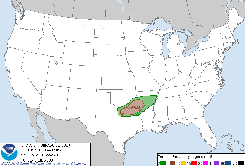
Little Rock, AR...Fort Smith, AR...Longview, TX...North Little Rock, AR...Pine Bluff, AR...
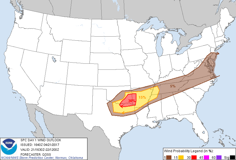
Probabilistic Damaging Wind Graphic
Probability of damaging thunderstorm winds or wind gusts of 50 knots or higher within 25 miles of a point. Hatched Area: 10% of greater probability of wind gusts 65 knots or greater within 25 miles of a point.
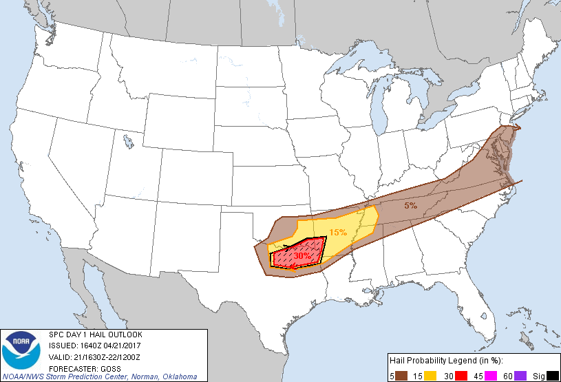
Day 1 Wind Risk
Area (sq. mi.)
Area Pop.
Some Larger Population Centers in Risk Area
30 %
22,917
894,759
Fort Smith, AR...Sherman, TX...Paris, TX...Denison, TX...Van Buren, AR...
Memphis, TN...Little Rock, AR...Wichita Falls, TX...Tyler, TX...Fort Smith, AR...
5 %
212,966
39,227,866
Philadelphia, PA...Baltimore, MD...Washington, DC...Oklahoma City, OK...Nashville, TN...
SPC AC 211640
Day 1 Convective Outlook
NWS Storm Prediction Center Norman OK
1140 AM CDT Fri Apr 21 2017
Valid 211630Z - 221200Z
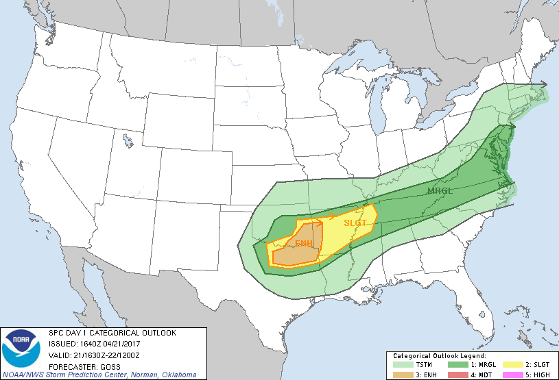
...THERE IS AN ENHANCED RISK OF SEVERE THUNDERSTORMS ACROSS PARTS OF
SOUTHEAST OKLAHOMA AND THE ARKLATEX...AND ADJACENT NORTH TEXAS...
...THERE IS A SLIGHT RISK OF SEVERE THUNDERSTORMS FROM THE
MID-MISSISSIPPI VALLEY AREA WEST-SOUTHWEST INTO PARTS OF OKLAHOMA
AND NORTH TEXAS...
...THERE IS A MARGINAL RISK OF SEVERE THUNDERSTORMS EXTENDING FROM
THE MID-ATLANTIC REGION WEST-SOUTHWEST INTO THE SOUTHERN PLAINS...
...SUMMARY...
Severe thunderstorms capable of producing damaging gusts, large hail
and a few tornadoes are expected through tonight from parts of the
southern Plains into the Ozark Plateau. Isolated severe
thunderstorms may also impact portions of the Mid-South into the
Mid-Atlantic with wind and hail.
...Synopsis...
While an upper-level trough moves across Ontario/Quebec and the
adjacent northeast U.S. and a second over the northeast Pacific
reaches the West Coast late, the main trough associated with the
primary convective/severe risk today is currently shifting into the
central U.S. An initial perturbation within this trough will shift
across Kansas/Oklahoma with time, reaching the Ozarks overnight.
Meanwhile, a strong northwesterly mid- and upper-level jet on the
back side of the trough will maintain broader cyclonic flow over the
central U.S. through the period, in the wake of the passage of the
initial/aforementioned smaller-scale perturbation.
At the surface, a cold front currently extends from NY/PA
southwestward across the mid-South to Arkansas, and then westward
roughly along the Red River Valley. Here, convectively-induced low
moving along the front will allow some brief retreat of the boundary
northward across the southeast Oklahoma/southern Arkansas vicinity
as the low moves quickly eastward through the afternoon. In the
wake of the low, a southward surge of the convectively reinforced
front is expected across the southern Plains through the end of the
period.
...Southern Plains eastward across the Ozarks/mid MS Valley...
A fast-moving/slightly elevated MCS continues moving across Oklahoma
at this time, just north of the surface front now draped across
southern Oklahoma. This early/well-organized cluster of storms
complicates the forecast substantially, as current model guidance --
notably CAM runs and in particular the latest HRR -- have failed to
depict this MCS almost entirely. Convective outflow on the southern
fringe of this line of storms is shifting quickly southeast across
southwest and south central Oklahoma, where it has overtaken the
synoptic front and resulted in a convectively reinforced frontal
surge which should continue into north Texas with time.
Ahead of this fast-moving system -- extrapolated to reach western
Arkansas and southeast Oklahoma by 18Z, a moist/slowly destabilizing
airmass is in place near and south of the synoptic front. Slight
northward advance of the front will occur ahead of the MCS, but
eventual southward suppression is expected as the MCS passes and
convective outflow interacts with the front.
The eventual location of the outflow/front conglomerate will be
significant, as it will serve as a northern fringe of
later-to-be-realized surface-based severe threat expected to evolve
across the Arklatex into north Texas. Redevelopment of convection
south of the ongoing MCS -- near and ahead of the advancing
front/outflow is expected, and with moderate instability in
conjunction with a favorably sheared environment, supercells are
anticipated along with attendant risks for very large hail, locally
damaging winds, and a few tornadoes. Risk should spread east across
the Arklatex and southeast across north Texas this evening, before
diminishing in conjunction with diurnal cooling/stabilization.
Given potential for greatest severe risk to extend farther south and
east than prior outlooks indicated due to ongoing convective
evolution, the ENH risk area is being adjusted southward a bit
toward the DFW metroplex, and eastward into the Arklatex.
Farther north, the ongoing MCS should continue across Arkansas
today, possibly continuing across the mid-Mississippi Valley later
this afternoon and evening. With some severe risk -- including
potential for locally damaging winds and hail -- extending east of
the river, either with this MCS or else with later/convective
redevelopment, will extend SLGT risk east into parts of KY and TN.
...Mid-Atlantic region westward into the TN Valley...
Scattered showers and a few thunderstorms are ongoing at this time
along the cold front, which currently extends from central
NY/western PA southwestward across eastern Kentucky/middle
Tennessee. As this front advances very slowly southeastward today,
heating through scattered to broken cloud cover will support
continued/modest destabilization, with mixed-layer CAPE 500 to 1000
J/kg expected in the pre-frontal warm sector this afternoon. Flat
to weakly anticyclonic flow aloft from roughly the mountains east
through evening suggests isolated coverage of stronger storms,
though 30 to 40 kt mid-level west-southwest flow will contribute to
shear sufficient for organized -- possibly weakly rotating --
updrafts. As such, risk for hail and/or locally damaging winds will
be possible with a few sustained storms within the MRGL risk area.
..Goss.. 04/21/2017
CLICK TO GET WUUS01 PTSDY1 PRODUCT
NOTE: THE NEXT DAY 1 OUTLOOK IS SCHEDULED BY 2000Z