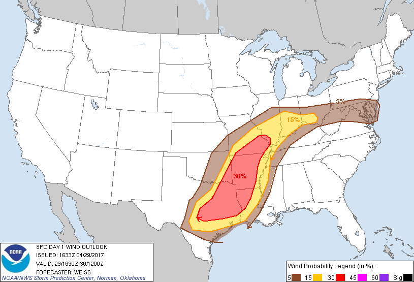
Probability of damaging thunderstorm winds or wind gusts of 50 knots or higher within 25 miles of a point. Hatched Area: 10% of greater probability of wind gusts 65 knots or greater within 25 miles of a point.
Day 1 Wind Risk
Area (sq. mi.)
Area Pop.
Some Larger Population Centers in Risk Area
30 %
132,895
9,223,810
Austin, TX...Shreveport, LA...Little Rock, AR...Mesquite, TX...Waco, TX...
Columbus, OH...Baltimore, MD...Washington, DC...Oklahoma City, OK...Tulsa, OK...
SPC AC 291633
Day 1 Convective Outlook
NWS Storm Prediction Center Norman OK
1133 AM CDT Sat Apr 29 2017
Valid 291630Z - 301200Z
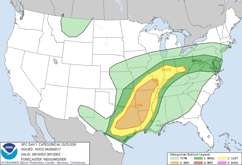
...THERE IS AN ENHANCED RISK OF SEVERE THUNDERSTORMS FROM
CENTRAL/EASTERN TEXAS ACROSS THE ARKLATEX INTO SOUTHERN MISSOURI...
...THERE IS A SLIGHT RISK OF SEVERE THUNDERSTORMS SURROUNDING THE
ENHANCED RISK FROM SOUTHERN TEXAS INTO THE OHIO VALLEY...
...THERE IS A MARGINAL RISK OF SEVERE THUNDERSTORMS FROM THE
SOUTHERN PLAINS ACROSS THE OHIO VALLEY INTO THE MID-ATLANTIC
STATES...
...SUMMARY...
Severe thunderstorms are expected from parts of south central Texas
northeastward to portions of the Ohio Valley and northern Middle
Atlantic region, especially this afternoon and evening. The most
likely region for severe weather will from eastern Texas across
western and central Arkansas into southern Missouri. Storms will be
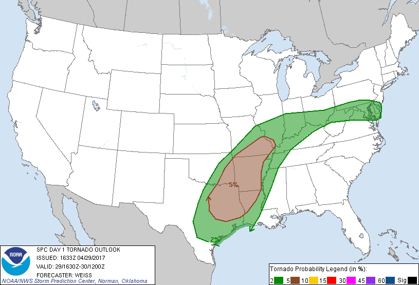
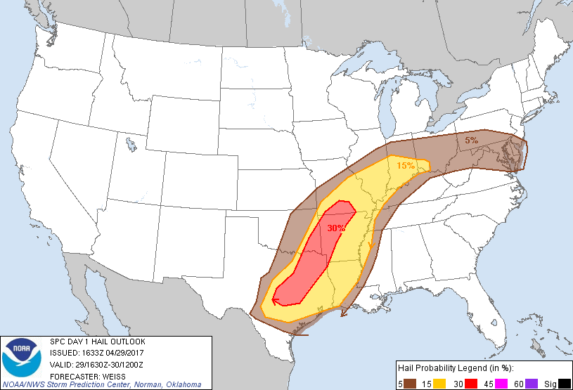
capable of large hail, damaging winds, and a few tornadoes.
...Central/Eastern Texas into southern Missouri...
An upper low near the Four-Corners regions is expected to move
eastward through the period reaching the Texas Panhandle and western
Oklahoma late tonight. Strong mid-upper level winds associated with
the low will translate across west Texas and over the southern
Plains tonight, accompanied by 150-180 m height falls at 500 mb. At
lower levels in advance of the upper low, a broad low-level jet is
in place from eastern parts of Texas and Oklahoma into Louisiana and
Arkansas with 50-60 kt winds in the 1-2 km agl level. These factors
will provide strong low-level shear throughout the period, with
strengthening deep-layer shear progressing eastward across the
southern plains toward the lower Mississippi Valley tonight.
At the surface, the primary low over eastern Oklahoma is forecast to
move mainly northward into southeast Kansas/southwest Missouri
tonight. A cold front currently extending southwestward from the
low toward the Big Bend region will advance into central/south
central Texas by this evening, and arc across central Arkansas into
southwest Louisiana by the end of the period. A quasi-stationary
front extending east-northeast from the low into southern Illinois
will move little, and an outflow boundary persists south of the
front across the Missouri/Arkansas border eastward into Kentucky may
serve as the effective focus for storms.
Ample low-level moisture is present over the warm sector with
surface dew points of generally in the low 70s. Extensive cloud
cover over the region will tend to inhibit stronger diabatic heating
to occur, although breaks in overcast will promote local areas of
more focused heating/destabilization this afternoon. A capping
inversion evident in 12Z soundings at FWD, SHV and LZK is likely to
limit convective development in advance of forced bands of storms,
although storms currently near the Sabine River may persist as they
move northeast this afternoon in association with a weaker
perturbation evident in water vapor imagery.
Otherwise, storms from southwest Missouri into extreme eastern
Oklahoma are expected to spread eastward with time with
intensification expected this afternoon. Some southward development
along the cold front is also expected by mid-late afternoon as
stronger heating appears likely over central into northeast Texas.
NWP guidance including CAM forecasts suggests potential for several
bands/lines of storms to progress eastward with some bowing segments
developing. Large hail and damaging wind gusts will be possible
with more intense cells. A few tornadoes will also be possible,
especially with any discrete storms that can develop ahead of the
cold front, as well as within QLCS mesovortices that may develop.
The activity is likely to progress eastward during the overnight
hours with a continued severe threat.
...Ohio Valley into the Mid-Atlantic States...
Corridors of eastward-moving precipitation including heavy rainfall
and a few strong storms will continue to reinforce a generally
west/east-oriented frontal zone from the Ohio
Valley to the coastal Northeast States. A gradually weakening
low-level jet and moist conveyor, along with prevalent rising upper
heights, may allow for some northward shift of the effective
boundary and increasingly moist warm sector this afternoon.
Regardless, one or more storm clusters ongoing across the
upper Ohio Valley at this time may persist or reinvigorate
in vicinity of the effective frontal zone toward PA/Delmarva
vicinity with mainly a damaging wind risk. Other storms are expected
to develop near the effective warm front from MO into IL
and spread eastward with damaging winds and severe hail as the
primary severe risks.
..Weiss/Mosier.. 04/29/2017
CLICK TO GET WUUS01 PTSDY1 PRODUCT
NOTE: THE NEXT DAY 1 OUTLOOK IS SCHEDULED BY 2000Z