Peoria, IL...Wichita Falls, TX...Champaign, IL...Bloomington, IL...Lafayette, IN...
2 %
203,230
10,434,134
Indianapolis, IN...Oklahoma City, OK...Kansas City, MO...Wichita, KS...Amarillo, TX...
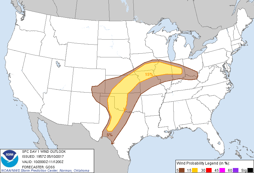
Probabilistic Damaging Wind Graphic
Probability of damaging thunderstorm winds or wind gusts of 50 knots or higher within 25 miles of a point. Hatched Area: 10% of greater probability of wind gusts 65 knots or greater within 25 miles of a point.
Day 1 Wind Risk
Area (sq. mi.)
Area Pop.
Some Larger Population Centers in Risk Area
15 %
183,058
11,337,881
Indianapolis, IN...Oklahoma City, OK...Kansas City, MO...Wichita, KS...Overland Park, KS...
SPC AC 101957
Day 1 Convective Outlook
NWS Storm Prediction Center Norman OK
0257 PM CDT Wed May 10 2017
Valid 102000Z - 111200Z
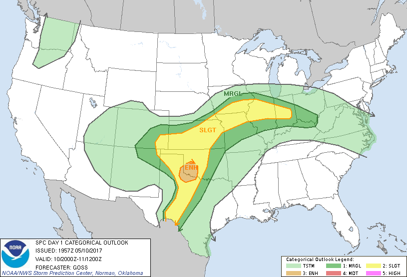
...THERE IS AN ENHANCED RISK OF SEVERE THUNDERSTORMS ACROSS PORTIONS
OF SOUTHWEST OKLAHOMA AND NORTHWEST TEXAS...
...THERE IS A SLIGHT RISK OF SEVERE THUNDERSTORMS EXTENDING FROM
PARTS OF INDIANA/ILLINOIS WEST-SOUTHWEST TO SOUTHEAST COLORADO...AND
SOUTHWARD INTO TEXAS...
...THERE IS A MARGINAL RISK OF SEVERE THUNDERSTORMS SURROUNDING THE
SLIGHT RISK AREA...
...SUMMARY...
Scattered severe thunderstorms are expected along a corridor from
the southern Plains to the middle Mississippi Valley. The strongest
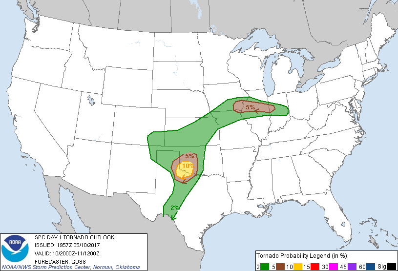
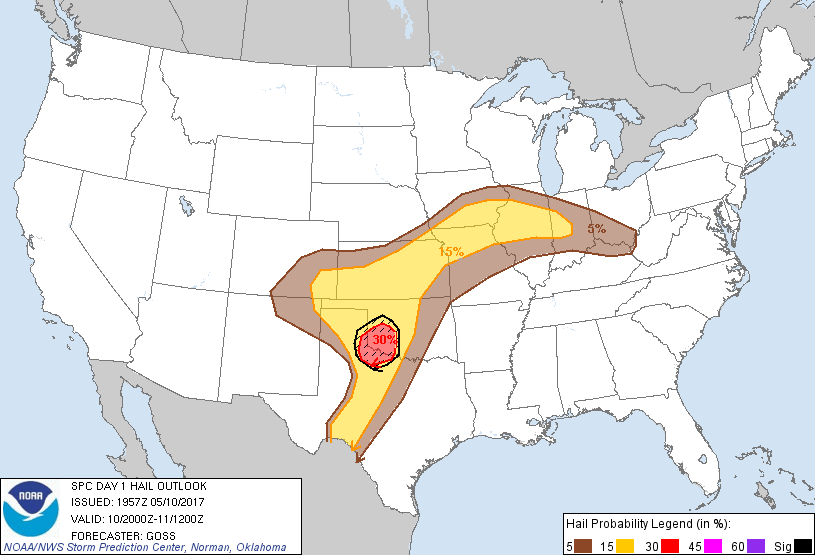
activity should focus across parts of northwest Texas into southwest
Oklahoma where very large hail and a few tornadoes are possible.
...Discussion...
Forecast reasoning from prior outlooks remains on track, with
current convective evolution generally in line with expectations.
As such, changes with respect to the current outlook are limited to
line tweaks -- particularly with the ENH risk area which is being
shifted slightly southward. With convective outflow currently
aligned from roughly El Reno, OK southwest through Childress, TX to
a dryline/outflow intersection point in Motley County TX, the
centroid of greatest severe risk appears to be focused a tad farther
south. Along with risk for large hail -- including with a
developing storm near the dryline/outflow intersection, greatest
tornado risk appears likely within this southwest-to-northeast
corridor in the vicinity of the outflow.
Otherwise, no major changes to the outlook appear necessary at this
time.
..Goss.. 05/10/2017
.PREV DISCUSSION... /ISSUED 1135 AM CDT Wed May 10 2017/
...Northwest TX/western OK...
A persistent MCS continues to generally weaken as it spreads
northeastward across south-central/southeast KS at late morning. A
trailing outflow boundary extends southwestward and continues to
exhibit some southward movement across west-central/southwest OK
into parts of the northwest TX low rolling Plains and Caprock
vicinity.
A closed mid/upper trough over eastern AZ/western NM this morning
will gradually accelerate east-northeastward, reaching the
south-central High Plains late tonight. 12Z upper-air analysis
featured a belt of a strong southwesterly winds (50+ kt at 500mb and
100 kt 250mb) over northern Mexico into the southern High Plains.
The strong mid/high-level winds will continue to spread
east-northeastward through afternoon and evening atop an
eastward-mixing dryline across much of west/northwest TX.
An northeast-advecting elevated mixed layer atop middle 60s F
surface dewpoints will contribute to 2000-2750 J/kg MLCAPE in west
TX and western OK areas to the east of the dryline and south of the
remnant outflow boundary. Severe thunderstorm development is most
likely by mid/late afternoon near the dryline and modifying
outflow-related triple point across the southern TX Panhandle/TX low
rolling Plains and western parts of north TX into southwest OK.
Effective shear in excess of 50 kt will support supercells capable
of very large hail. While low-level shear will initially be weak,
the influence of the outflow boundary and an evening-time increase
in a southerly low-level jet will support the potential for
tornadoes.
...IA/MO/IL/IN...
A warm front will continue to slowly spread northward across
southeast IA and north-central portions of IL/IN and southern OH,
while a weak surface wave develops east-southeastward across the
region through tonight. Surface dewpoints in the low/middle 60s F
near and south of the front will contribute to MLCAPE values of
1000-2000 J/kg with weak inhibition by mid-afternoon. Aided by an
MCV/weak mid-level disturbance, initial strong to severe
thunderstorm development should occur this afternoon across southern
IA and northern MO into IL. Deep-layer shear will be favorable for
initial supercells, while low-level shear will be adequate for some
tornado risk, particularly just east of the surface wave. Storms are
likely to cluster over time and move east-southeastward into IL/IN
from late afternoon into evening, potentially with an increased risk
for damaging winds.
...TX Edwards Plateau/Big Country late tonight...
The dryline will likely stall this afternoon and then retreat some
to the west late this evening. Thunderstorm development will be
possible along this boundary overnight, when lingering
moderate-strong buoyancy and substantial deep-layer shear will
support a risk of storm clusters capable of producing large hail and
damaging winds.
CLICK TO GET WUUS01 PTSDY1 PRODUCT
NOTE: THE NEXT DAY 1 OUTLOOK IS SCHEDULED BY 0100Z