Virginia Beach, VA...Lexington-Fayette, KY...Norfolk, VA...Chesapeake, VA...Columbus, GA...
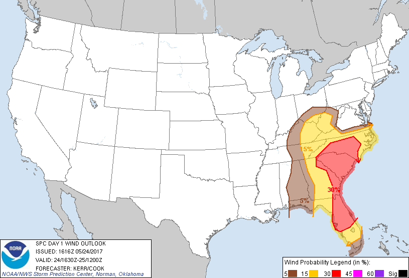
Probabilistic Damaging Wind Graphic
Probability of damaging thunderstorm winds or wind gusts of 50 knots or higher within 25 miles of a point. Hatched Area: 10% of greater probability of wind gusts 65 knots or greater within 25 miles of a point.
SPC AC 241616
Day 1 Convective Outlook
NWS Storm Prediction Center Norman OK
1116 AM CDT Wed May 24 2017
Valid 241630Z - 251200Z
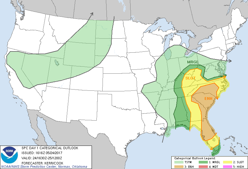
...THERE IS AN ENHANCED RISK OF SEVERE THUNDERSTORMS THROUGH THIS
AFTERNOON AND EVENING ACROSS MUCH OF THE CAROLINAS AND EASTERN
GEORGIA INTO THE CENTRAL FLORIDA PENINSULA...
...THERE IS A SLIGHT RISK OF SEVERE THUNDERSTORMS ACROSS SURROUNDING
AREAS OF THE CENTRAL AND SOUTHERN APPALACHIANS...EASTERN GULF AND
SOUTH ATLANTIC COAST STATES...
...THERE IS A MARGINAL RISK OF SEVERE THUNDERSTORMS ACROSS
SURROUNDING AREAS OF THE OHIO VALLEY AND SOUTHEAST...
...SUMMARY...
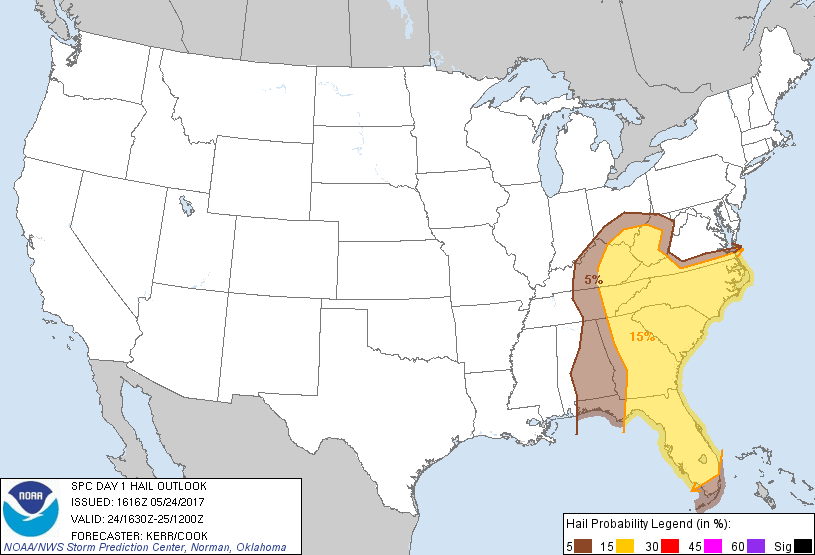
Severe thunderstorm activity may impact much of the south Atlantic
Seaboard today, accompanied by a risk for tornadoes, potentially
damaging wind gusts, and some hail.
...Synopsis...
Large-scale mid/upper troughing appears likely to slowly shift east
of the Mississippi Valley through the remainder of this period, as a
significant upstream trough digs through portions of the northern
Plains/Rockies and intermountain region. The orientation of the
lead troughing may continue to take on more of a neutral to slightly
negative tilt, as significant smaller scale impulse pivots through
its base, east of the lower Mississippi Valley through the
Southeast. Farther north, an embedded lower/mid tropospheric
cyclone is forecast to turn east of the middle Mississippi Valley
through the lower Ohio Valley, and support further deepening of an
occluding surface low to the west of the central Appalachians.
Seasonably high moisture content air is initially suppressed to the
south, off south Atlantic coastal areas through parts of southern
Georgia/northern Florida into the eastern Gulf of Mexico, associated
with a prior front. However, model output indicates a substantive
moisture return through the warm sector today, across eastern
Georgia and much of the Carolinas. This is expected to contribute
to moderately large CAPE, in the presence of strengthening southerly
low-level flow (30-50 kt at 850), as 50-70 cyclonic 500 mb flow
overspreads the region.
...Southeast...
Considerable strong/severe storm development is now well underway in
the presence of increasing instability and shear, along the
southeastern slopes of the southern Appalachians, southward through
parts of eastern Alabama/central and southern Georgia and northern
Florida. The potential negative influence of a large thunderstorm
cluster, now near/west through north of Jacksonville Fl area, on
activity to the northwest remains at least somewhat unclear.
However, a general increase in thunderstorm development and
intensity still seems probable through this evening, near the
strengthening 850 jet, from parts of the Florida peninsula into the
Carolinas.
Activity now near the southern Appalachians appears aided by forcing
in the exit region of the mid/upper jet, and may eventually
merge/consolidate with activity to the south, while spreading east
northeastward to the lee of the southern Appalachians through early
evening. This forcing is expected to track along a stalling or
slowly retreating frontal zone across the southern Appalachians
piedmont, which may provide a focus for storms capable of producing
tornadoes, in addition to potentially damaging wind gusts.
...Ohio Valley into western slopes of central Appalachians...
Delineation of severe probabilities is somewhat unclear across the
region beneath the evolving mid/upper system. The mid-level cold
core appears likely to dig well to the southwest of the central
Appalachians (Ozark Plateau through upper portions of the lower
Mississippi Valley) through the daytime hours, and an initial area
of convectively generated precipitation is now overspreading much
of eastern Kentucky and Tennessee, into the central Appalachians.
It still seems at least possible that clearing beneath the mid-level
dry slot in the wake of the lead convection will provide potential
for substantive destabilization by late afternoon, as it spreads
toward the central Appalachians. Followed by increasing forcing for
ascent associated with a mid-level cyclonic vorticity center now
redeveloping across and northeast of the Nashville TN area, given
any appreciable boundary layer destabilization, the environment may
become conducive to low topped supercells.
There also may be at least some short term severe weather potential
in the vicinity of one initial surface low center near Cincinnati
OH. For details refer to SPC Mesoscale Discussion 827.
..Kerr/Cook.. 05/24/2017
CLICK TO GET WUUS01 PTSDY1 PRODUCT
NOTE: THE NEXT DAY 1 OUTLOOK IS SCHEDULED BY 2000Z