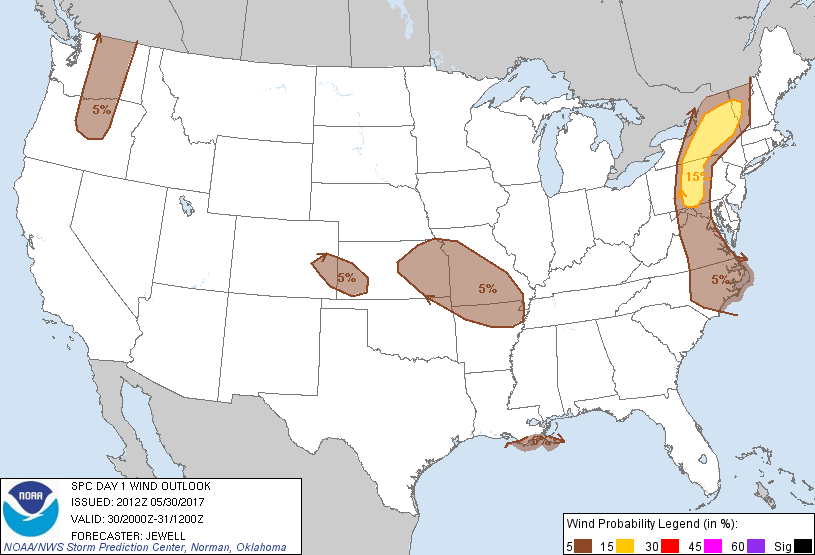
Probability of damaging thunderstorm winds or wind gusts of 50 knots or higher within 25 miles of a point. Hatched Area: 10% of greater probability of wind gusts 65 knots or greater within 25 miles of a point.
Washington, DC...Kansas City, MO...Raleigh, NC...Norfolk, VA...Chesapeake, VA...
SPC AC 302012
Day 1 Convective Outlook CORR 1
NWS Storm Prediction Center Norman OK
0312 PM CDT Tue May 30 2017
Valid 302000Z - 311200Z
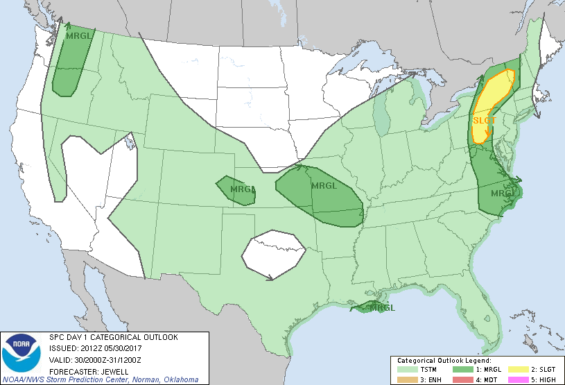
...THERE IS A SLIGHT RISK OF SEVERE THUNDERSTORMS ACROSS CENTRAL PA
INTO UPSTATE NEW YORK...
...THERE IS A MARGINAL RISK OF SEVERE THUNDERSTORMS FROM THE MID
ATLANTIC NORTHWARD...
...THERE IS A MARGINAL RISK OF SEVERE THUNDERSTORMS OVER COASTAL
SOUTHEAST LOUISIANA...
...THERE IS A MARGINAL RISK OF SEVERE THUNDERSTORMS ACROSS EASTERN
KANSAS INTO MISSOURI...
...THERE IS A MARGINAL RISK OF SEVERE THUNDERSTORMS OVER EAST
CENTRAL COLORADO INTO WESTERN KANSAS...
...THERE IS A MARGINAL RISK OF SEVERE THUNDERSTORMS OVER CENTRAL
OREGON AND WASHINGTON...
CORRECTED FOR GRAPHICS
...SUMMARY...
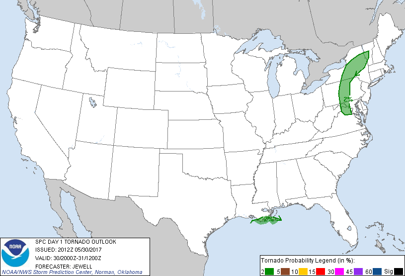
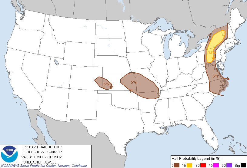
A few severe thunderstorms capable of large hail, damaging winds,
and perhaps a brief/weak tornado will be possible this afternoon and
evening from the lower Great Lakes and Adirondacks to North
Carolina. Elsewhere, a few strong/severe storms may occur across the
central Plains/Ozarks, central Gulf Coast, and Pacific Northwest.
...Northern VA northward across PA and NY...
Previous forecast remains largely on track with strong to severe
storms across central PA into NY. Strong heating also continues
farther south across western MD into VA, where a pocket of mid 60s
dewpoints remains. Several CAMs suggest a few strong cells
developing later this afternoon, spreading southeastward across
northern and east central VA. The long hodographs suggest mainly
single cell mode with hail the main threat, although gusty winds are
always possible. Eastward extent of the threat will be limited by
cooler capped air mass roughly along and east of the D.C. area.
...Eastern CO into western KS...
Added a small Marginal risk for hail and wind for expected isolated
development this afternoon. Visible imagery shows substantial CU
fields around Limon eastward, and continued heating should yield a
few storms. Northwesterly flow aloft combined with steep lapse rate
profiles should allow storms to travel southeastward into Kansas.
...Southern LA...
Extensive rain and storms continue across much of southern LA, with
the strongest activity along the coast where better inflow exists
off the Gulf and with less outflow/overturning. Thus, have nudged
Marginal risk southward for a brief/weak tornado or wind threat.
...Eastern KS into MO...
Best instability currently exists across Kansas, with drier air over
northern MO, and have shunted northern extent of the Marginal risk
south. Visible imagery shows good CU development over eastern KS as
of 20Z, and a few cells are expected with hail or wind. Other
activity continues into northern AR, with sporadic marginal hail
cores noted on radar.
..Jewell.. 05/30/2017
.PREV DISCUSSION... /ISSUED 1045 AM CDT Tue May 30 2017/
...NY/VT/PA/MD/VA...
Only minor changes have been made to the ongoing forecast in this
area. Visible satellite imagery shows a corridor of daytime heating
occurring from central NY into western PA, then southward into
western MD and northern VA. 12z model guidance remains consistent
that scattered thunderstorms will form in this region, aided by an
approaching shortwave trough now over MI/IN/OH. Afternoon CAPE
values of 1000-2000 J/kg and rather strong west-southwesterly mid
level winds will promote rather fast-moving thunderstorms capable of
damaging winds and some hail. The eastern extent of the severe
threat should be strongly limited by the cool/stable environment
over eastern NY/PA/MD/VA.
...LA...
Radar loops have shown several rotating storms off and just along
the coast of central/southeast LA. This activity may persist for
several more hours, posing a risk of a brief tornado or damaging
wind gust.
...Southern MO/Northern AR...
A remnant area of weak convection is tracking across southeast KS.
Model solutions suggest some intensification may occur with this
activity by mid/late afternoon, with a risk of an isolated severe
cell or two. Gusty/damaging winds and hail would be the main
threat.
...Eastern KS/Northern MO...
A weak surface cold front is sagging southward across IA/NE. This
boundary may be a focus for scattered showers and thunderstorms this
afternoon and evening. Relatively steep low level lapse rates and
sufficient vertical shear indicate a risk of an isolated severe
storm or two capable of gusty winds and hail.
...WA/OR...
A well-defined shortwave trough is approaching the Pacific Northwest
coast. Strong heating is forecast over parts of central WA/OR, with
afternoon temperatures warming through the 80s and into the 90s.
Steep low and mid level lapse rates and sufficient southwesterly
flow aloft suggest a risk of high-based showers and thunderstorms
capable of gusty and locally damaging wind gusts.
CLICK TO GET WUUS01 PTSDY1 PRODUCT
NOTE: THE NEXT DAY 1 OUTLOOK IS SCHEDULED BY 0100Z