Jamestown, ND...Devils Lake, ND...Valley City, ND...
MARGINAL
187,816
2,913,961
Fargo, ND...Duluth, MN...Eau Claire, WI...Rapid City, SD...Bismarck, ND...
Probabilistic Tornado Graphic
Probability of a tornado within 25 miles of a point. Hatched Area: 10% or greater probability of EF2 - EF5 tornadoes within 25 miles of a point.
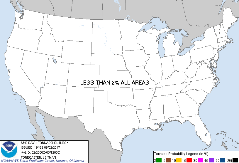
Day 1 Tornado Risk
Area (sq. mi.)
Area Pop.
Some Larger Population Centers in Risk Area
No Risk Areas Forecast
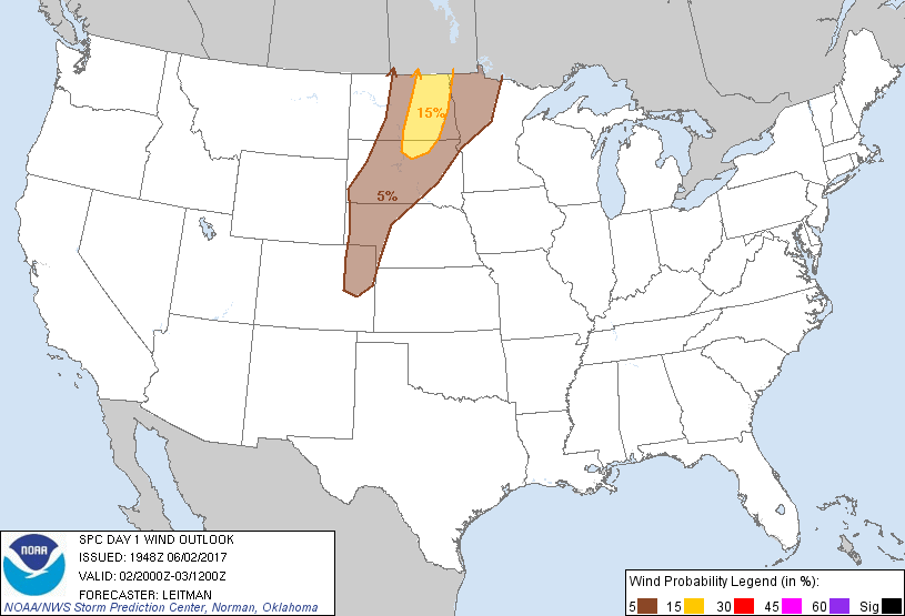
Probabilistic Damaging Wind Graphic
Probability of damaging thunderstorm winds or wind gusts of 50 knots or higher within 25 miles of a point. Hatched Area: 10% of greater probability of wind gusts 65 knots or greater within 25 miles of a point.
Day 1 Wind Risk
Area (sq. mi.)
Area Pop.
Some Larger Population Centers in Risk Area
15 %
30,106
140,806
Jamestown, ND...Devils Lake, ND...Valley City, ND...
5 %
131,496
1,238,552
Fargo, ND...Rapid City, SD...Bismarck, ND...Grand Forks, ND...Moorhead, MN...
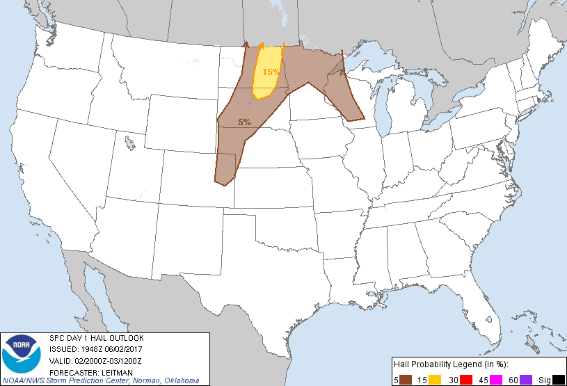
Probabilistic Large Hail Graphic
Probability of hail 1" or larger within 25 miles of a point. Hatched Area: 10% or greater probability of hail 2" or larger within 25 miles of a point.
Day 1 Hail Risk
Area (sq. mi.)
Area Pop.
Some Larger Population Centers in Risk Area
15 %
30,909
167,483
Aberdeen, SD...Jamestown, ND...Devils Lake, ND...Valley City, ND...
5 %
185,474
2,860,410
Fargo, ND...Duluth, MN...Eau Claire, WI...Rapid City, SD...Bismarck, ND...
SPC AC 021948
Day 1 Convective Outlook
NWS Storm Prediction Center Norman OK
0248 PM CDT Fri Jun 02 2017
Valid 022000Z - 031200Z
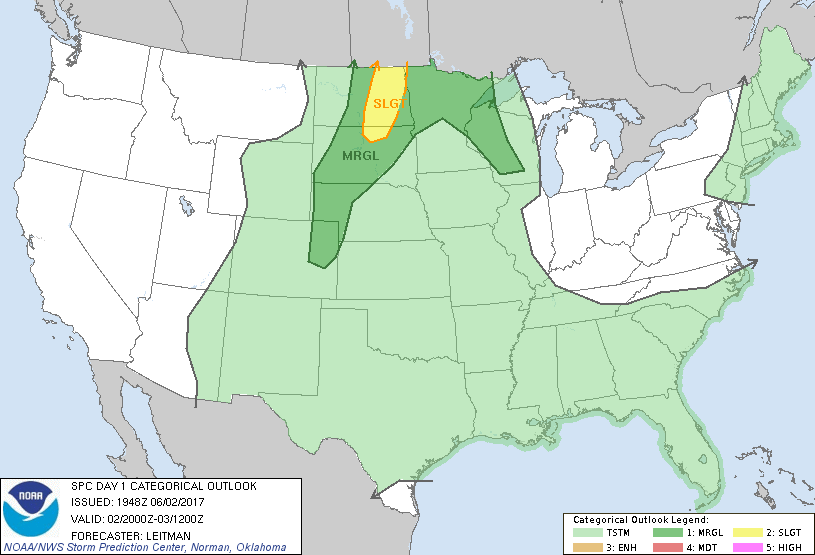
...THERE IS A SLIGHT RISK OF SEVERE THUNDERSTORMS OVER EASTERN NORTH
DAKOTA INTO NORTH-CENTRAL SOUTH DAKOTA...
...THERE IS A MARGINAL RISK OF SEVERE THUNDERSTORMS FROM THE CENTRAL
HIGH PLAINS TO THE NORTHERN PLAINS AND UPPER MISSISSIPPI VALLEY...
...SUMMARY...
Isolated severe hail and wind may accompany thunderstorms through
tonight across parts of the northern Great Plains and upper
Mississippi Valley. In addition, a few strong-to-severe storms will
be possible over the central high plains of western Nebraska and
eastern Colorado.
...20z Update...
Storms were starting to develop ahead of the cold front across
western/central South Dakota along the surface trough. Additional
development further north into North Dakota is expected within the
next few hours as forcing and shear increase toward evening.
Modification of the 12z RAOB at BIS with current surface obs in the
central ND vicinity indicate capping has eroded and visible
satellite shows an expanding cumulus field southward across South
Dakota. Given these trends in observations, the previous outlook
appears on track, and no changes have been made. Reference MCD 939
for more details.
..Leitman.. 06/02/2017
.PREV DISCUSSION... /ISSUED 1124 AM CDT Fri Jun 02 2017/
...Northern Plains into the central High Plains...
Satellite imagery shows a short wave trough progressing eastward
across parts of Montana and Wyoming late this morning. The primary
energy with this system is forecast to lift into the Canadian
Prairie provinces as a surface cold front advances eastward into the
central Dakotas by this evening. The air mass ahead of the front is
warming and destabilizing as moisture increases northward into the
Dakotas with surface dew points currently near 60F within the moist
axis. Forecast soundings indicate steep low-mid level lapse rates
developing with an axis of MLCAPE up to 1500-2000 J/kg expected this
afternoon, especially in parts of central/eastern North Dakota.
As the front moves eastward into the unstable environment, the cap
will weaken with a few thunderstorms expected to develop by mid-late
afternoon along the front. Although vertical shear will be weak
suggesting potential for hybrid pulse storm modes, a dry and
relatively deep sub-cloud layer /large values of DCAPE/ will promote
strong downdrafts with potential for localized damaging wind gusts.
In addition, steep low-mid level lapse rates will also support large
hail with the stronger updrafts. These storms will spread slowly
northeast into parts of northern Minnesota during the evening hours.
Other storms are expected to develop southward along a lee trough
into parts of western Nebraska and eastern Colorado where steep
lapse rates and sufficient moisture will support higher-based
convection. Again, vertical shear will be weak limiting storm
organization, but strong wind gusts and isolated hail will be
possible with stronger primarily pulse cells from mid-afternoon into
the evening hours.
...Upper Mississippi Valley...
As storms spread from eastern North Dakota into northern Minnesota
this evening, a strengthening southwesterly low-level jet is
expected to develop across the area. This will result in stronger
warm advection lift along and north of the northwest-southeast
oriented warm front over the upper Mississippi Valley, which will
support a continuation of strong /primarily elevated/ thunderstorms
from northeast Minnesota into parts of western Wisconsin during the
overnight hours. The stronger storms will have potential to produce
occasional hail.
...Parts of Western and Central Texas...
A complex convective pattern is in place over this region in advance
of a southern-stream vorticity maxima over northern Mexico. Earlier
convection has resulted in the development of at least two MCVs,
with one over southwest Texas south of MAF and another near the
Texas/New Mexico border west of LBB. These features may focus new
convective development this afternoon and evening. However,
previous storms have modified/stabilized the thermodynamic
environment and may limit the coverage of stronger cells. Coupled
with generally weak westerly flow aloft, the overall severe threat
is likely to remain limited.
CLICK TO GET WUUS01 PTSDY1 PRODUCT
NOTE: THE NEXT DAY 1 OUTLOOK IS SCHEDULED BY 0100Z