Austin, TX...Killeen, TX...Round Rock, TX...Temple, TX...Cedar Park, TX...
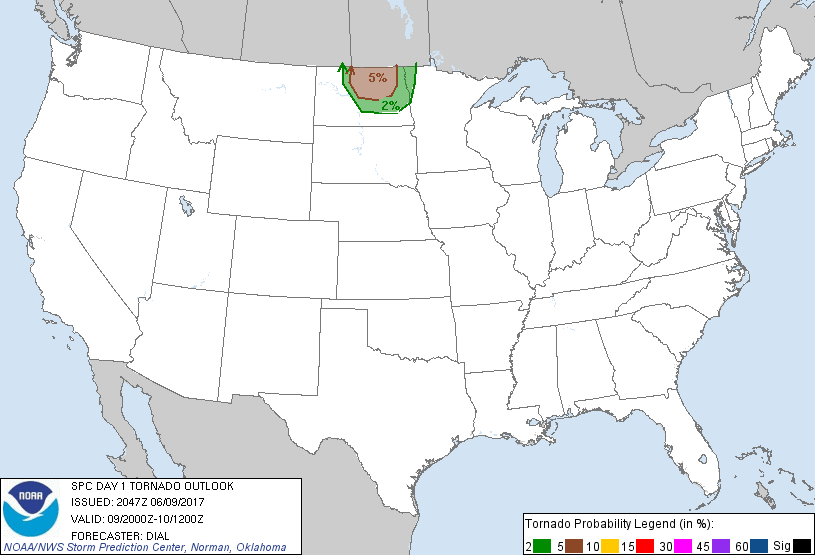
Probabilistic Tornado Graphic
Probability of a tornado within 25 miles of a point. Hatched Area: 10% or greater probability of EF2 - EF5 tornadoes within 25 miles of a point.
Day 1 Tornado Risk
Area (sq. mi.)
Area Pop.
Some Larger Population Centers in Risk Area
5 %
16,990
129,461
Minot, ND...Devils Lake, ND...
2 %
18,710
176,786
Grand Forks, ND...Jamestown, ND...Valley City, ND...Grafton, ND...
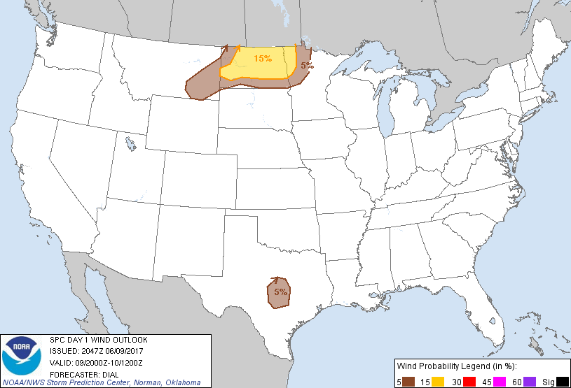
Probabilistic Damaging Wind Graphic
Probability of damaging thunderstorm winds or wind gusts of 50 knots or higher within 25 miles of a point. Hatched Area: 10% of greater probability of wind gusts 65 knots or greater within 25 miles of a point.
Fergus Falls, MN...Bemidji, MN...Williston, ND...Wahpeton, ND...Miles City, MT...
SPC AC 092047
Day 1 Convective Outlook CORR 1
NWS Storm Prediction Center Norman OK
0347 PM CDT Fri Jun 09 2017
Valid 092000Z - 101200Z
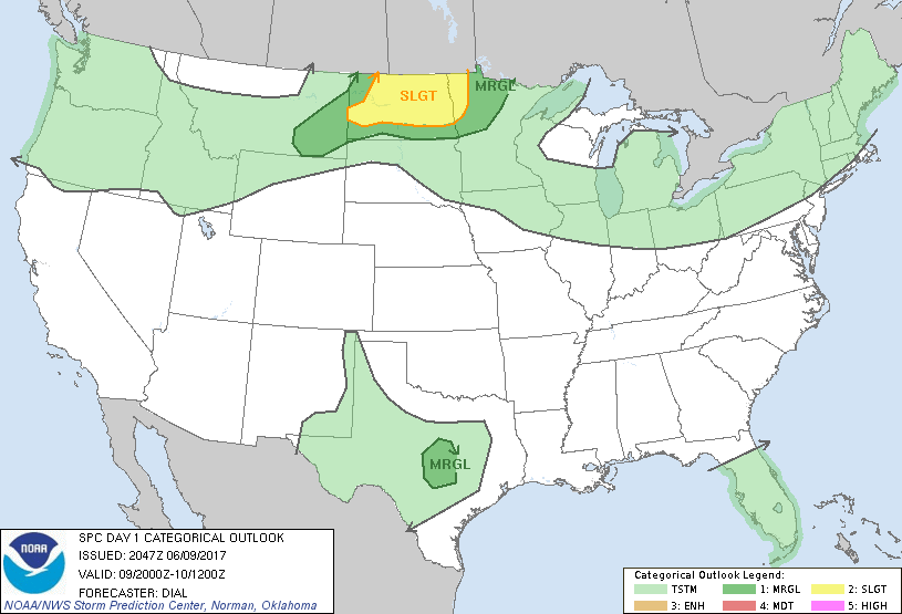
...THERE IS A SLIGHT RISK OF SEVERE THUNDERSTORMS FROM NORTH DAKOTA
INTO NORTHWEST MINNESOTA...
...THERE IS A MARGINAL RISK OF SEVERE THUNDERSTORMS OVER A PORTION
OF THE NORTHERN PLAINS INTO THE NORTHERN MINNESOTA...
...THERE IS A MARGINAL RISK OF SEVERE THUNDERSTORMS OVER A PORTION
OF CENTRAL TEXAS...
CORRECTED FOR DISCUSSION INITIATION TIMES
...SUMMARY...
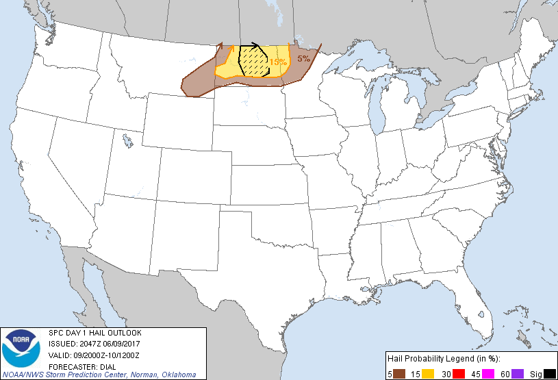
Strong to severe thunderstorms, capable of large hail, damaging
winds, and perhaps a couple tornadoes, remain possible across the
northern Plains this afternoon and early evening. The threat for
isolated hail and strong wind gusts will continue into the
overnight. Other isolated strong storms producing gusty winds may
affect central Texas this afternoon and early evening.
...Discussion...
The previous forecast appears on track, and no significant changes
have been made. Satellite trends suggest severe storms might develop
by 22Z-23Z near the cold front/warm front intersection and in warm
advection zone north of warm front from northwest through north
central ND.
..Dial.. 06/09/2017
.PREV DISCUSSION... /ISSUED 1120 AM CDT Fri Jun 09 2017/
...Northern Plains...
Morning visible satellite imagery shows scattered showers and
thunderstorms affecting parts of northern ND and southeast SK.
Strong heating will occur on the southwest flank of this convection,
where a continued influx of low-level moisture will eventually
reduce the cap and lead to re-development of intense storms.
Activity will likely form over north-central ND by mid/late
afternoon and track southeastward through the evening into western
MN. Large hail and damaging winds are the main threats, with some
concern for very large hail and a tornado or two across central ND
where discrete supercells are most likely. Some evolution to a
bowing line is likely after dark.
Farther west, another cluster of thunderstorms is likely to form
this evening over southeast MT and track into western ND.
Instability will be relatively weak in this region, but sufficiently
steep mid-level lapse rates and deep layer shear will promote
organized storms capable of gusty winds and hail.
...Central TX...
A long-lived convective cluster and associated MCV is moving
southeastward across TX. Most 12z models now suggest that a few
thunderstorms will form on the southwest flank of this system, where
strong instability will be present. Vertical shear will be rather
weak, but steep low-level lapse rates and high CAPE may result in a
few storms capable of strong/damaging wind gusts.
CLICK TO GET WUUS01 PTSDY1 PRODUCT
NOTE: THE NEXT DAY 1 OUTLOOK IS SCHEDULED BY 0100Z