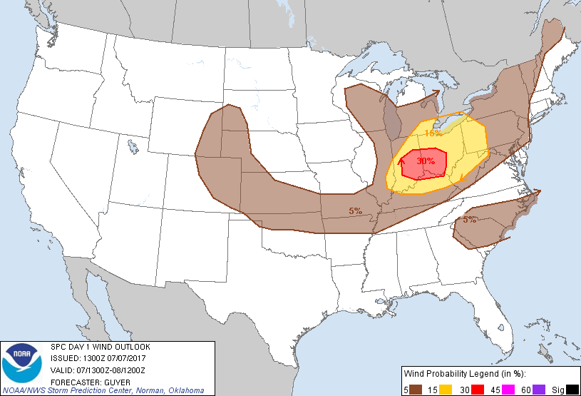
Probability of damaging thunderstorm winds or wind gusts of 50 knots or higher within 25 miles of a point. Hatched Area: 10% of greater probability of wind gusts 65 knots or greater within 25 miles of a point.
   SPC AC 071300

   Day 1 Convective Outlook
   NWS Storm Prediction Center Norman OK
   0800 AM CDT Fri Jul 07 2017

   Valid 071300Z - 081200Z

   ...THERE IS AN ENHANCED RISK OF SEVERE THUNDERSTORMS ACROSS PARTS OF
   IN/OH/KY...

   ...THERE IS A SLIGHT RISK OF SEVERE THUNDERSTORMS ACROSS THE OH
   VALLEY/GREAT LAKES...

   ...THERE IS A MARGINAL RISK OF SEVERE THUNDERSTORMS FROM THE CENTRAL
   HIGH PLAINS TO THE NORTHEAST STATES...

   ...THERE IS A MARGINAL RISK OF SEVERE THUNDERSTORMS ACROSS THE
   CAROLINAS VICINITY...

   ...SUMMARY...
   Severe thunderstorms are expected across the Ohio Valley and
   portions of the lower Great Lakes mainly this afternoon and early
   evening. Other more isolated strong to severe thunderstorms can be
   expected across the central High Plains to the Ozark Plateau and
   possibly the Carolinas vicinity.

   ...Synopsis...
   A relatively amplified large-scale pattern will exist over the CONUS
   today, with multiple shortwave impulses crossing the Midwest,
   Northeast States and Plains to the east of an upper-level ridge
   centered over the Great Basin and Four Corners area.

   ...Ohio Valley/Great Lakes...
   Strengthening mid/high-level west-northwesterly winds are expected
   today amidst cyclonic upper flow. Several subtle and/or convectively
   related disturbances will cross the region today ahead of a more
   consequential disturbance/speed max that will spread southeastward
   from northern MN and reach the Lake MI vicinity by early evening.
   Increasing early-day storms across northern IN could persist
   southeastward today, especially in areas along and west of
   MCS-related early-day outflow across OH, with other peripheral
   development expected near a southeastward-moving front within an
   increasingly moist and unstable environment especially from southern
   IL into IN/OH. For additional early-day details, see Mesoscale
   Discussions 1253 and 1254.

   12Z observed soundings from Davenport IA/Lincoln IL sample a plume
   of relatively steep mid-level lapse rates that will continue to
   advect east-southeastward across the region today, while the
   Davenport IA sounding in particular sampled 40-55 kt high-level
   northwesterly winds. Steepening lapse rates/moderate buoyancy in
   conjunction with strengthening wind aloft will support some
   supercells aside from more prevalent line segments/bows. Bouts of
   severe hail and damaging winds will be possible as storms spread
   southeastward through the afternoon and evening hours, with parts of
   IN/OH into northern KY currently expected to have the greatest
   concentration of severe-caliber storms.

   ...Central High Plains to Ozark Plateau...
   On the periphery of the western states upper ridge, a few weak
   disturbances may top the ridge over the northern Rockies and dig
   southeast toward the High Plains of WY/CO. Forecast soundings across
   the High Plains exhibit surface-6km bulk shear on the order of 35-40
   kt, more than adequate for sustaining organized convection including
   a few supercells where storms develop.

   Elsewhere, strong heating across southern KS/northern OK into
   southern MO should encourage relatively high-based convection along
   southward-moving cold front. Gusty winds are the primary threat with
   this convection.

   ...Carolinas vicinity...
   Isolated strong to severe thunderstorms capable of wind damage
   appear possible across the region mainly this afternoon.

   ..Guyer.. 07/07/2017

   CLICK TO GET WUUS01 PTSDY1 PRODUCT

   NOTE: THE NEXT DAY 1 OUTLOOK IS SCHEDULED BY 1630Z