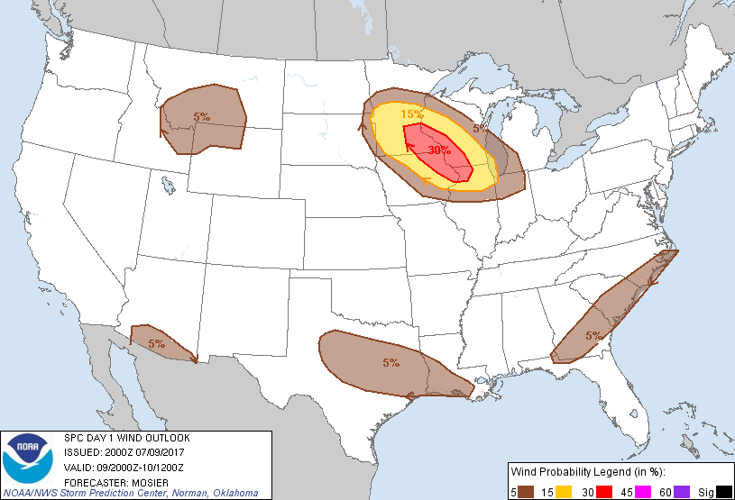
Probability of damaging thunderstorm winds or wind gusts of 50 knots or higher within 25 miles of a point. Hatched Area: 10% of greater probability of wind gusts 65 knots or greater within 25 miles of a point.
SPC AC 092000
Day 1 Convective Outlook
NWS Storm Prediction Center Norman OK
0300 PM CDT Sun Jul 09 2017
Valid 092000Z - 101200Z
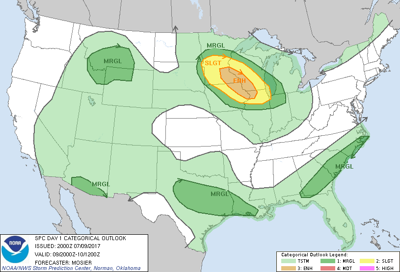
...THERE IS AN ENHANCED RISK OF SEVERE THUNDERSTORMS OVER THE UPPER
MISSISSIPPI VALLEY REGION...
...THERE IS A SLIGHT RISK OF SEVERE THUNDERSTORMS SURROUNDING THE
ENHANCED RISK OVER THE UPPER MIDWEST...
...THERE IS A MARGINAL RISK OF SEVERE THUNDERSTORMS OVER THE UPPER
MIDWEST...
...THERE IS A MARGINAL RISK OF SEVERE THUNDERSTORMS FROM COASTAL
CAROLINAS INTO SOUTHERN GEORGIA...
...THERE IS A MARGINAL RISK OF SEVERE THUNDERSTORMS OVER SOUTHERN
ARIZONA...
...THERE IS A MARGINAL RISK OF SEVERE THUNDERSTORMS OVER THE
NORTHERN ROCKIES...
...THERE IS A MARGINAL RISK OF SEVERE THUNDERSTORMS FROM CENTRAL
TEXAS TO THE LOUISIANA COAST...
...SUMMARY...
Severe thunderstorms are expected late this afternoon into tonight
across the Upper Midwest, particularly across central and southern
Minnesota, northeast Iowa, southwest Wisconsin and northwest
Illinois. Strong thunderstorms may also impact portions of the south
Atlantic coast into southern Georgia, southern Arizona, and portions
of the northern Rockies this afternoon and evening.
...20Z Update...
...Upper MS Valley...
Surface observations and visible satellite imagery place a surface
low near GWR (in far southeast ND) with a warm front extending
southeastward across southern MN (demarcated well by the 80 deg F
isotherm). Thunderstorm development is still expected in the
vicinity of this low later this afternoon and only minor changes
were needed to the outlook in this area. The Marginal and Slight
Risk outlook areas were extended back westward based on the location
of the surface low and recent guidance, which suggest the potential
for isolated development a bit farther west. Explosive convective
development is still anticipated across central MN this evening.
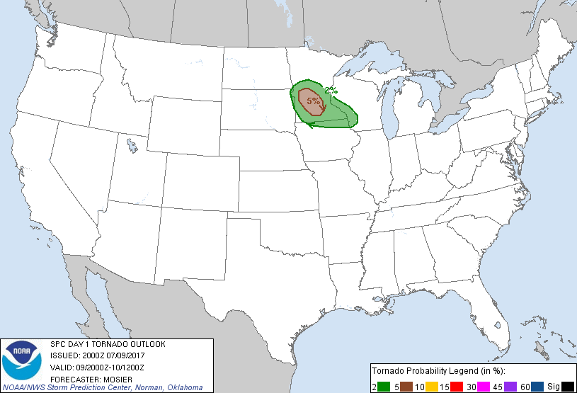
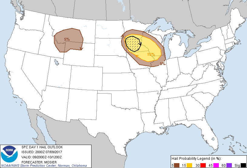
Strong instability and shear will support an initial supercellular
mode with all severe hazards, including a tornado or two, possible.
Close proximity of this development suggests a fast transition to a
linear mode with the resulting MCS then expected to track quickly
southeastward. Even with this quick transition, cells will likely
remain discrete long enough to merit 5% tornado probabilities, which
have been added across portions of central MN where the initial
development is anticipated.
...Southern Arizona...
Several strong storms have developed across the higher terrain of
far southeast AZ. These storms are expected to move westward and
will support the potential for a few strong wind gusts across the
lower desert. Only change to the previous outlook was to extend the
5% wind probabilities eastward to include the ongoing storms.
...Northern Rockies...
Scattered thunderstorms are still expected across the region with a
few of these storms capable of damaging wind gusts and hail. Refer
to MD 1268 for more information.
...Central TX southeastward to the LA coast...
Numerous thunderstorms have developed along the remnant outflow
boundary across central TX and along the sea breeze along the
southeast TX/southern LA coast. Warm and humid conditions are
supporting moderate instability and occasionally strong updrafts.
The lack of stronger shear should keep storms unorganized and
generally short-lived but storm mergers could result in updrafts
strong enough to produce damaging downburst. The 5% wind area was
extended back northwestward to include the ongoing activity across
portions of the TX Big Country.
..Mosier.. 07/09/2017
.PREV DISCUSSION... /ISSUED 1134 AM CDT Sun Jul 09 2017/
...Upper Mississippi Valley region...
Morning clouds and scattered weak convection over parts of the upper
Midwest are associated with a lead short wave trough moving across
the area. This is expected to shift eastward over the next few
hours in advance of a stronger perturbation evident in water vapor
imagery moving southeastward over far southern Manitoba. This
latter feature is forecast to progress into the upper Mississippi
Valley this afternoon and tonight contributing to an increased risk
of severe storms that will continue through much of the overnight
hours.
Low-level moisture is expected to increase northward into the region
this afternoon and evening as a southwest low-level jet strengthens
from western Iowa into southern Minnesota. A plume of steep
mid-level lapse rates is forecast to spread into the upper
Mississippi Valley this afternoon and contribute to an increasingly
unstable environment by later this afternoon and evening with MLCAPE
of 1500-3000 J/kg in place into the region.
Model guidance suggests the cap associated with the EML plume will
delay primary storm development until late this afternoon and
evening over parts of central Minnesota. Strong veering wind
profiles with height associated with the southwesterly low-level jet
and northwest flow in the mid/upper levels will result in 40-50 kt
deep layer shear, supportive of supercell characteristics in initial
discrete storms. Very large hail and a tornado or two will be
possible. With time the activity is expected to grow upscale into
one or two bowing QLCS systems that will accelerate southeastward
into the overnight hours. The primary severe risk is expected to
evolve into primarily a damaging wind threat tonight with potential
for one or more swaths of wind damage occurring across the immediate
Mississippi Valley region. A severe threat may persist through much
of the overnight hours and the severe risk areas have been extended
southeastward into northern parts of Illinois and Indiana to reflect
this scenario.
...Southern Arizona...
A modest weakening of the Four Corners vicinity upper-level ridge is
forecast today with expectations for somewhat weaker easterly
steering flow, in addition to what may be sub-optimally timed
ridge-peripheral disturbances. Even so, where isolated storms do
develop/slowly propagate this afternoon and evening, a hot/deeply
mixed boundary layer will support the possibility of locally strong
wind gusts and blowing dust, mainly across parts of
southern Arizona.
...Coastal portions of the Carolinas and Georgia...
Along and east of a weak slow-moving/stalling front, a moist air
mass featuring 70s F surface dewpoints and ample precipitable water
(in excess of 2 inches) will linger today mainly in coastal areas of
the Carolinas and southern Georgia. Heating and front/sea
breeze-related convergence aside, thunderstorm development will be
favorably influenced by cyclonic flow aloft. While
low/mid-tropospheric winds will be weak (less than 20 kt),
sufficiently steep low-level lapse rates and ample moisture
conducive for water loading could yield some strong to locally
severe downdrafts this afternoon/early evening.
...Portions of southern Plains/Ark-La-Tex to the Gulf Coast...
Pockets of locally stronger heating/destabilization should occur
today near and south of a convectively modulated/decaying front.
While overall forcing for ascent and vertical shear will remain
weak, sufficient moisture/destabilization could allow for a few
instances of downbursts capable of very localized wind damage.
...Northern Rockies...
A western states ridge-peripheral disturbance, in addition to height
falls over the Pacific Northwest, should influence thunderstorm
development across the region aside from adequate moisture and
orographic lift. Storms should initially develop and intensify this
afternoon across eastern Idaho/southwest Montana into western
Wyoming. Adequate moisture/buoyancy in the presence of as much as
25-35 kt of effective shear could yield a few instances of
marginally severe hail, while a relatively warm/well-mixed boundary
layer could support severe downdrafts this afternoon through early
evening.
CLICK TO GET WUUS01 PTSDY1 PRODUCT
NOTE: THE NEXT DAY 1 OUTLOOK IS SCHEDULED BY 0100Z