Minneapolis, MN...St. Paul, MN...Sioux Falls, SD...Duluth, MN...Bloomington, MN...
MARGINAL
379,321
6,423,092
Las Vegas, NV...Henderson, NV...Paradise, NV...Reno, NV...Sunrise Manor, NV...
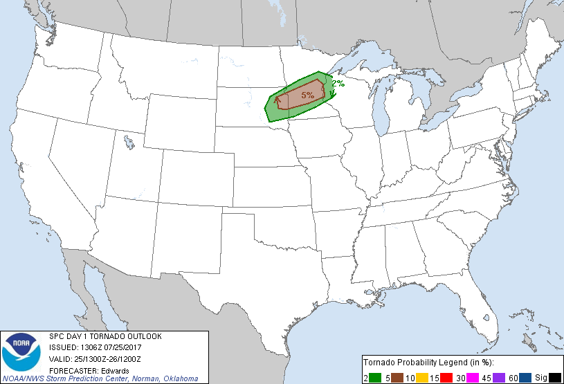
Probabilistic Tornado Graphic
Probability of a tornado within 25 miles of a point. Hatched Area: 10% or greater probability of EF2 - EF5 tornadoes within 25 miles of a point.
Day 1 Tornado Risk
Area (sq. mi.)
Area Pop.
Some Larger Population Centers in Risk Area
5 %
21,739
2,521,185
Minneapolis, MN...Plymouth, MN...Brooklyn Park, MN...Coon Rapids, MN...Maple Grove, MN...
2 %
32,113
1,965,569
St. Paul, MN...Bloomington, MN...Eagan, MN...Eden Prairie, MN...Burnsville, MN...
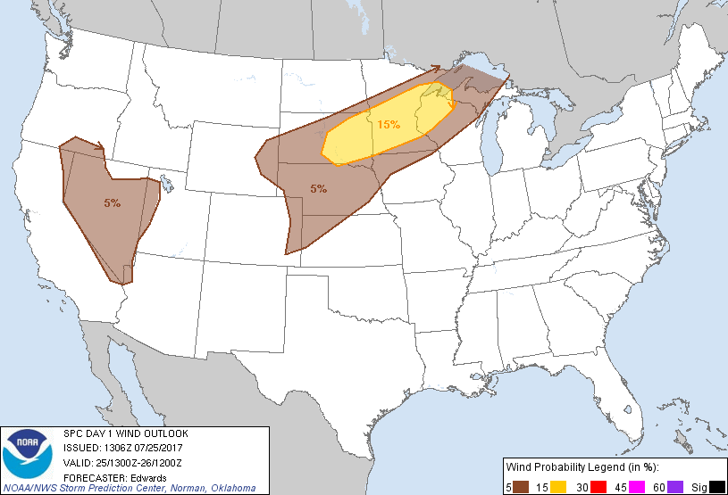
Probabilistic Damaging Wind Graphic
Probability of damaging thunderstorm winds or wind gusts of 50 knots or higher within 25 miles of a point. Hatched Area: 10% of greater probability of wind gusts 65 knots or greater within 25 miles of a point.
Day 1 Wind Risk
Area (sq. mi.)
Area Pop.
Some Larger Population Centers in Risk Area
15 %
91,981
5,469,014
Minneapolis, MN...St. Paul, MN...Sioux Falls, SD...Duluth, MN...Bloomington, MN...
5 %
357,442
6,090,392
Las Vegas, NV...Henderson, NV...Paradise, NV...Reno, NV...Sunrise Manor, NV...
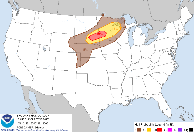
Probabilistic Large Hail Graphic
Probability of hail 1" or larger within 25 miles of a point. Hatched Area: 10% or greater probability of hail 2" or larger within 25 miles of a point.
Minneapolis, MN...St. Paul, MN...Sioux Falls, SD...Duluth, MN...Bloomington, MN...
5 %
208,765
2,881,734
Rochester, MN...Fargo, ND...Sioux City, IA...Rapid City, SD...La Crosse, WI...
SPC AC 251306
Day 1 Convective Outlook CORR 1
NWS Storm Prediction Center Norman OK
0806 AM CDT Tue Jul 25 2017
Valid 251300Z - 261200Z
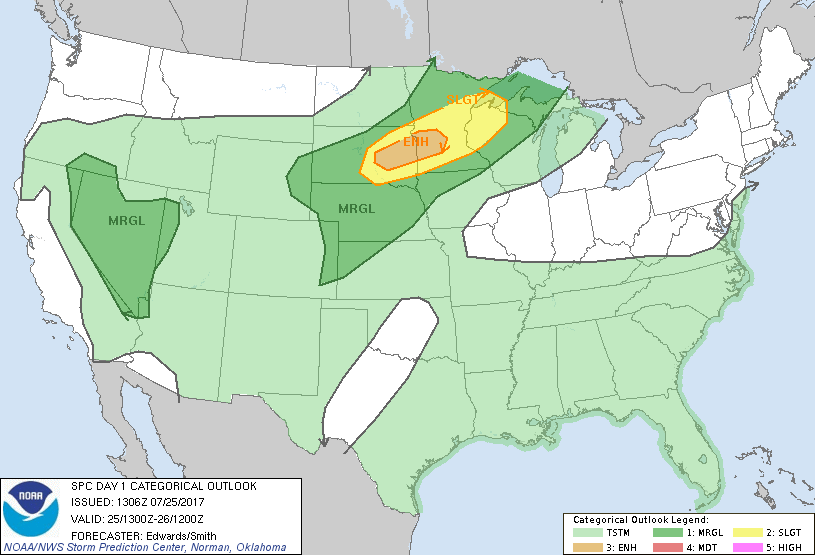
...THERE IS AN ENHANCED RISK OF SEVERE THUNDERSTORMS OVER PARTS OF
EASTERN SOUTH DAKOTA AND SOUTHWESTERN MINNESOTA...
...THERE IS A SLIGHT RISK OF SEVERE THUNDERSTORMS ELSEWHERE FROM
SOUTHERN SOUTH DAKOTA TO THE SOUTHWESTERN LAKE SUPERIOR AREA...
...THERE IS A MARGINAL RISK OF SEVERE THUNDERSTORMS SURROUNDING THE
SLIGHT RISK AND EXTENDING TO MUCH OF THE CENTRAL HIGH PLAINS...
...THERE IS A MARGINAL RISK OF SEVERE THUNDERSTORMS OVER THE WESTERN
GREAT BASIN REGION...
CORRECTED FOR WIND GRAPHIC
...SUMMARY...
Severe thunderstorms with damaging winds, large hail and the
possibility of tornadoes are forecast across portions of the
northern Plains and the Upper Mississippi Valley this afternoon and
evening. Isolated severe thunderstorm gusts also are possible over
parts of the Great Basin.
...Synopsis...
The northern-stream pattern aloft will become more zonal through the
period, as troughing exits the Northeast and weakens across the
downstream North Atlantic. A strong shortwave trough -- accompanied
by a compact mid/upper-level cyclone now located over the MB/SK
border -- is forecast to move eastward across much of northwestern
ON by the end of the period, with at least weak height falls
extending across much of MN/WI and Upper MI. A broad, messy area of
convectively generated/enhanced vorticity -- now evident in
moisture-channel imagery over parts of UT, western CO and eastern NV
-- will eject northeastward, evolving into a more distinct shortwave
trough over eastern SD and central NE by 12Z. Meanwhile, a
mid/upper low currently stationary over the northern CA coast will
remain so today, then begin to move eastward across northern CA late
tonight.
At the surface, a wavy frontal zone was analyzed from a low offshore
from the Mid-Atlantic across southern VA, KY, southern MO, and
northwestward generally up the Missouri Valley to another low in
central SD. Under weak flow aloft, disorganized general
thunderstorms will be possible near and south of the frontal zone
over the Southeast today. The western segment of the boundary will
move northeastward as a warm front through southern/central MN. A
weak/slow-moving cold front -- now extending from the SD low to
south-central WY -- will be overtaken from the northwest by a
stronger front initially positioned from northern ND to
southeastern/ south-central MT. By 12Z, the combined boundary
should extend from western Lake Superior across northern/western IA
to a frontal-wave low over south-central NE or north-central KS,
then southwestward to southeastern CO.
...Northern Plains to western Lake Superior Region...
Scattered thunderstorms are expected to develop late this afternoon
near the frontal zones, initially across southern and eastern SD,
then into southwestern/central/south-central MN, as a combination of
strong warm-sector heating and frontal convergence overcomes the
cap. Large hail is probable, along with at least isolated damaging
gusts. The cape/shear parameter space also supports a supercellular
tornado risk, though longevity of favorable storm mode is uncertain.
The 12Z ABR sounding sampled the base of a strong elevated mixed
layer, with robust basal inversion between 750-850 mb. Another
sounding is planned there at 18Z. This is partly to evaluate the
change in low-level thermodynamics through midday, including cap
strength and the progress of boundary-layer theta-e advection under
that cap, in the northern fringe of most focused severe
probabilities. Pending that and forthcoming 12Z model guidance, and
evaluating current diagnostics and prior/overnight progs, no major
changes to the prior outlook in this region are justified. Some
southward nudge of slight/enhanced probabilities is being done in
deference to the most probable corridor of afternoon storm
initiation near and east of the probable late-afternoon surface-low
position.
The air mass along and south of the frontal zones will destabilize
substantially from both insolation and low-level warm/moist
advection throughout the afternoon. Erosion of CINH should occur
preferentially over SD area where stronger/deeper mixing is likely.
Evapotranspirative augmentation of the moist-advection regime should
lead to a plume of upper 60s/low 70s F surface dew points east of
the low, combining with steep lapse rates aloft to support peak
preconvective MLCAPE 3000-4000 J/kg. Favorable low-level shear is
forecast, with SRH maximized near the warm front in eastern SD and
MN. Weaknesses in the midlevel hodograph may contribute to messy
storm modes after initial discrete to semi-discrete character. The
severe threat may persist northeastward tonight across parts of the
eastern MN/western WI/southwestern Lake Superior region in a regime
of favorable low-level warm advection near and north of the warm
front.
...Western Great Basin...
Widely scattered to scattered thunderstorms are expected to develop
this afternoon into early evening over higher terrain from the
eastern Sierras across the western Great Basin. Activity should
move mostly northward to northeastward over lower intermountain
terrain, where pockets of clearing permit enough insolation to
develop a well-mixed subcloud layer, in turn supporting a hybrid
wet/dry downburst thermodynamic configuration. While mid/upper-
level lapse rates are not forecast to be especially large,
sufficient low-level moisture in place to support weakly inhibited
MLCAPE in the 500-1500 J/kg range. A large area of difluent,
southwesterly to south-southwesterly flow will persist over the
region east of the slow-moving mid/upper-level low/trough. This
will occur beneath a belt of relatively maximized 250-mb to anvil-
level flow, contributing to both convective ventilation and
cloud-layer shear, though weak low-level winds are forecast. Lack
of both buoyancy and greater low/middle-level flow/shear preclude a
better-organized severe threat.
..Edwards.. 07/25/2017
CLICK TO GET WUUS01 PTSDY1 PRODUCT
NOTE: THE NEXT DAY 1 OUTLOOK IS SCHEDULED BY 1630Z