Des Moines, IA...Rockford, IL...Cedar Rapids, IA...Peoria, IL...Davenport, IA...
MARGINAL
154,721
20,661,055
Chicago, IL...Milwaukee, WI...Kansas City, MO...Omaha, NE...St. Louis, MO...
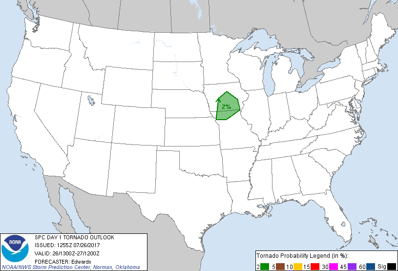
Probabilistic Tornado Graphic
Probability of a tornado within 25 miles of a point. Hatched Area: 10% or greater probability of EF2 - EF5 tornadoes within 25 miles of a point.
Day 1 Tornado Risk
Area (sq. mi.)
Area Pop.
Some Larger Population Centers in Risk Area
2 %
24,694
1,267,714
Des Moines, IA...St. Joseph, MO...Ames, IA...West Des Moines, IA...Ankeny, IA...
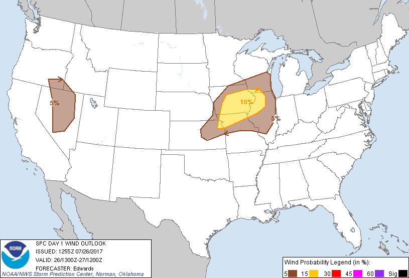
Probabilistic Damaging Wind Graphic
Probability of damaging thunderstorm winds or wind gusts of 50 knots or higher within 25 miles of a point. Hatched Area: 10% of greater probability of wind gusts 65 knots or greater within 25 miles of a point.
Day 1 Wind Risk
Area (sq. mi.)
Area Pop.
Some Larger Population Centers in Risk Area
15 %
63,936
4,452,265
Des Moines, IA...Rockford, IL...Cedar Rapids, IA...Peoria, IL...Davenport, IA...
5 %
154,429
20,710,389
Chicago, IL...Milwaukee, WI...Kansas City, MO...Omaha, NE...St. Louis, MO...
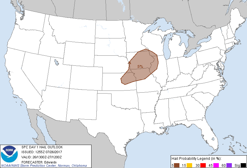
Probabilistic Large Hail Graphic
Probability of hail 1" or larger within 25 miles of a point. Hatched Area: 10% or greater probability of hail 2" or larger within 25 miles of a point.
Day 1 Hail Risk
Area (sq. mi.)
Area Pop.
Some Larger Population Centers in Risk Area
5 %
109,386
7,296,486
Kansas City, MO...Omaha, NE...Des Moines, IA...Overland Park, KS...Kansas City, KS...
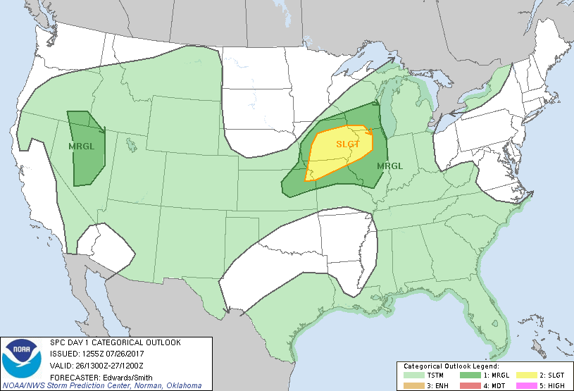
   SPC AC 261255

   Day 1 Convective Outlook
   NWS Storm Prediction Center Norman OK
   0755 AM CDT Wed Jul 26 2017

   Valid 261300Z - 271200Z

   ...THERE IS A SLIGHT RISK OF SEVERE THUNDERSTORMS FROM PARTS OF
   NORTHEASTERN KS TO SOUTHWESTERN WISCONSIN AND NORTHERN ILLINOIS...

   ...THERE IS A MARGINAL RISK OF SEVERE THUNDERSTORMS ELSEWHERE FROM
   CENTRAL KANSAS TO WESTERN INDIANA AND SOUTHERN/EASTERN WISCONSIN...

   ...THERE IS A MARGINAL RISK OF SEVERE THUNDERSTORMS OVER PARTS OF
   THE WESTERN GREAT BASIN...

   ...SUMMARY...
   Scattered thunderstorms, some with locally strong to severe wind
   gusts, are expected over portions of the Midwest and mid/upper
   Mississippi Valley regions this afternoon and evening.  Storms may
   also produce a few locally strong to damaging wind gusts over parts
   of the western Great Basin.

   ...Synopsis...
   The mid/upper level pattern will be categorized generally by:
   *  A zonally elongated anticyclone shifting westward from the
   southern plans across the southern Rockies;
   *  Height falls over much of the eastern U.S., as a series of
   shortwaves traverse a broad zone of troughing and associated
   cyclonic flow;
   *  A series of mostly low-amplitude shortwaves moving through a mean
   northern-stream ridge over the northern Rockies/northern High Plains
   region, and through downstream northwest flow aloft.

   The well-defined low aloft -- currently evident in moisture-channel
   imagery over northwestern CA, has begun to weaken and move
   east-northeastward in response to height falls over the northeastern
   Pacific.  This perturbation should devolve to an open wave through
   the remainder of the morning, continue gradual weakening, and slowly
   eject northeastward across northeastern CA and northwestern NV
   through the remainder of the period.  Meanwhile, a shortwave trough
   with convectively induced/enhanced vorticity maxima -- now located
   over the central Plains -- will move to near a DBQ-CNU axis by 00Z,
   then to an axis from southern IN to southeastern/south-central MO by
   12Z.

   At the surface, a cold front was analyzed from a cyclone over far
   northern ON southwestward across the MN Arrowhead, southwestern MN,
   to central NE, through a weak frontal-wave low over the HLC-MCK
   region, to southeastern CO.  Outflow boundaries preceded this front
   from IA to central KS.  The front should shift eastward to eastern
   Lake Superior, southeastern IA, through a low over the TOP/MKC
   region, to the OK Panhandle by 00z, again preceded by outflows.  By
   12Z, the front should reach Lake Huron, northern/western IL, central
   MO, southern KS, and the TX Panhandle.

   ...Midwest...
   Ongoing, initially non-severe convection is evident in an extensive
   complex from western IA south-southwestward across extreme
   southeastern NE to portions of central/northeastern KS.  A separate
   area of elevated thunderstorms is evident within the rim of a
   warm-advection plume over parts of WI.  These morning convective
   clusters are expected to move eastward with general weakening
   through midday.  However, some redevelopment or re-intensification
   of embedded elements is possible to the east of their current
   positions from midday into afternoon as the associated plume of UVV
   impinges on a boundary layer slowly destabilizing from a combination
   of WAA and cloud-muted diabatic heating.  Additional convection may
   develop over western parts of the outlook area near the front, in
   the wake of the morning convection/precip, yielding a conditional
   wind/hail threat.  A combination of the two potential regimes, with
   considerable spatial overlap, yields the outlook area as a whole.

   Uncertainties exist regarding the duration and magnitude of
   supportive destabilization (especially with northward extent) behind
   the morning activity, whose pace of weakening and of eastward
   movement will be important.  Where sustained surface heating can
   occur, forecast soundings suggest 1500-2000 J/kg MLCAPE is possible,
   locally near 3000 J/kg where deep-layer flow aloft will be somewhat
   weaker in the southwestern parts of the outlook area.  Mesoscale
   enhancement to deep shear and large-scale ascent will be possible,
   aiding the potential for organized multicell structures, small bows,
   and perhaps messy/heavy-precip supercell types of generally short
   longevity.  Effective-shear magnitudes 25-40 kt are common in
   forecast soundings.  Outflow and differential-heating zones yet to
   be determined will play a major role in focusing the prefrontal and
   frontal severe threats more precisely across this region.

   ...Western Great Basin...
   Widely scattered thunderstorms are expected to develop again this
   afternoon over the western/central parts of the outlook area.
   Activity should move generally northeastward over patches of
   boundary-layer air heated enough to yield favorably well-mixed
   subcloud thermodynamic profiles, beneath about 500-800 J/kg MLCAPE.
   The main concern will be isolated severe/damaging gusts.  The area
   will reside under difluent flow aloft and subtle large-scale
   ascent/destabilization in midlevels ahead of the ejecting northern
   CA perturbation, in support of convective potential.

   ..Edwards/Smith.. 07/26/2017

   CLICK TO GET WUUS01 PTSDY1 PRODUCT

   NOTE: THE NEXT DAY 1 OUTLOOK IS SCHEDULED BY 1630Z