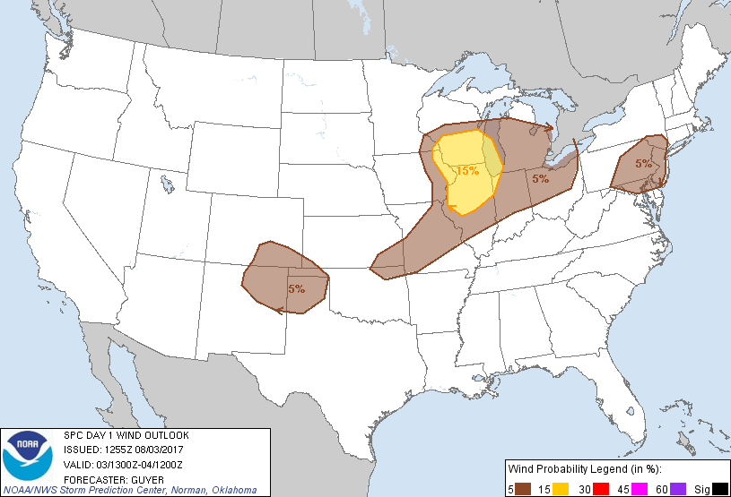
Probability of damaging thunderstorm winds or wind gusts of 50 knots or higher within 25 miles of a point. Hatched Area: 10% of greater probability of wind gusts 65 knots or greater within 25 miles of a point.
Colorado Springs, CO...St. Louis, MO...Grand Rapids, MI...Amarillo, TX...Springfield, MO...
SPC AC 031255
Day 1 Convective Outlook
NWS Storm Prediction Center Norman OK
0755 AM CDT Thu Aug 03 2017
Valid 031300Z - 041200Z
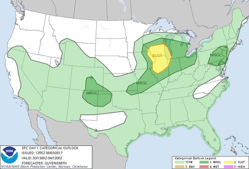
...THERE IS A SLIGHT RISK OF SEVERE THUNDERSTORMS ACROSS PARTS OF
THE MIDWEST...
...THERE IS A MARGINAL RISK OF SEVERE THUNDERSTORMS ACROSS THE
MIDWEST AND LOWER MO RIVER VALLEY TO GREAT LAKES...
...THERE IS A MARGINAL RISK OF SEVERE THUNDERSTORMS ACROSS THE
MID-ATLANTIC/NORTHEAST STATES...
...THERE IS A MARGINAL RISK OF SEVERE THUNDERSTORMS ACROSS THE
SOUTH-CENTRAL HIGH PLAINS...
...SUMMARY...
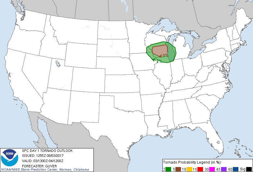
Severe thunderstorms are possible this afternoon and evening across
far eastern Iowa, southeast Minnesota into central and southern
Wisconsin and northern Illinois, including the potential for a
tornado or two. Other strong to severe storms are possible across
other parts of the Midwest, Northeast states, and over the
south-central High Plains.
...Portions of IA/MN/IL/WI...
A shortwave trough over the eastern Dakotas and western MN early
this morning will continue to amplify and eventually close off as it
digs east-southeastward toward the upper MS River Valley through
tonight, with downstream height falls overspreading much of the
Midwest and Great Lake region. In response, a surface low will
steadily deepen as it shifts east-northeastward from IA/southern MN
into WI ahead of an east/southeastward-moving cold front.
Scattered showers/thunderstorms and semi-prevalent cloud cover early
today casts uncertainty regarding the overall degree of
destabilization within the warm sector ahead of the cold front and
near/south of a northward-shifting warm front. Even so, it appears
that a semi-focused supercell risk, including the potential for a
couple of tornadoes, could materialize especially across
south-central WI later this afternoon into early evening ahead of
the deepening surface low and the preceding northward-shifting warm
front. Within this corridor, low-level shear/SRH will be maximized
with moderately long/curved low-level hodographs with 0-1 km SRH as
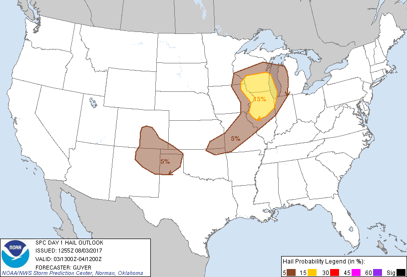
high as 150-200 m2/s2. Bouts of severe hail and damaging winds will
otherwise be possible.
Otherwise, isolated thunderstorms are expected to develop along the
trailing cold front across eastern IA into northeast MO. This
activity should propagate into IL ahead of strengthening mid-level
jet. Large hail and damaging winds are possible with this convection
as it spreads into a pre-frontal instability axis with fairly steep
low-level lapse rates.
...South-central High Plains...
Strong boundary-layer heating across the southern High Plains should
remove convective inhibition along a southward-surging cold front
near the NM/CO border with low-level upslope trajectories also
increasing near the front range. Isolated convection is expected to
develop over the higher terrain then drift southeast within a
northwesterly flow regime. Gusty winds and hail are the primary
threats with this activity as it spreads toward the TX Panhandle.
...Mid-Atlantic/Northeast States...
Upper heights will weakly rise today with only weak tropospheric
winds and somewhat warmer mid-level temperatures (-9 to -10C at 500
mb) as compared to yesterday. That said, as thunderstorms increase
in coverage this afternoon, relatively steep low-level lapse rates
and areas of moderate buoyancy could allow for some stronger
pulse-type storms capable of localized tree damage.
..Guyer/Smith.. 08/03/2017
CLICK TO GET WUUS01 PTSDY1 PRODUCT
NOTE: THE NEXT DAY 1 OUTLOOK IS SCHEDULED BY 1630Z