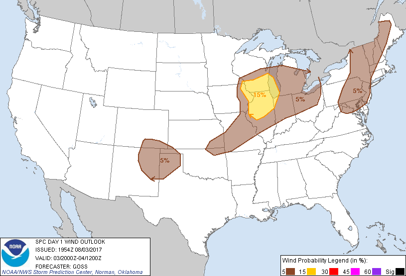
Probability of damaging thunderstorm winds or wind gusts of 50 knots or higher within 25 miles of a point. Hatched Area: 10% of greater probability of wind gusts 65 knots or greater within 25 miles of a point.
St. Louis, MO...Grand Rapids, MI...Cedar Rapids, IA...South Bend, IN...Green Bay, WI...
SPC AC 031954
Day 1 Convective Outlook
NWS Storm Prediction Center Norman OK
0254 PM CDT Thu Aug 03 2017
Valid 032000Z - 041200Z
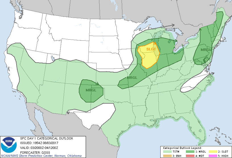
...THERE IS A SLIGHT RISK OF SEVERE THUNDERSTORMS ACROSS PORTIONS OF
THE MIDWEST AND SOUTHERN PARTS OF THE UPPER GREAT LAKES AREA...
...THERE IS A MARGINAL RISK OF SEVERE THUNDERSTORMS SURROUNDING THE
SLIGHT RISK...AND EXTENDING EAST TO OHIO AND SOUTHWEST TO SOUTHEAST
KANSAS/NORTHEAST OKLAHOMA...
...THERE IS A MARGINAL RISK OF SEVERE THUNDERSTORMS ACROSS PORTIONS
OF THE NORTHEAST...
...THERE IS A MARGINAL RISK OF SEVERE THUNDERSTORMS ACROSS PARTS OF
THE SOUTHERN HIGH PLAINS...
...SUMMARY...
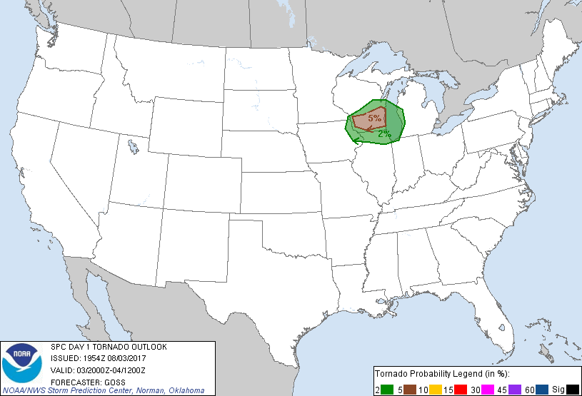
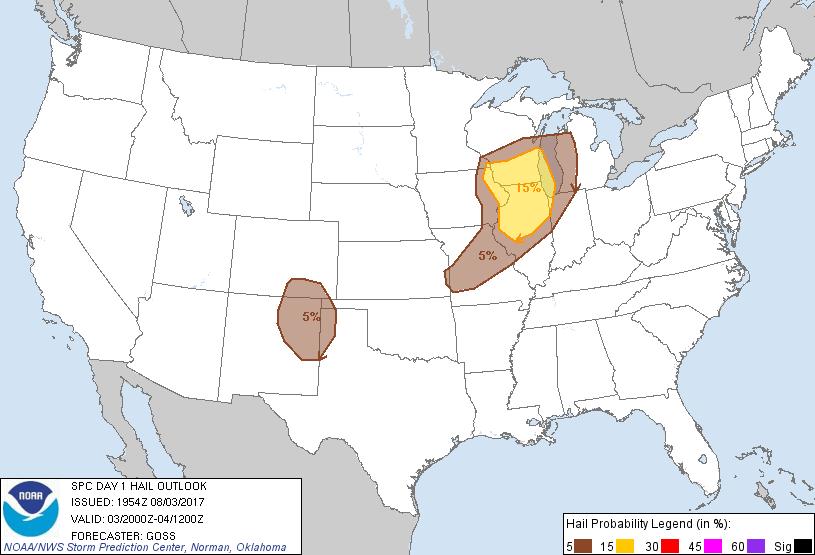
Severe thunderstorms are possible this afternoon and evening from
eastern Iowa to southern Wisconsin and northern Illinois, including
the potential for a tornado or two. Other strong to severe storms
are possible across other parts of the Midwest, Northeast states,
and over the south-central High Plains.
...Discussion...
Prior forecast reasoning remains valid this afternoon, with little
need for change evident in general. Some adjustment to thunder
lines is being implemented at this time, mainly over the Wyoming
vicinity and parts of southwest Texas. The severe risk area across
the upper Midwest is also being adjusted slightly on the northern
and western fringes, based on current trends. Otherwise,
appreciable changes do not appear to be required at this time.
..Goss.. 08/03/2017
.PREV DISCUSSION... /ISSUED 1115 AM CDT Thu Aug 03 2017/
...Upper Midwest/Great Lakes through late evening...
A midlevel shortwave trough over MN/IA will progress
east-southeastward to WI/IL by tonight. The midlevel trough will
amplify some in conjunction with a deepening surface cyclone that is
expected to move from northeast IA to the northern Lake MI vicinity
by Friday morning. A trailing cold front will move southeastward
across IA/IL/MO/KS through this evening, and a warm front will
develop northward across WI as the cyclone deepens.
A band of pre-frontal convection is ongoing across eastern IA, in
the zone of ascent preceding the midlevel trough to the west.
Surface heating/destabilization in advance of this convection could
result in some intensification of the storms this afternoon across
northern IL and southern WI. There will also be some potential for
new storm development along the cold front and in the wake of the
morning storms, assuming sufficient recovery can occur this
afternoon. MLCAPE values of 1500-2000 J/kg and some increase in
vertical shear (mainly close to the surface low and along the warm
front) will support a threat for organized clusters/line segments,
and potentially a couple of supercells. Large hail and damaging
winds will be the main threats this afternoon/evening, though a
tornado or two could occur if supercells can interact with the zone
of stronger low-level shear along the warm front in southern WI.
...Mid Atlantic to New England this afternoon...
Scattered diurnal convection is expected again this afternoon across
this corridor, with initial development focused primarily by local
terrain features. Vertical shear remains weak, and buoyancy will
likely be reduced some compared to yesterday, but the strongest
storms will still pose a threat for isolated downbursts, and
generally sub-severe hail.
...Southern High Plains this afternoon/evening...
An upslope flow regime will develop this afternoon from southeast CO
into northeast NM along a cold front moving southward from eastern
CO and KS. This front will also reside along the southern fringe of
the midlevel west-northwesterly flow, with subtle embedded speed
maxima moving from the northern Great Basin to the High Plains.
Pockets of surface heating in cloud breaks will contribute to
moderate buoyancy (MLCAPE of 1000-1500 J/kg), while vertical shear
will be sufficient for some organization of storm clusters, and
perhaps a couple of supercells early in the storm evolution.
Isolated strong outflow gusts and hail will be the main threats.
CLICK TO GET WUUS01 PTSDY1 PRODUCT
NOTE: THE NEXT DAY 1 OUTLOOK IS SCHEDULED BY 0100Z