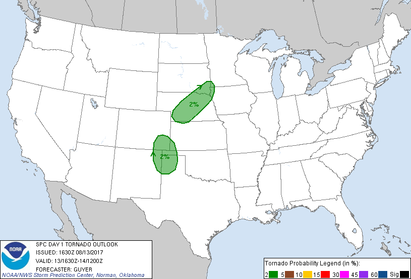
Amarillo, TX...Sioux Falls, SD...Sioux City, IA...Grand Island, NE...Clovis, NM...
MARGINAL
187,159
8,202,481
Denver, CO...Colorado Springs, CO...Aurora, CO...Lubbock, TX...Shreveport, LA...
Probabilistic Tornado Graphic
Probability of a tornado within 25 miles of a point. Hatched Area: 10% or greater probability of EF2 - EF5 tornadoes within 25 miles of a point.
Day 1 Tornado Risk
Area (sq. mi.)
Area Pop.
Some Larger Population Centers in Risk Area
2 %
84,473
1,344,993
Amarillo, TX...Sioux Falls, SD...Sioux City, IA...Grand Island, NE...Kearney, NE...
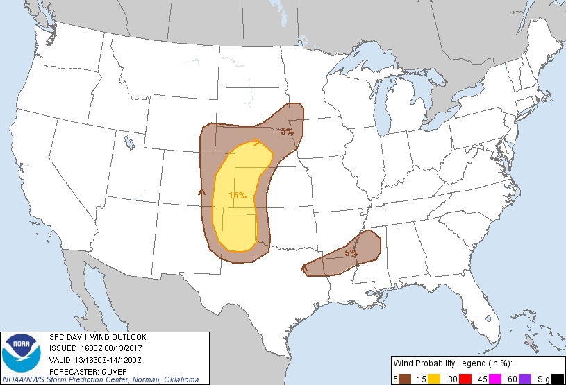
Probabilistic Damaging Wind Graphic
Probability of damaging thunderstorm winds or wind gusts of 50 knots or higher within 25 miles of a point. Hatched Area: 10% of greater probability of wind gusts 65 knots or greater within 25 miles of a point.
Day 1 Wind Risk
Area (sq. mi.)
Area Pop.
Some Larger Population Centers in Risk Area
15 %
118,772
1,064,985
Amarillo, TX...Grand Island, NE...Clovis, NM...Kearney, NE...Garden City, KS...
5 %
208,137
8,774,956
Denver, CO...Colorado Springs, CO...Aurora, CO...Lubbock, TX...Shreveport, LA...
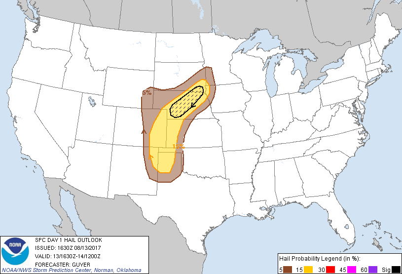
Probabilistic Large Hail Graphic
Probability of hail 1" or larger within 25 miles of a point. Hatched Area: 10% or greater probability of hail 2" or larger within 25 miles of a point.
Day 1 Hail Risk
Area (sq. mi.)
Area Pop.
Some Larger Population Centers in Risk Area
SIG SEVERE
24,905
199,163
North Platte, NE...Yankton, SD...Lexington, NE...Vermillion, SD...
15 %
127,065
1,584,333
Amarillo, TX...Sioux Falls, SD...Sioux City, IA...Grand Island, NE...Kearney, NE...
5 %
131,681
5,568,648
Denver, CO...Colorado Springs, CO...Aurora, CO...Lubbock, TX...Lakewood, CO...
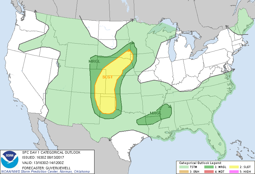
   SPC AC 131630

   Day 1 Convective Outlook
   NWS Storm Prediction Center Norman OK
   1130 AM CDT Sun Aug 13 2017

   Valid 131630Z - 141200Z

   ...THERE IS A SLIGHT RISK OF SEVERE THUNDERSTORMS FROM THE MIDDLE MO
   VALLEY TO THE CENTRAL AND SOUTHERN HIGH PLAINS...

   ...THERE IS A MARGINAL RISK OF SEVERE THUNDERSTORMS FROM THE MIDDLE
   MO VALLEY/UPPER MIDWEST TO THE CENTRAL AND SOUTHERN HIGH PLAINS...

   ...THERE IS A MARGINAL RISK OF SEVERE THUNDERSTORMS FROM THE
   ARKLATEX TO THE ARKLAMISS...

   ...SUMMARY...
   Scattered severe storms are expected from the Mid-Missouri Valley to
   the central and southern High Plains this afternoon and evening.
   Large hail, damaging winds, and a tornado or two are possible.

   ...Middle MO Valley and Central/Southern High Plains...
   A shortwave trough centered over the eastern Dakotas and
   west-central MN late this morning will continue to drift
   east-southeastward through tonight with a weak surface cyclone over
   south-central SD also moving eastward. Isolated to widely scattered
   storms will develop late afternoon near the cyclone, along the
   trough, and off the Front Range.

   Lower to middle 60s surface dew points on the periphery of steep
   mid-level lapse rates will yield a plume of large buoyancy with
   MLCAPE reaching 1500-3000 J/kg at peak heating. 30-40 kt 500-mb
   westerlies will be most pervasive across southeast SD and NE, where
   the greatest potential for a few supercells producing very large
   hail and a tornado should exist along the
   northeast/southwest-oriented surface trough. Activity in this region
   should weaken by midnight with only a modest increase in low-level
   warm advection during the evening.

   Farther south, additional development is expected near/east of the
   Sangre De Cristos and Raton Mesa vicinities late afternoon. This
   activity may congeal into an MCS towards the TX Panhandle during the
   evening given a plume of upper 60s surface dew points persisting in
   northwest TX. Mixed hazards of large hail and severe gusts are
   possible. In spite of a nocturnal low-level jet, the severe threat
   should wane overnight given negative theta-e advection from the
   south.

   ...ArkLaTex to ArkLaMiss...
   An MCV continues to move eastward across the ArkLaTex region as of
   late morning, with related convection extending as far east as
   northwest MS coincident with a prevalent cloud canopy. Somewhat
   greater insolation is occurring across central portions of LA/MS
   into AL. Additional storm development seems likely this afternoon as
   the boundary layer continues to warm and the MCV continues eastward.
   Although deep-layer shear should be modest, water-loaded downdrafts
   amid a cluster mode may yield isolated strong wind gusts and tree
   damage.

   ...Carolinas/Eastern Georgia...
   A moist and unstable air mass will exist this afternoon especially
   across the Piedmont/coastal portions of the Carolinas into eastern
   GA in areas along and south of a front. As storms develop/increase
   this afternoon with aid of the front and sea breeze circulations, a
   few stronger storms may occur as low-level lapse rates steepen. That
   said, the influences of gradually rising upper heights and warm
   mid-level temperatures are expected to temper updraft vigor such
   that any potential for damaging downbursts should remain quite
   localized this afternoon.

   ..Guyer/Jewell.. 08/13/2017

   CLICK TO GET WUUS01 PTSDY1 PRODUCT

   NOTE: THE NEXT DAY 1 OUTLOOK IS SCHEDULED BY 2000Z