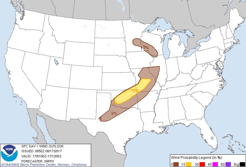
Probability of damaging thunderstorm winds or wind gusts of 50 knots or higher within 25 miles of a point. Hatched Area: 10% of greater probability of wind gusts 65 knots or greater within 25 miles of a point.
Day 1 Wind Risk
Area (sq. mi.)
Area Pop.
Some Larger Population Centers in Risk Area
15 %
45,155
4,155,083
Oklahoma City, OK...Tulsa, OK...Springfield, MO...Norman, OK...Lawton, OK...
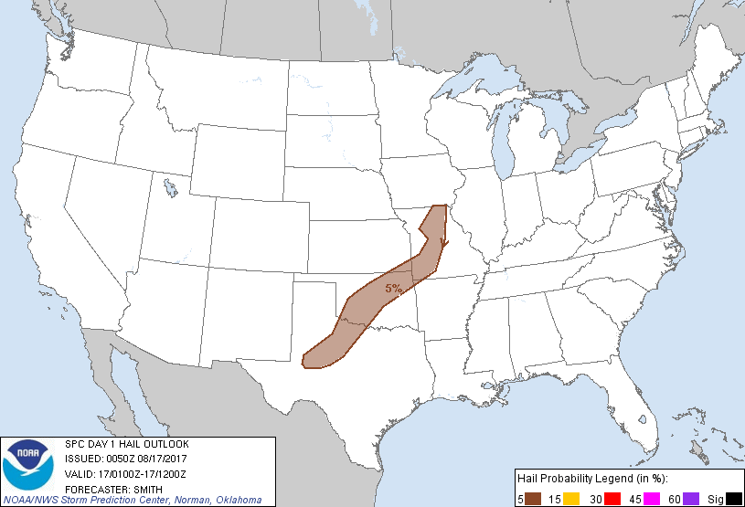
Probability of hail 1" or larger within 25 miles of a point. Hatched Area: 10% or greater probability of hail 2" or larger within 25 miles of a point.
Day 1 Hail Risk
Area (sq. mi.)
Area Pop.
Some Larger Population Centers in Risk Area
5 %
80,397
5,109,218
Oklahoma City, OK...Tulsa, OK...Springfield, MO...Abilene, TX...Norman, OK...
SPC AC 170050
Day 1 Convective Outlook
NWS Storm Prediction Center Norman OK
0750 PM CDT Wed Aug 16 2017
Valid 170100Z - 171200Z
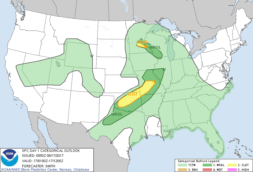
...THERE IS A SLIGHT RISK OF SEVERE THUNDERSTORMS NEAR THE I-44
CORRIDOR EXTENDING FROM SOUTHWESTERN OKLAHOMA INTO CENTRAL
MISSOURI...
...THERE IS A SLIGHT RISK OF SEVERE THUNDERSTORMS FOR A SMALL
PORTION OF SOUTHEAST MINNESOTA...
...THERE IS A MARGINAL RISK OF SEVERE THUNDERSTORMS FROM PORTIONS OF
TEXAS NORTHEASTWARD INTO THE LOWER MISSOURI VALLEY...
...THERE IS A MARGINAL RISK OF SEVERE THUNDERSTORMS FROM SOUTHERN
MINNESOTA INTO SOUTHWESTERN WISCONSIN...
...SUMMARY...
Isolated to scattered severe gusts are possible this evening from
Oklahoma into central Missouri, and this risk will linger into the
overnight hours as it moves eastward into the Ozarks and eastern
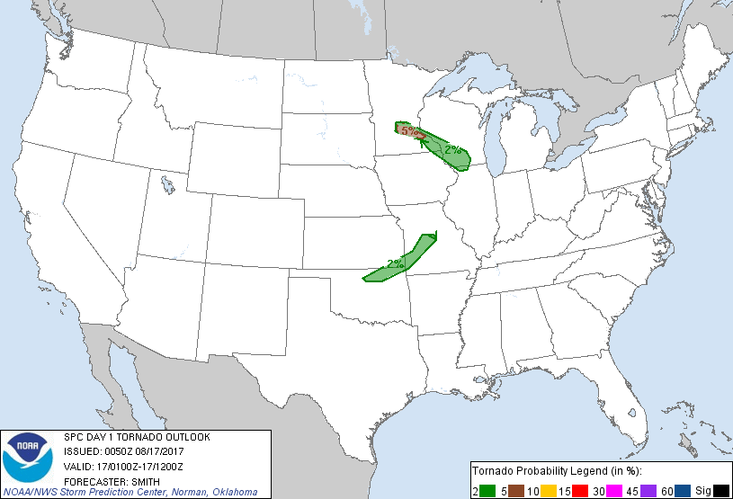
Oklahoma. An early evening risk for a tornado will generally be
confined across parts of southeast Minnesota.
...Southern Plains into the lower Missouri Valley...
Early evening subjective surface mesoanalysis places a
southeastward-moving front from eastern KS into northwest TX. A
very moisture-rich airmass ahead of the boundary has contributed to
a moderately unstable boundary layer. Storm development has
zippered southwest along the front into a linear band this evening.
The primary severe risk with the activity over OK northeast into the
lower MO Valley will be severe gusts resulting in wind damage. The
threat for wind damage will slowly decrease but the maintenance of
35-kt southwesterly 850-mb flow from eastern OK into east-central MO
will aid in theta-e advection and squall line longevity late into
tonight. Additionally, a marginal risk for large hail may continue
in the short term before nocturnal stabilization serves to weaken
updraft intensity.
...Southern Minnesota and southwest Wisconsin...
A potent shortwave trough will continue to migrate northeast towards
the Upper Midwest tonight. An isolated severe risk may continue in
the short term but diminish generally after sunset with the loss of
instability. In the meantime, enlarged hodographs in a warm frontal
zone extending from a surface low in southern MN east-southeastward
into southern WI may support a couple of supercells capable of an
isolated risk for a weak/brief tornado for another hour or two.
..Smith.. 08/17/2017
CLICK TO GET WUUS01 PTSDY1 PRODUCT
NOTE: THE NEXT DAY 1 OUTLOOK IS SCHEDULED BY 0600Z