Houston, TX...Pasadena, TX...Sioux Falls, SD...Sugar Land, TX...Missouri City, TX...
MARGINAL
91,681
3,624,200
Corpus Christi, TX...Beaumont, TX...Sioux City, IA...College Station, TX...The Woodlands, TX...
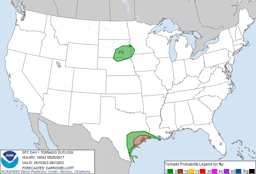
Probabilistic Tornado Graphic
Probability of a tornado within 25 miles of a point. Hatched Area: 10% or greater probability of EF2 - EF5 tornadoes within 25 miles of a point.
Day 1 Tornado Risk
Area (sq. mi.)
Area Pop.
Some Larger Population Centers in Risk Area
5 %
10,562
5,263,174
Houston, TX...Pasadena, TX...Sugar Land, TX...Missouri City, TX...Baytown, TX...
2 %
57,293
3,251,978
Corpus Christi, TX...Sioux Falls, SD...Beaumont, TX...College Station, TX...The Woodlands, TX...
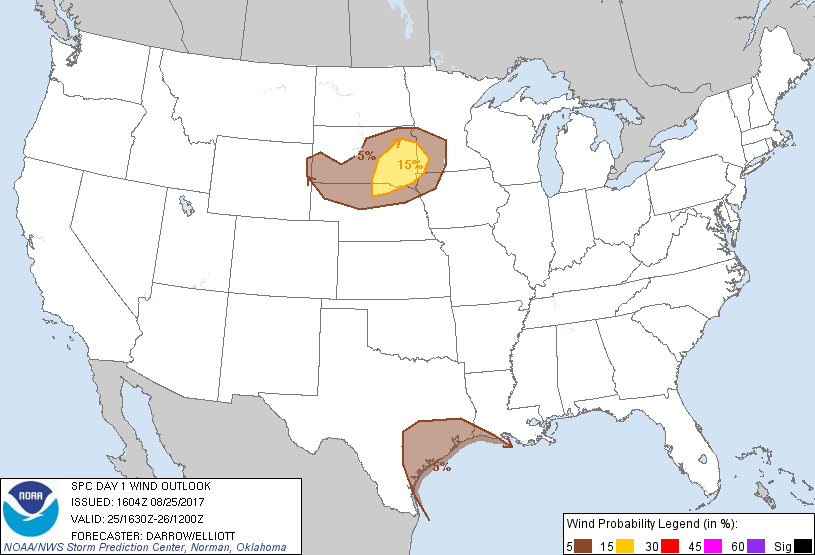
Probabilistic Damaging Wind Graphic
Probability of damaging thunderstorm winds or wind gusts of 50 knots or higher within 25 miles of a point. Hatched Area: 10% of greater probability of wind gusts 65 knots or greater within 25 miles of a point.
Day 1 Wind Risk
Area (sq. mi.)
Area Pop.
Some Larger Population Centers in Risk Area
15 %
27,183
518,772
Sioux Falls, SD...Watertown, SD...Brookings, SD...Mitchell, SD...Yankton, SD...
5 %
110,133
8,999,991
Houston, TX...Corpus Christi, TX...Pasadena, TX...Beaumont, TX...Sioux City, IA...
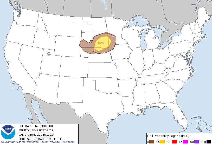
Probabilistic Large Hail Graphic
Probability of hail 1" or larger within 25 miles of a point. Hatched Area: 10% or greater probability of hail 2" or larger within 25 miles of a point.
Day 1 Hail Risk
Area (sq. mi.)
Area Pop.
Some Larger Population Centers in Risk Area
15 %
34,404
547,518
Sioux Falls, SD...Watertown, SD...Brookings, SD...Mitchell, SD...Yankton, SD...
5 %
65,460
923,546
Sioux City, IA...Rapid City, SD...Norfolk, NE...Aberdeen, SD...Willmar, MN...
SPC AC 251604
Day 1 Convective Outlook
NWS Storm Prediction Center Norman OK
1104 AM CDT Fri Aug 25 2017
Valid 251630Z - 261200Z
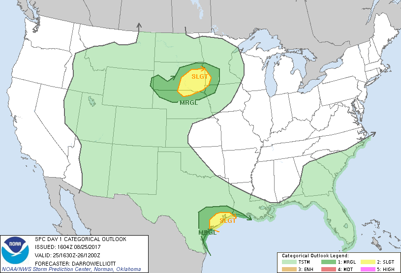
...THERE IS A SLIGHT RISK OF SEVERE THUNDERSTORMS ALONG THE MIDDLE
AND UPPER TX COAST...
...THERE IS A SLIGHT RISK OF SEVERE THUNDERSTORMS ACROSS PORTIONS OF
THE NORTHERN PLAINS...
...THERE IS A MARGINAL RISK OF SEVERE THUNDERSTORMS ACROSS THE
COASTAL PLAIN OF TX...
...THERE IS A MARGINAL RISK OF SEVERE THUNDERSTORMS ACROSS PORTIONS
OF THE NORTHERN PLAINS...
...SUMMARY...
Tornadoes and locally damaging winds are possible today and tonight
with stronger cells mainly north through northeast of the center of
Hurricane Harvey. Otherwise, a cluster of thunderstorms should
develop across parts of South Dakota and northern Nebraska, offering
locally damaging winds and/or hail during the afternoon and evening.
...Harvey...
Hurricane Harvey, currently located roughly 70 mi off the lower TX
coast, continues its slow northwest movement toward the middle TX
coast. Stronger outer bands are beginning to affect near-coastal
regions and supercell structures should become more common later
this afternoon/evening, especially along the upper TX coast where
buoyancy is expected to be greater. Tornado threat will increase as
these stronger structures move inland. Ref MCD #1564 for more
details regarding the tornado threat and NHC for more information on
Hurricane Harvey.
...Northern/Central Plains...
Long-lived MCV, from overnight convection, has shifted across
southeast MT/northeast WY to near Y22 along the ND/SD border.
Considerable amount of clouds currently extend from the south side
of the Black Hills into northeast SD north of the wind shift but
strong surface heating is expected to persist across the warm
sector. Latest short-range guidance suggests surface temperatures
will warm to near 90F across north-central NE into south-central SD
which should be adequate for CIN reduction necessary for
surface-based thunderstorm development near the boundary (likely
after 22z). Latest HRRR guidance supports this scenario with
southwest-northeast oriented boundary becoming convectively active
by late afternoon. Additionally, low-level warm advection should
encourage thunderstorm activity downstream into southwest MN. Only
minor changes have been made to the 13z outlook, namely to extend 5%
severe probs toward the south side of the Black Hills where upslope
flow may contribute to isolated strong thunderstorms later this
afternoon that would shift southeast toward the NE border.
..Darrow/Elliott.. 08/25/2017
CLICK TO GET WUUS01 PTSDY1 PRODUCT
NOTE: THE NEXT DAY 1 OUTLOOK IS SCHEDULED BY 2000Z