Chicago, IL...Phoenix, AZ...Tucson, AZ...Kansas City, MO...Mesa, AZ...
Probabilistic Tornado Graphic
Probability of a tornado within 25 miles of a point. Hatched Area: 10% or greater probability of EF2 - EF5 tornadoes within 25 miles of a point.
Day 1 Tornado Risk
Area (sq. mi.)
Area Pop.
Some Larger Population Centers in Risk Area
2 %
41,359
10,852,471
Detroit, MI...Toledo, OH...Fort Wayne, IN...Warren, MI...Sterling Heights, MI...
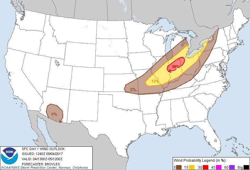
Probabilistic Damaging Wind Graphic
Probability of damaging thunderstorm winds or wind gusts of 50 knots or higher within 25 miles of a point. Hatched Area: 10% of greater probability of wind gusts 65 knots or greater within 25 miles of a point.
Day 1 Wind Risk
Area (sq. mi.)
Area Pop.
Some Larger Population Centers in Risk Area
30 %
18,202
2,285,048
Fort Wayne, IN...Muncie, IN...Lafayette, IN...Anderson, IN...Carmel, IN...
Chicago, IL...Detroit, MI...Columbus, OH...Kansas City, MO...Cleveland, OH...
SPC AC 041240
Day 1 Convective Outlook
NWS Storm Prediction Center Norman OK
0740 AM CDT Mon Sep 04 2017
Valid 041300Z - 051200Z
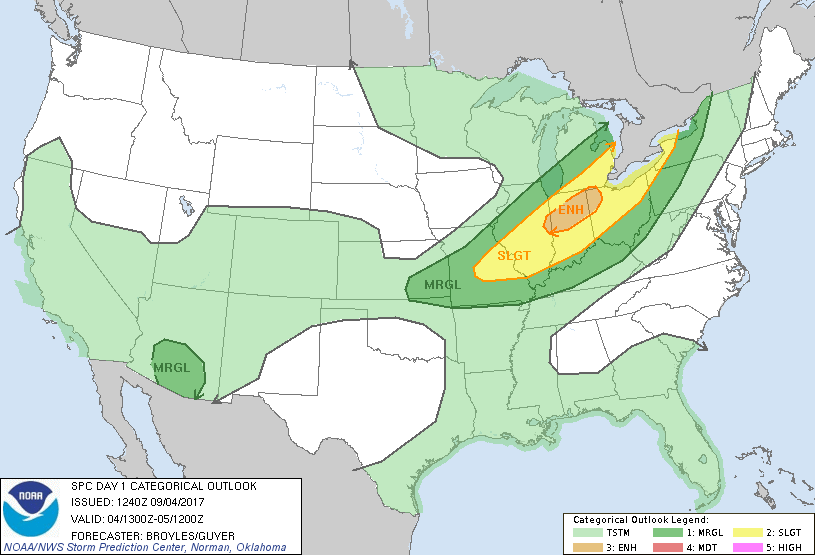
...THERE IS AN ENHANCED RISK OF SEVERE THUNDERSTORMS ACROSS PARTS OF
FAR EASTERN ILLINOIS...NORTH-CENTRAL INDIANA...NORTHWEST OHIO AND
FAR SOUTHERN LOWER MICHIGAN...
...THERE IS A SLIGHT RISK OF SEVERE THUNDERSTORMS OUTSIDE OF THE
ENHANCED RISK AREA FROM THE MID MISSISSIPPI VALLEY NORTHEASTWARD
INTO THE LOWER GREAT LAKES...
...THERE IS A MARGINAL RISK OF SEVERE THUNDERSTORMS OUTSIDE OF THE
SLIGHT RISK AREA FROM SOUTHEAST KANSAS AND FAR NORTHEAST OKLAHOMA
NORTHEASTWARD INTO THE LOWER GREAT LAKES AND NORTHEAST...
...THERE IS A MARGINAL RISK OF SEVERE THUNDERSTORMS ACROSS PARTS OF
SOUTHERN AND CENTRAL ARIZONA...
...SUMMARY...
Severe thunderstorms are likely across the lower Great Lakes and
Ohio Valley region, perhaps as far southwest as southeast Kansas,
this afternoon and evening. Additional strong storms may impact the
higher terrain and lower deserts of central and southern Arizona.
...Lower Great Lakes/Ohio Valley/Mid Mississippi Valley/Central
Plains...
An upper-level trough will dig quickly southeastward into the Upper
Mississippi Valley today. A broad belt of west to west-southwesterly
cyclonic flow will be in place ahead of the trough across much of
the Great Lakes and Ohio Valley. At the surface, a cold front will
advance southeastward today across the central Great Lakes, upper to
mid Mississippi Valley and central Plains. A few thunderstorms
should be ongoing along the front this morning. Ahead of the front,
surface dewpoints are forecast to increase into the mid to upper 60s
F by this afternoon. This combined with warming surface
temperatures should result in the development of moderate
instability. Moderate instability is expected to first develop in
the mid Mississippi Valley by late this morning and then spread
east-northeastward into the Ohio Valley and southern Great Lakes
this afternoon. This will aid convective initiation of surface-based
thunderstorms along and just ahead of the front during the 20Z to
22Z timeframe beginning in southern Lower Michigan and far northern
Indiana. Thunderstorm coverage should expand quickly
west-southwestward along the front during the late afternoon. The
development of a linear MCS will be possible by early evening from
the Great Lakes west-southwestward into the mid Mississippi Valley.
At mid-levels, a 70 to 80 kt jet max associated with the upper-level
trough will translate eastward across the upper Mississippi Valley.
This jet max is forecast to increase in strength as it approaches
the Slight and Enhanced risk areas. 0-6 km shear is forecast to
reach the 40 to 50 kt range along the front as convection organizes
late this afternoon. As a result, the combination of instability and
deep-layer shear will be favorable for severe thunderstorm
development. Although supercells will be possible early in the
event, the models suggest that linear development will be favored
due to low-level convergence and forced ascent along the front. This
will likely make wind damage the greatest severe weather hazard as a
line of storms moves southeastward across the region. An enhanced
risk for wind damage will be most likely from far eastern Illinois
northeastward across north-central Indiana into northwest Ohio, near
the southwestern section of a 40 to 50 kt low-level jet. Isolated
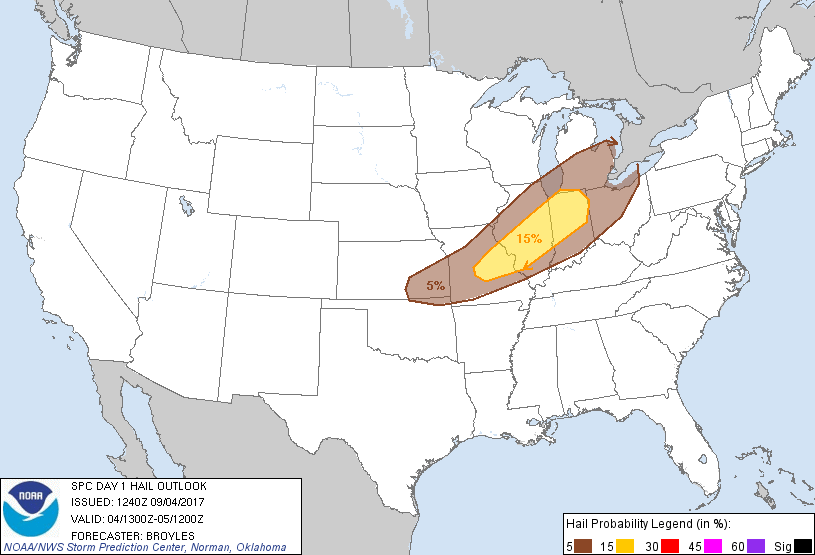
large hail may also develop with the more discrete rotating storms
that develop during the late afternoon, when instability is forecast
to be maximized. A marginal threat for hail and strong wind gusts
will be possible across southwestern Missouri and southeast Kansas
late this afternoon into this early evening.
...Arizona...
An area of high pressure will be in place today from the Four
Corners region northwestward into the Intermountain West.
Thunderstorms are forecast to initiate on the southern periphery of
the high in southern Arizona as instability develops this afternoon.
Forecast soundings at Phoenix for 00Z/Tuesday show instability
mainly in the mid-levels with super-adiabatic lapse rates from the
surface to 700 mb. This may be enough for a few strong wind gusts
especially if a cluster of multicells can get going just after peak
heating.
..Broyles/Guyer.. 09/04/2017
CLICK TO GET WUUS01 PTSDY1 PRODUCT
NOTE: THE NEXT DAY 1 OUTLOOK IS SCHEDULED BY 1630Z