Fargo, ND...Grand Forks, ND...Moorhead, MN...Brookings, SD...Fergus Falls, MN...
2 %
34,426
630,755
Sioux Falls, SD...Willmar, MN...Mitchell, SD...Bemidji, MN...Brandon, SD...
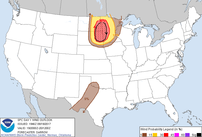
Probabilistic Damaging Wind Graphic
Probability of damaging thunderstorm winds or wind gusts of 50 knots or higher within 25 miles of a point. Hatched Area: 10% of greater probability of wind gusts 65 knots or greater within 25 miles of a point.
Sioux Falls, SD...St. Cloud, MN...Willmar, MN...Mitchell, SD...Brainerd, MN...
5 %
134,701
5,787,872
Minneapolis, MN...St. Paul, MN...Abilene, TX...Wichita Falls, TX...Midland, TX...
SPC AC 191946
Day 1 Convective Outlook
NWS Storm Prediction Center Norman OK
0246 PM CDT Tue Sep 19 2017
Valid 192000Z - 201200Z
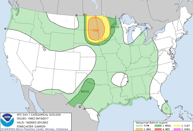
...THERE IS AN ENHANCED RISK OF SEVERE THUNDERSTORMS ACROSS THE
EASTERN DAKOTAS AND WESTERN MN...
...THERE IS A SLIGHT RISK OF SEVERE THUNDERSTORMS FROM SOUTHEAST SD
INTO NORTH-CENTRAL MN...
...THERE IS A MARGINAL RISK OF SEVERE THUNDERSTORMS FROM EXTREME
NORTHEAST NE TO THE ARROWHEAD OF MN...
...THERE IS A MARGINAL RISK OF SEVERE THUNDERSTORMS ACROSS PORTIONS
OF THE SOUTHERN PLAINS...
...SUMMARY...
Severe storms with a threat for a few tornadoes, numerous large hail
and damaging wind events, a few of which should be significant, are
expected across parts of the eastern Dakotas into western Minnesota
from about 4 pm to 4 am CDT.
...Discussion...
No significant changes to 1630z outlook are warranted.
Pre-frontal warm advection convection is spreading across portions
of ND well ahead of primary short-wave trough. While this activity
may generate locally severe hail or wind gusts it appears stronger
convection will evolve in its wake later this afternoon. Earlier
thoughts regarding the evolution of severe thunderstorms remain.
..Darrow.. 09/19/2017
.PREV DISCUSSION... /ISSUED 1123 AM CDT Tue Sep 19 2017/
...Synopsis...
Satellite and RAP analysis data indicate several impulses moving
through a broad synoptic upper trough that is situated over the
northwestern states. A lead shortwave trough is currently moving
northeast through eastern MT into western ND, and an upstream
impulse will affect this region this afternoon.
...Central and eastern Dakotas into Minnesota...
Late this morning a cold front extends from a weak surface low
through the western Dakotas into eastern WY preceded by a
pre-frontal trough. A warm front stretches from central MN through
southern and western ND. Low to mid 60s F boundary layer dewpoints
will advect through pre-frontal warm sector beneath plume of steep
lapse rates, sampled by 12Z RAOBS, contributing to a corridor of
moderate instability with 1500-2500 J/kg MLCAPE. However, strong
convective inhibition associated with the elevated mixed layer and
widespread multi-layer clouds should delay more robust thunderstorm
development until late afternoon. Mid-level convection embedded
within multi-layer cloud plume will continue spreading through the
warm sector with limited solar insolation. This and strong
convective inhibition suggest most of the robust thunderstorm
development will probably remain confined to the zone of stronger
forcing along eastward-advancing cold front during the late
afternoon. The low-level jet will strengthen within the exit region
of an approaching mid-upper jet resulting in strong (45-55 kt)
effective bulk shear supportive of organized severe storms. Mixed
modes with both supercells and linear bowing segments are expected
early in the storms evolution, with a gradual trend toward upscale
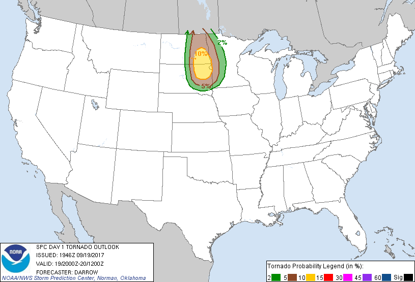
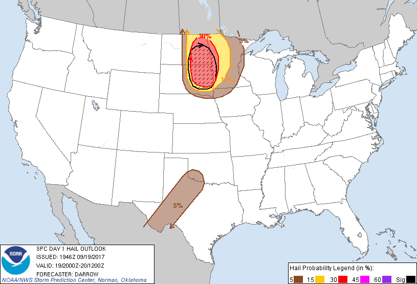
linear growth during the evening. Tornadoes, very large hail and
damaging wind are all possible. Overall tornado threat will depend
to some degree on mode evolution and appears to be greatest in
corridor from northeast South Dakota into southeast North Dakota.
Later this evening into overnight storms will continue into the
upper Mississippi Valley with damaging wind becoming the primary
threat.
...West TX to southwest OK...
The dryline will be the focus for isolated to scattered storm
development late afternoon to early evening. Steep 700-500 mb lapse
rates of 7-8 C/km will support moderate buoyancy with MLCAPE
reaching 1500-2500 J/kg. While mid-level winds will be modest,
veering of the wind profile with height should yield 25-30 kt
effective shear, supporting a few transient supercell and multicell
clusters. Isolated occurrences of large hail and damaging winds are
possible before storms wane after sunset.
CLICK TO GET WUUS01 PTSDY1 PRODUCT
NOTE: THE NEXT DAY 1 OUTLOOK IS SCHEDULED BY 0100Z