Madison, WI...Dubuque, IA...Stevens Point, WI...Fitchburg, WI...Wisconsin Rapids, WI...
MARGINAL
88,159
6,045,485
Kansas City, MO...Overland Park, KS...Rockford, IL...Kansas City, KS...Cedar Rapids, IA...
Probabilistic Tornado Graphic
Probability of a tornado within 25 miles of a point. Hatched Area: 10% or greater probability of EF2 - EF5 tornadoes within 25 miles of a point.
Day 1 Tornado Risk
Area (sq. mi.)
Area Pop.
Some Larger Population Centers in Risk Area
No Risk Areas Forecast
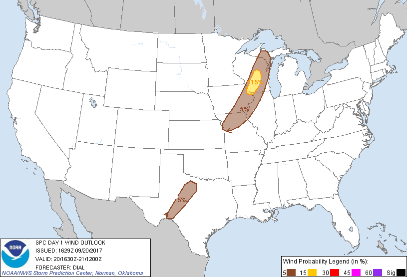
Probabilistic Damaging Wind Graphic
Probability of damaging thunderstorm winds or wind gusts of 50 knots or higher within 25 miles of a point. Hatched Area: 10% of greater probability of wind gusts 65 knots or greater within 25 miles of a point.
Day 1 Wind Risk
Area (sq. mi.)
Area Pop.
Some Larger Population Centers in Risk Area
15 %
11,371
986,292
Madison, WI...Dubuque, IA...Stevens Point, WI...Fitchburg, WI...Wisconsin Rapids, WI...
5 %
88,224
6,009,246
Kansas City, MO...Overland Park, KS...Rockford, IL...Kansas City, KS...Cedar Rapids, IA...
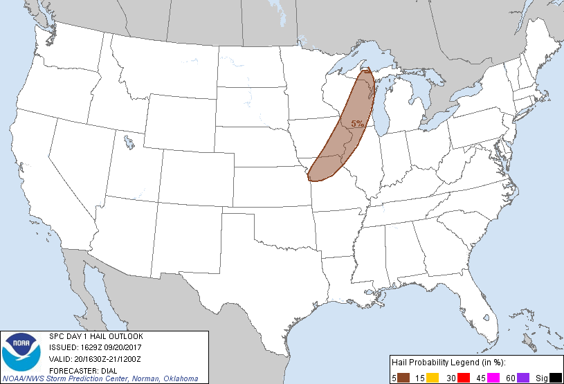
Probabilistic Large Hail Graphic
Probability of hail 1" or larger within 25 miles of a point. Hatched Area: 10% or greater probability of hail 2" or larger within 25 miles of a point.
Day 1 Hail Risk
Area (sq. mi.)
Area Pop.
Some Larger Population Centers in Risk Area
5 %
77,314
6,638,603
Kansas City, MO...Madison, WI...Overland Park, KS...Rockford, IL...Kansas City, KS...
SPC AC 201629
Day 1 Convective Outlook
NWS Storm Prediction Center Norman OK
1129 AM CDT Wed Sep 20 2017
Valid 201630Z - 211200Z
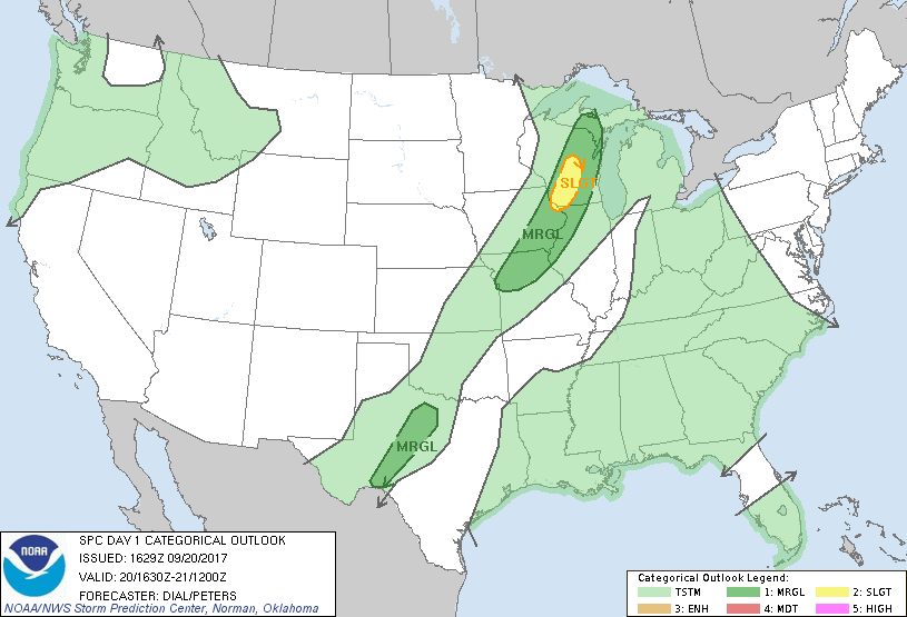
...THERE IS A SLIGHT RISK OF SEVERE THUNDERSTORMS FROM SOUTHWEST
THROUGH CENTRAL WISCONSIN...
...THERE IS A MARGINAL RISK OF SEVERE THUNDERSTORMS FROM THE MIDDLE
MISSISSIPPI VALLEY INTO THE UPPER GREAT LAKES...
...THERE IS A MARGINAL RISK OF SEVERE THUNDERSTORMS FROM SOUTHWEST
THROUGH NORTHWEST TEXAS...
...SUMMARY...
A few strong to severe storms with locally damaging wind and hail
remain possible from the Upper Peninsula of Michigan to northern
Missouri between about 4 to 11 pm CDT. A few strong storms are also
possible from southwest through north central Texas.
...Wisconsin through northern Missouri...
Boundary layer dewpoints in the mid to upper 60s F are advecting
northward through the pre-frontal warm sector, and this will result
in moderate to strong instability with 1500-2500 J/kg MLCAPE this
afternoon. However, mid-level lapse rates will remain modest due to
relatively warm temperatures aloft with -6 to -7C at 500 mb. The
stronger winds aloft will remain in post frontal region but a belt
of moderate flow with 40-50 kt in the 700-400 mb layer will exist in
the frontal zone. Height will rise slightly during the day in wake
of shortwave trough currently lifting into southern Manitoba.
Destabilization of the boundary layer and low-level convergence
should be sufficient to initiate storms along the cold front. Have
introduced a 15% categorical risk area over WI where the best
combination of stronger winds aloft and instability exists.
...Southwest through northwest Texas...
Subsidence aloft associated with low-amplitude shortwave ridging
remains a limiting factor for the development of storms today.
However, strong diabatic heating and mixing in the vicinity of
dryline should result in at least isolated storms from southwest
through northwest TX this afternoon. Temperatures aloft are warm due
to mid-upper subsidence, and this will mitigate mid-level lapse
rates and overall updraft strength despite 2000-3000 J/kg MLCAPE.
Nevertheless, some storms could pose a risk for a few instances of
downburst winds from late afternoon into early evening.
..Dial/Peters.. 09/20/2017
CLICK TO GET WUUS01 PTSDY1 PRODUCT
NOTE: THE NEXT DAY 1 OUTLOOK IS SCHEDULED BY 2000Z