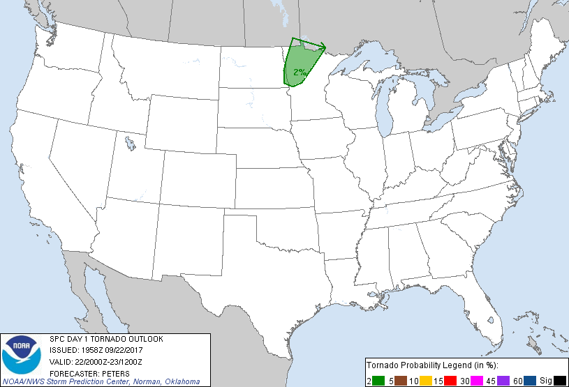
Sioux Falls, SD...Fargo, ND...St. Cloud, MN...Roswell, NM...Clovis, NM...
Probabilistic Tornado Graphic
Probability of a tornado within 25 miles of a point. Hatched Area: 10% or greater probability of EF2 - EF5 tornadoes within 25 miles of a point.
Day 1 Tornado Risk
Area (sq. mi.)
Area Pop.
Some Larger Population Centers in Risk Area
2 %
25,814
489,011
Fargo, ND...Moorhead, MN...West Fargo, ND...West Fargo, MN...Fergus Falls, MN...
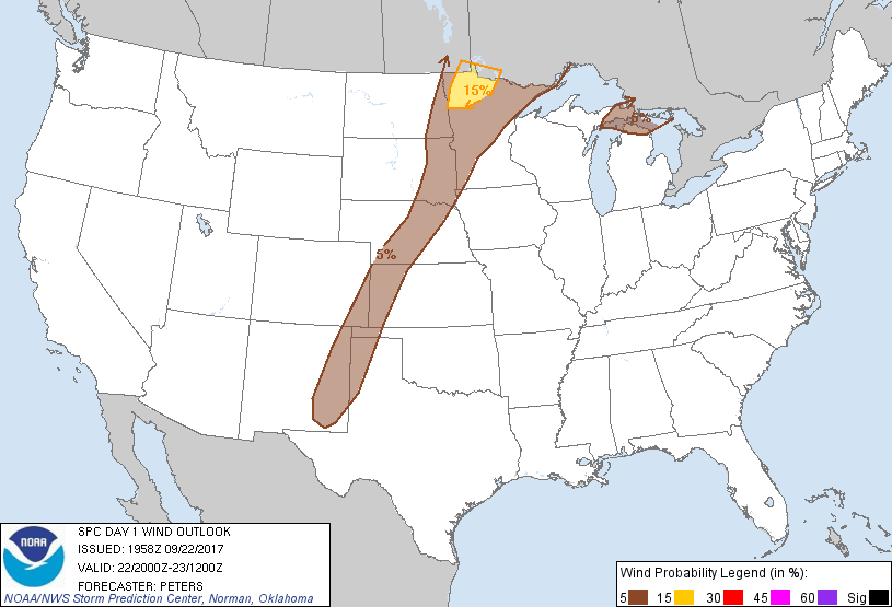
Probabilistic Damaging Wind Graphic
Probability of damaging thunderstorm winds or wind gusts of 50 knots or higher within 25 miles of a point. Hatched Area: 10% of greater probability of wind gusts 65 knots or greater within 25 miles of a point.
Day 1 Wind Risk
Area (sq. mi.)
Area Pop.
Some Larger Population Centers in Risk Area
15 %
13,653
104,306
No Major Population Center in Risk Area
5 %
184,259
2,632,646
Sioux Falls, SD...Fargo, ND...St. Cloud, MN...Grand Forks, ND...Roswell, NM...
Probabilistic Large Hail Graphic
Probability of hail 1" or larger within 25 miles of a point. Hatched Area: 10% or greater probability of hail 2" or larger within 25 miles of a point.
Day 1 Hail Risk
Area (sq. mi.)
Area Pop.
Some Larger Population Centers in Risk Area
15 %
16,785
189,420
Grand Forks, ND...
5 %
211,937
2,368,245
Sioux Falls, SD...Fargo, ND...St. Cloud, MN...Roswell, NM...Clovis, NM...
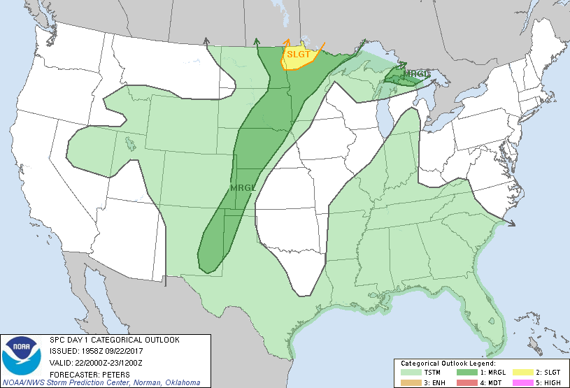
   SPC AC 221958

   Day 1 Convective Outlook
   NWS Storm Prediction Center Norman OK
   0258 PM CDT Fri Sep 22 2017

   Valid 222000Z - 231200Z

   ...THERE IS A SLIGHT RISK OF SEVERE THUNDERSTORMS OVER PARTS OF
   NORTHWEST MINNESOTA AND NORTHEAST NORTH DAKOTA`...

   ...THERE IS A MARGINAL RISK OF SEVERE THUNDERSTORMS SURROUNDING THE
   SLIGHT RISK ACROSS THE UPPER MIDWEST TO THE SOUTHERN HIGH PLAINS...

   ...THERE IS A MARGINAL RISK OF SEVERE THUNDERSTORMS ACROSS EASTERN
   UPPER MI AND A SMALL PART OF NORTHERN LOWER MI...

   ...SUMMARY...
   Isolated severe hail and wind storms are possible from the Upper
   Midwest to the southern High Plains, mainly during the late
   afternoon and evening.  There remains some severe threat this
   afternoon across a small portion of the Upper Great Lakes.  A
   separate severe threat will focus over northwest Minnesota this
   afternoon and evening.

   ...Upper MI and northern Lower MI...
   Mid afternoon mosaic radar imagery showed a band of storms, located
   along the leading edge of an MCS, advancing to the east at 35-40 kt
   into the eastern portion of Upper MI.  Although the downstream
   environment is moderately unstable, including across northern Lower
   MI, objective analyses indicated surface-based inhibition was
   sufficiently strong to potentially limit stronger wind gusts from
   reaching the surface.  High-level clouds spreading east ahead of the
   storms should result in weaker diabatic heating and further preclude
   the reduction of inhibition for surface-based storms.  This data
   suggests a Marginal severe risk is warranted across portions of
   eastern Upper MI and also into northern Lower MI in vicinity of
   stronger instability that could allow a locally strong wind gust,
   but aforementioned reasoning suggests this threat is quite low.

   The severe-weather threat and much of the potential for
   thunderstorms through the remainder of the forecast period across
   western Upper MI and northwest WI has diminished, as the environment
   has generally stabilized in the wake of the eastward-moving MCS.

   ...ND/MN and elsewhere...
   No changes are needed with the rest of the forecast severe risk
   areas.

   ..Peters.. 09/22/2017

   .PREV DISCUSSION... /ISSUED 1116 AM CDT Fri Sep 22 2017/

   ...WI/MI today...
   An ongoing cluster of strong/severe storms has been affecting
   northern WI for several hours.  This cluster is in an environment
   where continued weak low level warm/moist advection and daytime
   heating will help destabilize the boundary layer.  Given the
   persistent nature of the storms, and the slowly increasing mesoscale
   organization of the activity, have added a SLGT risk for wind damage
   across parts of the MI Upper Peninsula.

   ...ND/MN...
   The overall forecast for this region remains unchanged.  A very
   moist/unstable air mass will develop this afternoon in the warm
   sector of a low over northwest MN and eastern ND.  Vertical shear
   profiles will also be quite strong across this region with forecast
   soundings suggesting a conditional risk of supercells and tornadoes
   in warm sector.  However, virtually no 12z CAM guidance shows robust
   convective initiation in the warm sector.  Instead, all storms form
   along and northwest of the warm front, affecting northwest MN and
   northeast ND this afternoon and evening.  Supercell storm structures
   are still expected in the elevated-convective regime, with stable
   near-surface lapse-rates likely limiting the tornado and wind damage
   potential.  Large hail is expected to be the main threat.

   CLICK TO GET WUUS01 PTSDY1 PRODUCT

   NOTE: THE NEXT DAY 1 OUTLOOK IS SCHEDULED BY 0100Z