SPC AC 221250
Day 1 Convective Outlook
NWS Storm Prediction Center Norman OK
0750 AM CDT Sun Oct 22 2017
Valid 221300Z - 231200Z
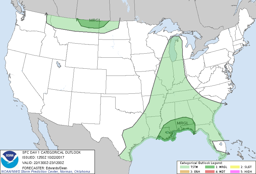
...THERE IS A MARGINAL RISK OF SEVERE THUNDERSTORMS FROM
SOUTHEASTERN LOUISIANA TO PARTS OF THE FLORIDA PANHANDLE...
...THERE IS A MARGINAL RISK OF SEVERE THUNDERSTORMS OVER PARTS OF
THE NORTHERN HIGH PLAINS...
...SUMMARY...
A few severe storms will be possible this afternoon through tonight
near the central Gulf Coast.
...Synopsis...
The main upper-air feature for this forecast will be a
full-latitude, synoptic-scale trough -- currently arching from
southern MB across western MN, eastern KS, central OK, and southwest
TX. Approximately the northern half of this trough will break
northeastward across the upper Great Lakes and ON through the
period, with a cyclone forming on its northern extremity over
northern Hudson Bay. Meanwhile, the southern portion will shift
eastward from the southern Plains across the lower/mid Mississippi
Valley. An embedded/500-mb low should develop this evening over the
west-central Ozarks and move generally eastward near the MO/AR
border toward the Mississippi River. By the end of the period, the
trailing shortwave trough should become slightly negatively tilted,
extending south-southeastward from the low across MS to near BIX and
over the adjoining northern Gulf.
Northern-stream shortwave perturbations -- now evident in
moisture-channel imagery near the coastal Pacific Northwest and
coastal BC -- will cross the northern Rockies today. These features
phase into a strengthening, high-amplitude shortwave trough over MB,
the Dakotas, and NE by 12Z, contributing to some acceleration of the
southern trough/low near the end of the period and into day 2.
At the surface, the 11Z analysis showed a cold front from western
Upper MI across western IL, then southwestward in more diffuse form,
temporarily hung up in one convectively related wake low over
southwestern/south-central MO and another near DAL. The front then
became better-defined again southwestward across the southern Hill
Country to near DRT. A warm/marine frontal zone was evident from
southeastern AR across southwestern and coastal MS,
east-southeastward over shelf waters to near AAF, then in diffuse
form over the north-central FL Peninsula. The warm front should
move slowly east-northeastward across the north-central Gulf coastal
plain through the period. By 00Z, the cold front should reach
western portions of lower MI, IN, KY, and MS, southwestward over the
northwestern Gulf. By 12Z, the cold front should become more
meridional from eastern lower MI through an area of low pressure
over eastern portions of KY/TN, southward across the western FL
Panhandle.
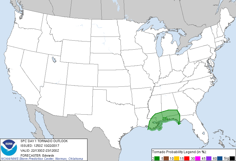
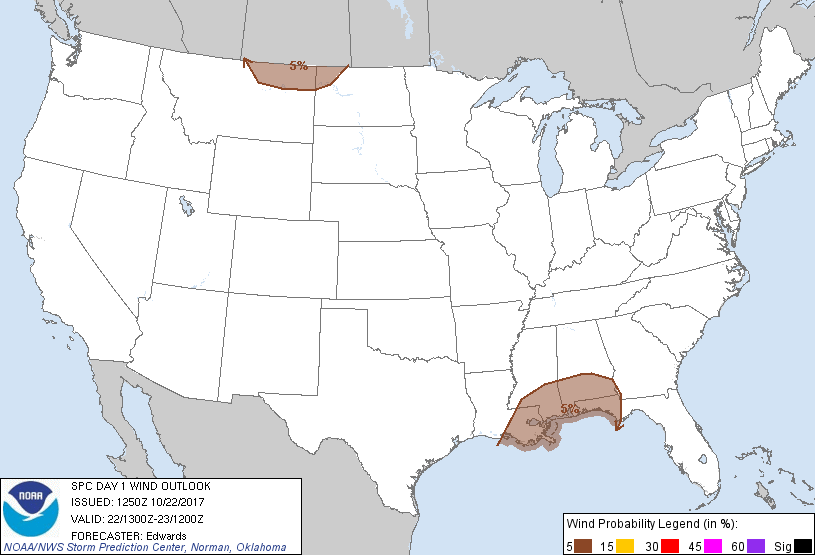
...Central Gulf Coast...
An extensive area of scattered convection is ongoing across portions
of southeastern LA and southern MS, over and southwest of the
effective warm/marine front. While deep shear is not strong over
this region, expect backed flow and well-curved hodographs near the
warm front, along with rich low-level moisture and related low LCL.
This will foster a conditional risk for a brief/small tornado or two
and isolated damaging gusts from the most heavily water-loaded
downdrafts, until the main/pre-cold-frontal convective band
overtakes it from northwest-southeast late morning through early
afternoon.
Areas of diurnal destabilization are likely ahead of that convection
today, augmented by low-level theta-e advection; however, the amount
and pace of that destabilization is in question given the cloud
cover associated with the ongoing convection. Regardless, surface-
based effective-inflow parcels should be available across most or
all of the risk area as the marine air shifts slowly inland,
displacing a recycled continental/polar air mass from the frontal
passage a few days ago. Meanwhile, with the approach of the basal
trough aloft, overlying mid/upper winds should contribute to an
increase in deep shear over the warm sector and the potential for
sporadic organized convection, with damaging gusts the main concern;
a tornado cannot be ruled out.
Overnight, as the mid/upper trough and associated vorticity banner
become more negatively tilted, the resulting adjustment of kinematic
geometry will result in an eastward acceleration of the southern
part of the corridor of most favorable lift near the front. That,
in turn, should reorient the main convective plume more north-south
with some acceleration possible the last 3-6 hours of the period.
Spreading of large-scale ascent (from both DCVA and warm advection)
over more of the warm sector also is possible, supporting
development of surface-based or nearly surface-based convection over
the Gulf, moving inland with some merger into the main line
possible. All of these factors support an eastward expansion of the
existing outlook area at least to near the Apalachicola/
Chattahoochee River system for tonight. Some subset of the "MRGL"
area may need an upgrade in succeeding outlooks, once uncertainties
are better-resolved regarding the impact of the large area of
ongoing convection on favorable destabilization to its east.
...Northern High Plains...
As the northwestern shortwave trough consolidates/intensifies and
approaches, both large-scale lift and deep-layer flow will intensify
markedly. Accordingly, high-wind warnings are in effect for much of
this region. Isolated thunderstorms may supplement the already
strong-severe gradient flow at the surface late this afternoon,
resulting in damaging/severe gusts in convective downdrafts.
Forecast soundings, modified for high temps in the lower 60s F,
yield steep low/middle-level lapse rates and well-mixed boundary
layers conducive to convective downward transfer of momentum through
the short vertical distance from a field of 50-60-kt flow in the
850-700-mb layer. Essentially uninhibited MLCAPE of 100-200 J/kg is
possible with low CAPE density, but also, buoyancy extending into
the icing layer suitable for at least isolated lightning production.
The threat should diminish markedly after dark with surface
diabatic stabilization and resultant loss of both CAPE and DCAPE.
..Edwards/Dean.. 10/22/2017
CLICK TO GET WUUS01 PTSDY1 PRODUCT
NOTE: THE NEXT DAY 1 OUTLOOK IS SCHEDULED BY 1630Z
|