Tallahassee, FL...Dothan, AL...Pensacola, FL...Panama City, FL...Ferry Pass, FL...
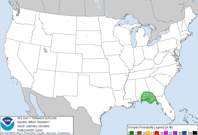
Probabilistic Tornado Graphic
Probability of a tornado within 25 miles of a point. Hatched Area: 10% or greater probability of EF2 - EF5 tornadoes within 25 miles of a point.
Day 1 Tornado Risk
Area (sq. mi.)
Area Pop.
Some Larger Population Centers in Risk Area
2 %
24,398
1,644,794
Tallahassee, FL...Dothan, AL...Panama City, FL...Wright, FL...Enterprise, AL...
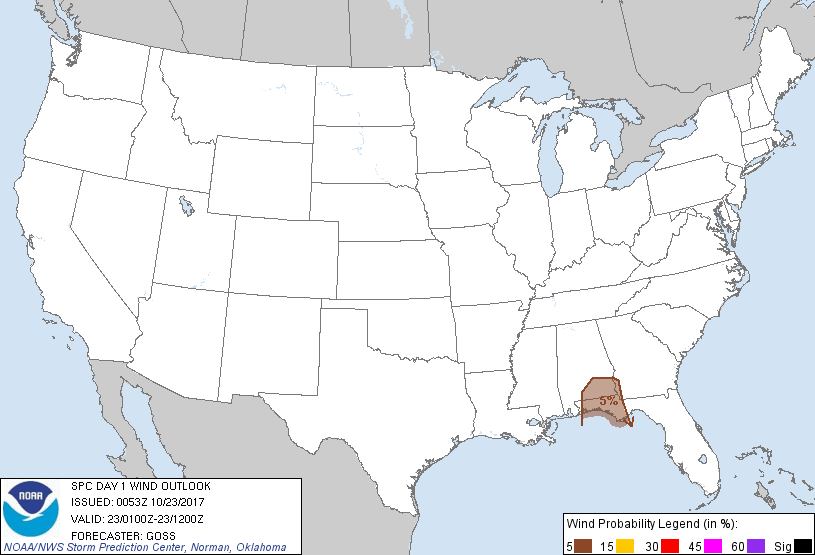
Probabilistic Damaging Wind Graphic
Probability of damaging thunderstorm winds or wind gusts of 50 knots or higher within 25 miles of a point. Hatched Area: 10% of greater probability of wind gusts 65 knots or greater within 25 miles of a point.
Day 1 Wind Risk
Area (sq. mi.)
Area Pop.
Some Larger Population Centers in Risk Area
5 %
18,548
1,183,012
Dothan, AL...Panama City, FL...Wright, FL...Enterprise, AL...Fort Walton Beach, FL...
Probabilistic Large Hail Graphic
Probability of hail 1" or larger within 25 miles of a point. Hatched Area: 10% or greater probability of hail 2" or larger within 25 miles of a point.
Day 1 Hail Risk
Area (sq. mi.)
Area Pop.
Some Larger Population Centers in Risk Area
No Risk Areas Forecast
SPC AC 230053
Day 1 Convective Outlook
NWS Storm Prediction Center Norman OK
0753 PM CDT Sun Oct 22 2017
Valid 230100Z - 231200Z
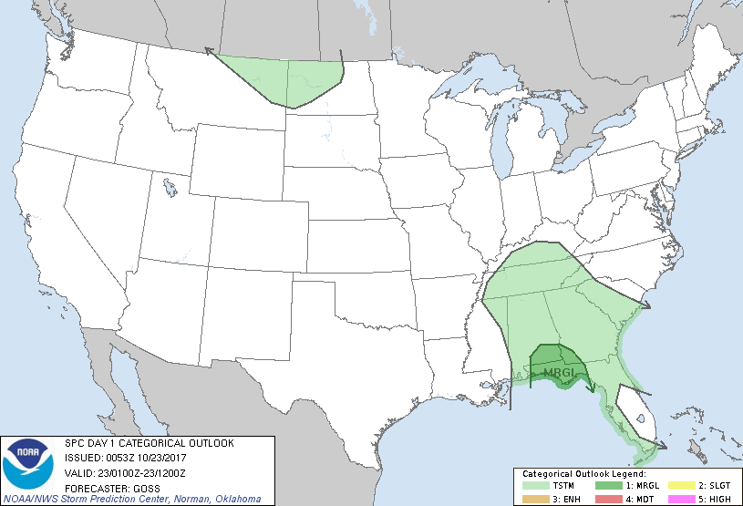
...THERE IS A MARGINAL RISK OF SEVERE THUNDERSTORMS ACROSS PORTIONS
OF THE CENTRAL AND EASTERN GULF COAST REGION...
...SUMMARY...
Isolated damaging gusts and a brief tornado or two remain possible
tonight across parts of southern Alabama and the Florida Panhandle,
and possibly into southwest Georgia.
...Discussion...
A large area of pre-frontal convection continues across parts of the
southeast U.S. this evening. Prior rotating storms near the
Alabama/Florida Panhandle coast have weakened, as the loss of
diurnal heating and increasingly widespread convection have reduced
the already modest available instability.
With that said, ample shear -- including some turning in the lowest
couple of KM with height -- will persist across the area into the
overnight hours. As such, will maintain a MRGL risk area for
locally gusty winds or even a brief tornado or two, and will expand
this risk area a bit eastward -- into southwest GA and the remainder
of the FL panhandle -- per latest CAM runs suggesting an increase in
warm-advection-driven storms over the next few hours across this
area.
..Goss.. 10/23/2017
CLICK TO GET WUUS01 PTSDY1 PRODUCT
NOTE: THE NEXT DAY 1 OUTLOOK IS SCHEDULED BY 0600Z