Memphis, TN...Little Rock, AR...Cedar Rapids, IA...Peoria, IL...Davenport, IA...
Probabilistic Tornado Graphic
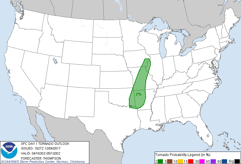
Probability of a tornado within 25 miles of a point. Hatched Area: 10% or greater probability of EF2 - EF5 tornadoes within 25 miles of a point.
Day 1 Tornado Risk
Area (sq. mi.)
Area Pop.
Some Larger Population Centers in Risk Area
2 %
82,510
4,944,032
Little Rock, AR...Springfield, MO...Davenport, IA...Columbia, MO...Fort Smith, AR...
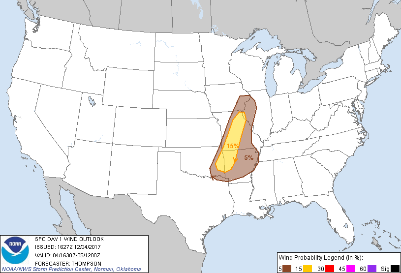
Probabilistic Damaging Wind Graphic
Probability of damaging thunderstorm winds or wind gusts of 50 knots or higher within 25 miles of a point. Hatched Area: 10% of greater probability of wind gusts 65 knots or greater within 25 miles of a point.
SPC AC 041627
Day 1 Convective Outlook
NWS Storm Prediction Center Norman OK
1027 AM CST Mon Dec 04 2017
Valid 041630Z - 051200Z
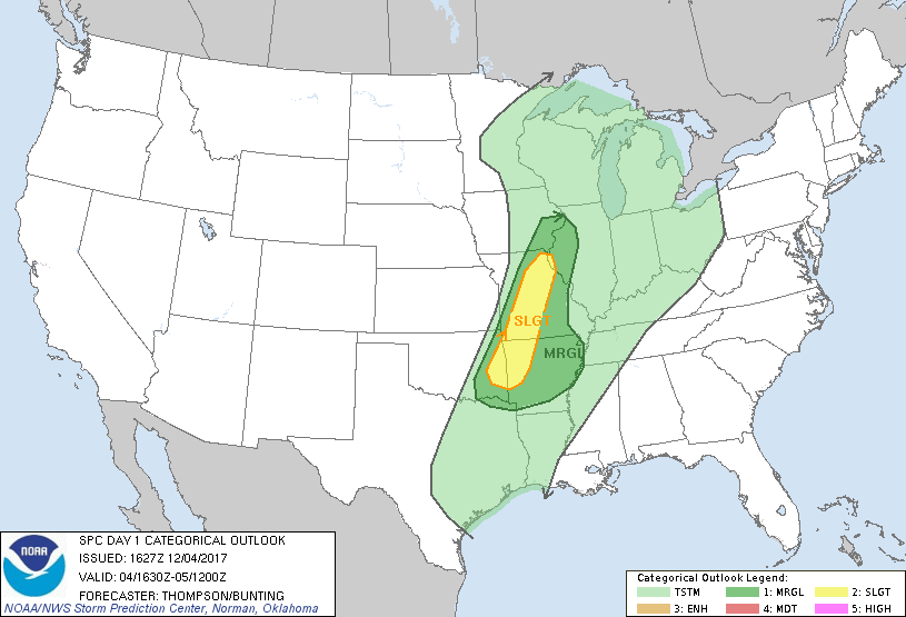
...THERE IS A SLIGHT RISK OF SEVERE THUNDERSTORMS LATE THIS
AFTERNOON/EVENING FROM EASTERN OK AND NORTHWESTERN AR TO
NORTHEASTERN MO...
...THERE IS A MARGINAL RISK OF SEVERE THUNDERSTORMS THIS AFTERNOON
THROUGH TONIGHT FROM SOUTHEASTERN IA/NORTHWESTERN IL TO EXTREME
NORTHEASTERN TX AND AR...
...SUMMARY...
Isolated strong to severe thunderstorms are expected across eastern
Oklahoma and the Ark-La-Tex region into Missouri and southeast
Iowa/northwest Illinois late this afternoon into tonight.
...Synopsis...
A surface cyclone in southwest MN this morning will move toward Lake
Superior by tonight, with rapid deepening expected in response to
strong deep-layer forcing for ascent within the left exit region of
a 130 kt upper jet streak. An associated surface cold front will
surge southeastward in the wake of the cyclone and cross the mid MS
Valley and southern Plains by the end of this forecast period. In
advance of the cold front, a narrow moist sector with boundary-layer
dewpoints in the mid 50s into IA and mid-upper 60s in TX, will
continue to spread northeastward through the day. Though surface
heating will be tempered by widespread clouds, the low-level
moisture and remnant steep midlevel lapse rates will support at
least weak surface-based buoyancy as far northeast as parts of
IA/IL.
...Mid MS Valley to the Ozarks through tonight...
Thunderstorm development is expected in a band along the cold front
from mid-late afternoon (21-23z). It appears there will be a 2-4
hour window of opportunity for damaging winds (and perhaps an
isolated tornado) this evening as far northeast as southeast IA and
northwest IL, given buoyancy rooted at the surface and 50-60 kt flow
just above the surface. Strong deep-layer shear may support
embedded supercells within the line for a few hours this evening.
The frontal convection will maintain intensity longer from eastern
OK into AR, where mid 60s dewpoints will drive at least weak
buoyancy into tonight. However, the convection will become more
anafrontal with time and low-level flow will veer/weaken, which will
limit the southwestward extent of any severe-storm threat.
..Thompson/Bunting.. 12/04/2017
CLICK TO GET WUUS01 PTSDY1 PRODUCT
NOTE: THE NEXT DAY 1 OUTLOOK IS SCHEDULED BY 2000Z