San Antonio, TX...Austin, TX...New Orleans, LA...Baton Rouge, LA...Shreveport, LA...
SPC AC 131736
Day 2 Convective Outlook
NWS Storm Prediction Center Norman OK
1136 AM CST Mon Feb 13 2017
Valid 141200Z - 151200Z
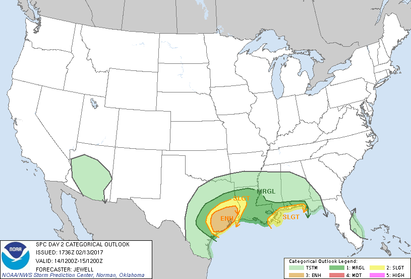
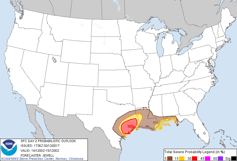
...THERE IS AN ENHANCED RISK OF SEVERE THUNDERSTORMS ACROSS MUCH OF
SOUTHEASTERN TX...
...THERE IS A SLIGHT RISK OF SEVERE THUNDERSTORMS FROM EASTERN TX
INTO WESTERN LA...
...THERE IS A SLIGHT RISK OF SEVERE THUNDERSTORMS FROM FAR SOUTHEAST
LA ACROSS COASTAL MS/AL AND THE FL PANHANDLE...
...THERE IS A MARGINAL RISK OF SEVERE THUNDERSTORMS FROM CENTRAL TX
ACROSS THE CNTRL GULF COAST...
...SUMMARY...
Strong to severe thunderstorms are expected to develop from central
into eastern Texas and perhaps western Louisiana throughout the day
on Tuesday, with a few tornadoes and damaging winds expected. A more
conditional threat of isolated severe storms will also exist Tuesday
night into Wednesday morning from the mouth of the Mississippi river
toward the coastal Florida panhandle.
...Synopsis...
A shortwave trough will move eastward across TX and toward the lower
MS valley on Tuesday, losing amplitude overnight and becoming more
zonal. At the surface, low pressure will deepen across east TX ahead
of a cold front, with warm front lifting northward ahead of the low
track. Substantial moisture will be available to support severe
storms as dewpoints rise into the mid to upper 60s beneath cooling
temperatures aloft. Strengthening shear profiles with 60 kt
southwesterly midlevel flow atop a 40-50 kt southerly low level jet
will support the possibility of damaging storms mainly during the
day, including the threat for tornadoes.
...Central and eastern Texas toward the Sabine river...
Substantial low-level moisture is already in place today from the
central TX coast into Deep South Texas, and this air mass will
spread northward on Tuesday ahead of the developing surface low and
cold front. Environmentally, models indicate strong low-level shear
developing with 0-3 km SRH in the 300-400 m2/s2 range, which is very
supportive of supercells given the moist air mass and adequate
instability. Hodographs look most favorable over east central into
southeast Texas between 15Z-21Z, before the low-level jet veers as
the shortwave passes to the north.
As for storm evolution, scattered storms are forecast to be ongoing
along the cold front over central TX at the beginning of the period.
Some of these storms may contain a hail or wind risk, but the threat
should increase further by late morning mainly east of the I-35
corridor. By 15Z-18Z, a marked uptick in storm strength is expected,
with storms both just ahead of and along the cold front. In both
cases, supercells are expected initially, with a threat of
tornadoes. The threat might transition to damaging winds during the
late afternoon and with northward extent, as the cold front and
outflows result in merged storms and instability wanes.
Any discrete supercells will have a threat of tornadoes in this
environment. Mitigating factors to tornado longevity may be some
weakness in wind fields around 700 mb especially in southern areas,
and potential for numerous storm interactions. However, a strong
tornado or two cannot be ruled out.
...Southeast Louisiana, coastal MS and AL and the far western FL
Panhandle...
Flow aloft will become quite strong Tuesday night into Wednesday
morning as the shortwave trough deamplifies. However, gradual height
falls/cooling aloft will persist, and a warm front will be located
from southeast LA eastward along or just off the coast. Lift via
warm advection is likely to result in a few storms over the northern
Gulf, perhaps affecting the coast. Models insist on far southeastern
LA as the main threat area, but a few also show storms as far east
as the western FL panhandle by 12Z Wednesday. Thus, will maintain a
conditional Slight risk, for these areas for tornado/wind potential.
..Jewell.. 02/13/2017
CLICK TO GET WUUS02 PTSDY2 PRODUCT
NOTE: THE NEXT DAY 2 OUTLOOK IS SCHEDULED BY 0700Z