SPC AC 280700
Day 2 Convective Outlook
NWS Storm Prediction Center Norman OK
0100 AM CST Tue Feb 28 2017
Valid 011200Z - 021200Z
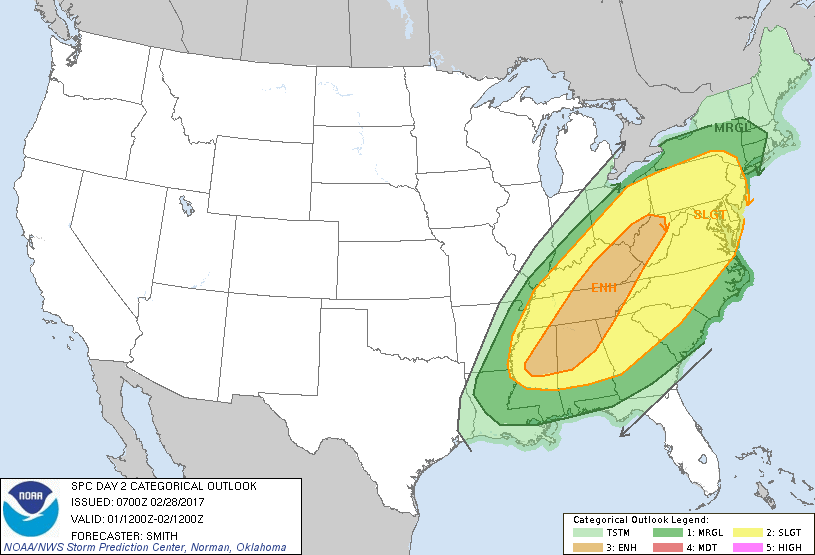
...THERE IS AN ENHANCED RISK OF SEVERE THUNDERSTORMS FROM PARTS OF
MISSISSIPPI AND ALABAMA NORTHEASTWARD INTO EASTERN KENTUCKY AND THE
UPPER OHIO VALLEY...
...THERE IS A SLIGHT RISK OF SEVERE THUNDERSTORMS FROM THE LOWER
MISSISSIPPI VALLEY NORTHEASTWARD INTO THE OHIO VALLEY AND WESTERN
CAROLINAS AND NORTHWARD INTO THE MID-ATLANTIC STATES AND INTO NEW
JERSEY AND PENNSYLVANIA...
...THERE IS A MARGINAL RISK OF SEVERE THUNDERSTORMS SURROUNDING THE
SLIGHT RISK...
...SUMMARY...
Strong to severe thunderstorms will be possible from the lower
Mississippi Valley northeastward across the Tennessee Valley and
southern Appalachians, and northward into parts of the Mid-Atlantic
states and into portions of the Northeast. Damaging winds are
forecast to be the predominant severe hazard.
...Synopsis...
A large-scale mid-level trough axis over the central states will
move eastward into the lower Great Lakes/Mid-Atlantic states. A
100+ kt 500-mb speed max will translate generally eastward from the
OH Valley through New England and the Mid-Atlantic region during the
period. In the low levels, a surface low is forecast to develop
northeastward from near Detroit to northern parts of New England
Wednesday night as a warm front advances northward across much of
the northeastern U.S. A cold front initially over the OH Valley
extending south-southwestward into the lower MS Valley will sweep
eastward across much of the eastern U.S. by early Thursday morning.
...northern parts of AL/MS northeastward into the central
Appalachians and Mid-Atlantic states...
A squall line will likely be ongoing Wednesday morning across the OH
Valley with some possible breaks and lower storm coverage farther
south into the lower MS Valley. A risk for damaging winds will
accompany the convective line as a plume of low-level moisture
--featuring surface dewpoints ranging from around 60 degrees F at
the OH River to the middle 60s in MS/AL-- contributes to 500-1000
J/kg MUCAPE ahead of the cold front. Although some slight timing
differences still exist in the models, favoring a timing solution
similar to the ECMWF/CMC.
A strong deep-layer wind field of southwesterly flow from 50-60 kt
at 850 mb and increasing with height to 70-100 kt in the midlevels,
will aid in the potential risk for widespread wind damage associated
with a squall line and other linearly organized storm clusters.
Some tornado risk may develop as well with mature linear bands
(short-lived QLCS variety) or where greater destabilization occurs.
Uncertainty remains regarding destabilization to the east of the
mountains in the Mid-Atlantic region. Will defer adding higher
severe probabilities for this area for the time being.
The activity will push east of the Appalachians by early evening and
encounter gradually decreasing buoyancy in part due to the loss of
heating and deeper inland mixing from southern GA northeastward
along the Carolina coastal plain. As a result, there will likely be
a corresponding decrease in the potential for damaging winds farther
south in parts of the Southeast.
...northern PA into NY and southern New England...
Strong low-level moisture/warm-air-advection into this area will
lead to weak destabilization ahead of the cold front. Models vary
on the degree of destabilization leading to uncertainty regarding
coverage of strong/severe storms. Very strong low- to
mid-tropospheric flow coupled with several hundred SBCAPE may result
in some of the stronger storms or a convective line to potentially
be capable of a risk for primarily damaging winds.
..Smith.. 02/28/2017
CLICK TO GET WUUS02 PTSDY2 PRODUCT
NOTE: THE NEXT DAY 2 OUTLOOK IS SCHEDULED BY 1730Z