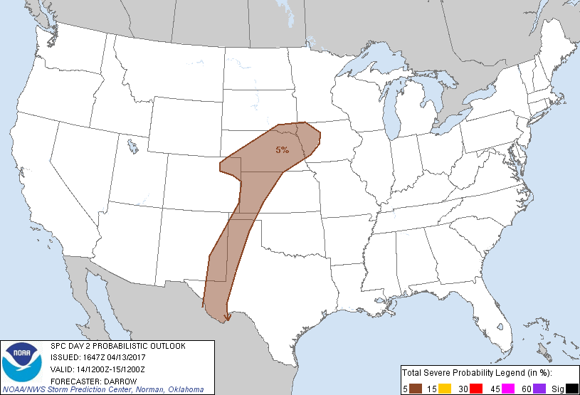
Omaha, NE...Lincoln, NE...Amarillo, TX...Sioux City, IA...Council Bluffs, IA...
Probabilistic Graphic
Probability of severe weather within 25 miles of a point. Hatched Area: 10% or greater probability of significant severe within 25 miles of a point.
Day 2 Prob. Risk
Area (sq. mi.)
Area Pop.
Some Larger Population Centers in Risk Area
5 %
184,725
3,603,564
Omaha, NE...Lincoln, NE...Amarillo, TX...Sioux City, IA...Council Bluffs, IA...
SPC AC 131647
Day 2 Convective Outlook
NWS Storm Prediction Center Norman OK
1147 AM CDT Thu Apr 13 2017
Valid 141200Z - 151200Z
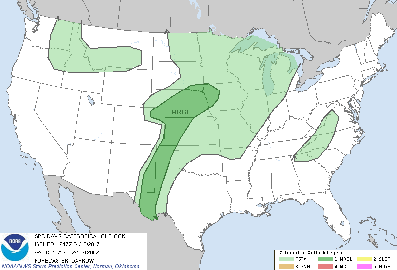
...THERE IS A MARGINAL RISK OF SEVERE THUNDERSTORMS FROM THE HIGH
PLAINS OF WEST TX TO THE MIDDLE MO VALLEY...
...SUMMARY...
Isolated severe thunderstorms, potentially capable of hail and gusty
winds, are possible Friday from the central Great Plains southward
into the southern High Plains and into parts of the middle Missouri
Valley Friday night.
...Central US...
Weak mid-level height falls will glance the central Plains Friday as
primary large-scale forcing for ascent spreads across the northern
Plains and central Provinces of Canada. Broad upper troughing is
expected to influence the Rockies through the period and this will
maintain a lee surface trough/dry line from far West TX into NE.
Lee cyclone will be shunted off the higher terrain across NE late
Friday, as a pronounced surface ridge builds east towards the
northern Plains, forcing a cold front to a position from MN into
northeast CO by 15/12z.
In the absence of meaningful forcing along the dry line,
boundary-layer heating will be the primary mechanism for inducing
isolated thunderstorms across the High Plains. Forecast soundings
suggest convective temperatures will be breached after 22z and there
will likely be adequate low-level convergence along the dry line for
a few storms by late afternoon - a few likely supercellular in
nature. Large hail and gusty winds would be the primary threats
with any dry line storms. This activity should weaken with loss of
daytime heating.
Farther north across the central Plains into the middle MO Valley,
low-level warm advection will be noted through the period from NE
into IA. Models suggest LLJ will strengthen during the latter half
of the period and any heat-induced storms that generate over western
NE should be maintained within the warm advection zone extending
into northwest IA during the overnight hours. Large hail and
locally damaging winds are the primary threats with this activity.
..Darrow.. 04/13/2017
CLICK TO GET WUUS02 PTSDY2 PRODUCT
NOTE: THE NEXT DAY 2 OUTLOOK IS SCHEDULED BY 0600Z