SPC AC 201729
Day 2 Convective Outlook
NWS Storm Prediction Center Norman OK
1229 PM CDT Thu Apr 20 2017
Valid 211200Z - 221200Z
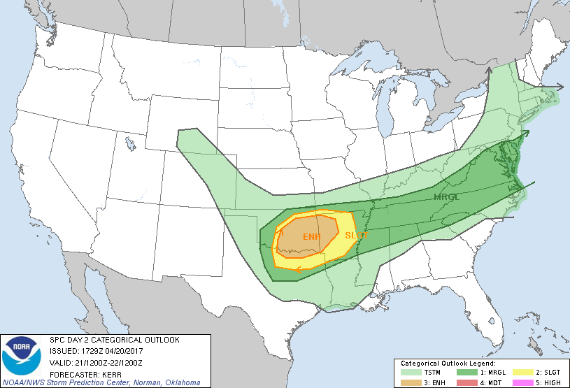
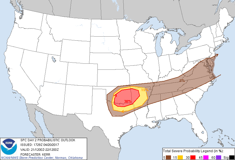
...THERE IS AN ENHANCED RISK OF SEVERE THUNDERSTORMS FRIDAY INTO
FRIDAY NIGHT ACROSS PARTS OF CENTRAL AND EASTERN OKLAHOMA...AND
ADJACENT NORTHEASTERN TEXAS...INTO WESTERN ARKANSAS...
...THERE IS A SLIGHT RISK OF SEVERE THUNDERSTORMS ACROSS SURROUNDING
AREAS OF OKLAHOMA...NORTHEAST TEXAS...NORTHWESTERN
LOUISIANA...ARKANSAS AND SOUTHWESTERN MISSOURI...
...THERE IS A MARGINAL RISK OF SEVERE THUNDERSTORMS ACROSS
SURROUNDING AREAS OF THE SOUTHERN PLAINS...MISSISSIPPI AND TENNESSEE
VALLEYS INTO THE MID ATLANTIC COAST REGION...
...SUMMARY...
One or two clusters of severe storms may evolve Friday through
Friday night across parts of the south central Plains into the Ozark
Plateau. Strong thunderstorms may also impact portions of the
Tennessee Valley into the Mid Atlantic Coast region, with at least
some risk for severe weather.
...Synopsis...
Mid/upper flow appears likely to remain progressive through this
period, with much of the U.S. under the influence of a generally
zonal belt of westerlies emanating from the mid-latitude Pacific.
Within this regime, one significant wave and embedded modest cyclone
are expected to shift east of the lower Great Lakes region through
the St. Lawrence Valley. Upstream troughing, comprised of at least
a couple of significant smaller scale perturbations, appears likely
to redevelop east southeast of the U.S. intermountain region.
Models suggest that the lead impulse within this latter regime will
turn east of the Colorado Rockies early Friday, before continuing
eastward through portions of the middle Mississippi Valley and Ozark
Plateau by 12Z Saturday, as another impulse digs from the northern
intermountain region through Wyoming/Colorado Rockies.
In lower levels, weak secondary surface cyclogenesis may take place
along a southeastward advancing frontal zone, across or east of the
northern Mid Atlantic Coast. Somewhat stronger surface wave
development is possible along the front across the south central
Plains into the Ozark Plateau. Substantive further inland
moistening off the western Gulf of Mexico appears unlikely, but
moisture already present probably will contribute to sufficient
instability to support considerable thunderstorm development along
and ahead of the cold front, from parts of the southern Plains into
the Mid Atlantic Coast region.
...South central Plains into Ozark Plateau...
Forcing associated with lower/mid tropospheric warm advection may be
supporting considerable thunderstorm activity across the region at
the outset of the period. This may be sustained through much of the
day, with strongest activity expected to become focused across parts
of eastern Oklahoma into Arkansas, on the nose of a plume of warmer
and more strongly capping elevated mixed layer air emanating from
the Mexican Plateau region. This regime probably will be conducive
to the risk for severe hail, particularly as a 50-70+ kt cyclonic
500 mb jet noses into/through northern Oklahoma by Friday afternoon.
Exit region forcing associated with this latter feature may remain
mostly displaced to the north of the destabilizing pre-frontal
boundary layer, but in the wake of possible upscale growing early
day convective development, low/mid-level warm advection may support
renewed vigorous convective development across parts of central into
southeastern Oklahoma by late Friday afternoon. This seems most
likely near the southwestern flank of early day convectively
generated outflow, and the cold front/dryline.
Inflow of a moist unstable boundary layer characterized by CAPE at
least on the order of 1000+ J/kg, and perhaps up to 2000 J/kg, may
support at least isolated supercell development initially. This may
be accompanied by a window of opportunity for a tornado or two, in
the presence of sizable clockwise curved low-level hodographs
supported by 30-40 kt southerly 850 mb flow, before forcing
associated with warm advection aids upscale growth into an
organizing convective system. As this occurs, severe weather
potential should transition to a risk for primarily potentially
damaging wind gusts as activity tends to develop southeastward
toward the Red River before weakening Friday night.
...Tennessee Valley into Mid Atlantic Coast region...
Severe weather potential with possible thunderstorm activity
along/ahead of the southward advancing surface front remains
somewhat unclear for Friday/Friday evening. This corridor may
remain to the south of the stronger flow fields associated with the
trough crossing the Great Lakes region into the St. Lawrence Valley.
And lower/mid tropospheric lapse rates are not expected to be
particularly steep. Still, though, models suggest at least pockets
of weak to moderate boundary layer destabilization are possible
across the Tennessee Valley into the lee of the central
Appalachians. It may not be out of the question that the
environment will become conducive to at least widely scattered
thunderstorm development capable of producing marginally severe hail
and/or potentially damaging surface gusts.
..Kerr.. 04/20/2017
CLICK TO GET WUUS02 PTSDY2 PRODUCT
NOTE: THE NEXT DAY 2 OUTLOOK IS SCHEDULED BY 0600Z