San Antonio, TX...Columbus, OH...Memphis, TN...Baltimore, MD...Oklahoma City, OK...
SPC AC 281741
Day 2 Convective Outlook
NWS Storm Prediction Center Norman OK
1241 PM CDT Fri Apr 28 2017
Valid 291200Z - 301200Z
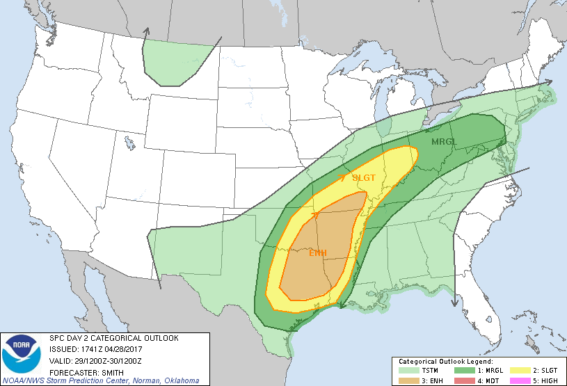
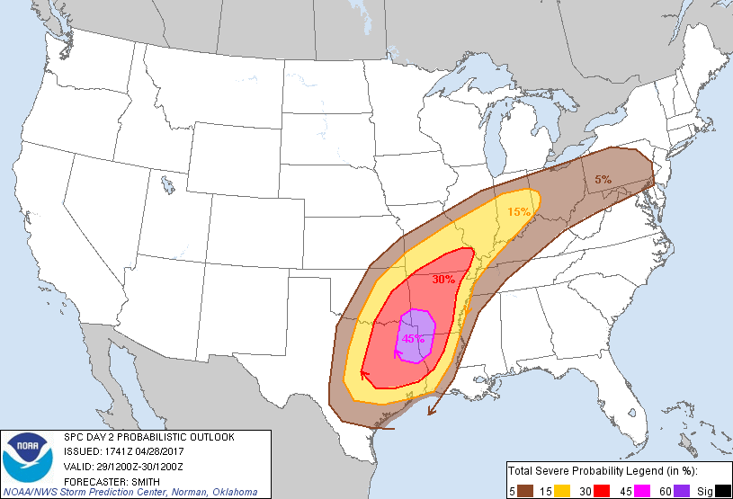
...THERE IS AN ENHANCED RISK OF SEVERE THUNDERSTORMS FROM CENTRAL
TEXAS AND EASTERN OKLAHOMA NORTHEAST INTO THE ARKLATEX AND OZARKS...
...THERE IS A SLIGHT RISK OF SEVERE THUNDERSTORMS FROM CENTRAL TEXAS
NORTHEAST INTO THE MIDDLE MISSISSIPPI AND OHIO VALLEY...
...THERE IS A MARGINAL RISK OF SEVERE THUNDERSTORMS SURROUNDING THE
SLIGHT RISK...
...SUMMARY...
Severe thunderstorms are expected from parts of central Texas
northeastward to portions of the Ohio Valley Saturday into Saturday
night. These storms will be capable of large hail, damaging winds,
and a few tornadoes.
...Synopsis...
Midday Friday water-vapor imagery shows an amplifying mid-level
trough over the western U.S. while a ridge builds downstream over
the Southeast coast. A mid-level low will develop over the Four
Corners and move east into the TX Panhandle/western OK by early
Sunday morning. In the low levels, a surface low over the southern
Plains will slowly move northeast into the Ozarks while a stationary
frontal zone ---location likely modulated by thunderstorm outflow
prior to and during the day 2 period--- is draped east-northeast
from central OK through MO and into the OH Valley. An arctic cold
front will push southward into the Permian Basin during the morning
before it and a Pacific cold front combine and accelerate southeast
across TX and into the lower Sabine Valley by daybreak Sunday
coincident with the upper trough pivoting east.
...TX and OK into the ArkLaTex...
Strong low-level southerly flow will advect a maritime tropical
airmass ---featuring lowest 100-mb mean mixing ratios (at or above
16 g/kg) and translating to 70-74 degree F surface dewpoints--- in
much of the warm sector across the ArkLaTex region and northeastward
into northern portions of the lower MS Valley. Ongoing
thunderstorms are likely across portions of OK near the terminus of
a 60-kt LLJ as the cold front impinges on the warm sector. Isolated
severe hail and severe gusts are possible with this initial
activity. An elevated mixed layer and capping inversion will allow
a very unstable boundary layer (MLCAPE 2500-4000 J/kg) to develop
south of convective outflow and cloud debris across southeast OK/AR
and into eastern and central portions of TX. Models indicate storm
development may gradually zipper southwest into north-central TX
during the afternoon in association with a couple of storm clusters.
It appears the more substantial severe risk will be timed with the
eastward ejection of a strong mid-level vorticity maximum into the
southern Plains during the late afternoon and through the overnight.
Less probable and more uncertain is the potential development for
quasi-discrete storms developing ahead of the an extensive MCS
forecast to develop on the front. Any sustained and robust
supercells that manage to develop in the moisture-rich environment
with a sizable hodograph may be associated with a risk for a
tornado. As the mid-level wave pivots into the region,
strengthening effective shear profiles from 30-kt to 45-60 kt will
become more favorable a mature squall line pushing eastward across
this region and moving into AR and LA late. The threat for severe
gusts and associated wind damage will become more widespread
primarily after dark centered on the ArkLaTex region.
...MO eastward into the OH Valley...
Several strong to severe thunderstorm clusters are forecast Saturday
morning in the vicinity of the frontal zone from eastern KS/MO into
the OH Valley. Hail and damaging winds will be the primary threats
with the early-day activity. Additional storms are forecast owing
to strong low-level warm/moist advection on the nose of a
south-central U.S. LLJ. Forecast soundings show moderate buoyancy
developing within an area characterized as supportive of organized
storm structures. Weak upper-level flow will tend to result in
messy storm modes and a probable wavy squall line capable of
primarily of a damaging-wind threat and perhaps a tornado risk with
more pronounced mesovortices across MO eastward into the lower OH
Valley. Farther east, models suggest sparse storm coverage from OH
east into PA after morning storms but isolated severe storms are
possible during the afternoon/early evening owing to a conditionally
supportive buoyancy/shear setup.
..Smith.. 04/28/2017
CLICK TO GET WUUS02 PTSDY2 PRODUCT
NOTE: THE NEXT DAY 2 OUTLOOK IS SCHEDULED BY 0600Z