SPC AC 111731
Day 2 Convective Outlook
NWS Storm Prediction Center Norman OK
1231 PM CDT Thu May 11 2017
Valid 121200Z - 131200Z
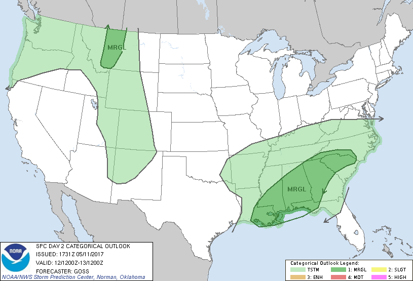
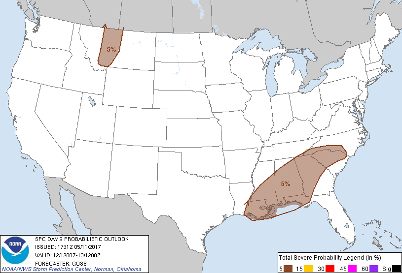
...THERE IS A MARGINAL RISK OF SEVERE THUNDERSTORMS ACROSS PARTS OF
THE SOUTHEAST...
...THERE IS A MARGINAL RISK OF SEVERE THUNDERSTORMS OVER PORTIONS OF
WESTERN AND CENTRAL MONTANA...
...SUMMARY...
Strong storms are possible across portions of the Deep South to the
southern Appalachians, as well as across parts of west-central
Montana on Friday. Gusty winds and hail are the main concerns with
these storms.
...Synopsis...
While a large/deep upper low just off the western Canada/Pacific
Northwest coast early Friday moves slowly inland, cyclonic flow
surrounding a second low -- over western Ontario -- is forecast to
expand southeastward across the Great Lakes region during the
period. Meanwhile, an eastward-moving short-wave trough, south of
aforementioned/southward-expanding northern stream cyclonic flow
field, is progged to shift eastward across the southeast quarter of
the U.S. through the period.
At the surface, a weak cold front is forecast to advance southeast
across the southeast states in conjunction with the eastward-moving
mid-level wave, while in the West a cold front associated with the
inland-moving upper system will cross the Intermountain West through
the period.
...The Southeast...
Showers and embedded thunderstorms should be ongoing at the start of
the period to the northwest of the risk area, in the vicinity of the
southeastward-moving cold front. While clouds and ongoing
precipitation may hinder destabilization across portions of the
area, a moist boundary layer and some heating should yield
mixed-layer CAPE generally in the 1000 to 1500 J/kg range. A
gradual increase in storms is expected through the afternoon, from
portions of the Carolinas west-southwestward to the Louisiana
vicinity, with some linear and/or multicell organization expected
locally -- aided by moderate westerly/west-southwesterly flow at mid
levels. Locally gusty/damaging winds and marginally severe hail
will be possible with the strongest convection, though
anticipated/overall risk does not appear to warrant upgrade to 15%
coverage/SLGT risk at this time.
...Western/central Montana vicinity...
Ascent associated with the eastward advance of upper troughing and
an associated surface cold front will support afternoon storm
develop over western/central Montana, as some high-based CAPE
development occurs in conjunction with daytime heating. With amply
strong/roughly unidirectional southerly flow aloft expected across
the region sufficient to support organized/fast-moving storms, some
risk for locally damaging, evaporatively enhanced gusts will be
possible. Risk should diminish by late evening as the lower
troposphere cools/stabilizes.
..Goss.. 05/11/2017
CLICK TO GET WUUS02 PTSDY2 PRODUCT
NOTE: THE NEXT DAY 2 OUTLOOK IS SCHEDULED BY 0600Z