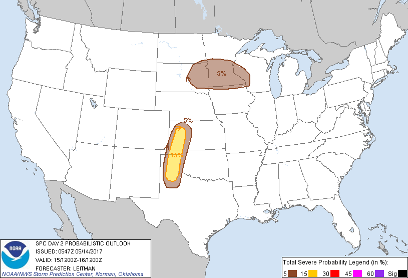
Amarillo, TX...Garden City, KS...Dodge City, KS...Plainview, TX...Liberal, KS...
MARGINAL
107,629
6,256,407
Minneapolis, MN...St. Paul, MN...Lubbock, TX...Sioux Falls, SD...Rochester, MN...
Probabilistic Graphic
Probability of severe weather within 25 miles of a point. Hatched Area: 10% or greater probability of significant severe within 25 miles of a point.
Day 2 Prob. Risk
Area (sq. mi.)
Area Pop.
Some Larger Population Centers in Risk Area
15 %
32,714
565,306
Amarillo, TX...Garden City, KS...Dodge City, KS...Plainview, TX...Liberal, KS...
5 %
107,069
6,233,383
Minneapolis, MN...St. Paul, MN...Lubbock, TX...Sioux Falls, SD...Rochester, MN...
SPC AC 140547
Day 2 Convective Outlook
NWS Storm Prediction Center Norman OK
1247 AM CDT Sun May 14 2017
Valid 151200Z - 161200Z
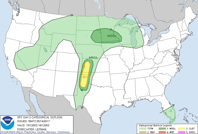
...THERE IS A SLIGHT RISK OF SEVERE THUNDERSTORMS ACROSS PORTIONS OF
THE CENTRAL AND SOUTHERN HIGH PLAINS...
...THERE IS A MARGINAL RISK OF SEVERE THUNDERSTORMS ACROSS MUCH OF
WESTERN KS INTO THE TX SOUTH PLAINS...
...THERE IS A MARGINAL RISK OF SEVERE THUNDERSTORMS ACROSS PARTS OF
THE UPPER MIDWEST...
...SUMMARY...
Isolated severe thunderstorms are expected across parts of western
Kansas into the Texas Panhandle vicinity. Strong winds and large
hail will be the main threat with these storms. Additional strong
storms are possible mainly overnight across parts of eastern South
Dakota, southern and central Minnesota and perhaps far northern Iowa
and west-central Wisconsin. Hail will be the main threat with these
storms.
...Synopsis...
The Pacific coast upper trough will pivot eastward on Monday to the
Great Basin and southwestern deserts. A broad area of enhanced
southwesterly deep-layer flow will stretch from the southern Rockies
through the Plains and into the Upper Midwest. In response to the
eastward progression of the trough, the upper ridge extending from
the upper MS Valley to the Ozarks will shift east of the MS River.
Weak shortwave impulses will migrate through broader southwesterly
flow and, in combination with more substantial height falls after
00z, aid in thunderstorm development across parts of the Upper
Midwest during the nighttime hours. Further south, a surface trough
will extend southward through the central and southern High Plains
and a dryline will be the focus for thunderstorm activity across
parts of western KS into the TX Panhandle vicinity during the late
afternoon/early evening.
...Western KS into the TX Panhandle Vicinity...
A surface trough will sharpen during the afternoon and southeasterly
low level flow will advect moisture northwest across the southern
Plains ahead of a dryline. With the lack of any stronger shortwave
impulse ejecting across the southern Rockies, thunderstorm activity
will be diurnally driven and isolated. However, deep-layer shear
profiles will be sufficient for high-based supercells. Steep
midlevel lapse rates approaching 8.0 deg C/km and moderate
instability will support storms capable of large hail. A deeply
mixed boundary layer to around 700 mb, where flow is progged to be
around 40 kt, also will support strong wind potential. As storms
track east toward the eastern TX Panhandle and adjacent portions of
western KS, loss of daytime heating and increasing capping is
expected to result in rapid weakening of storms near dark.
...Eastern SD, southern/central MN, far northern IA, west-central
WI...
Strong capping should inhibit convection across the warm sector
during the afternoon. A weak surface low will develop over the
northern High Plains and track eastward across SD overnight. A warm
from will extend eastward from the low, with some variability among
deterministic guidance in how far north the front will advance
during the nighttime hours. However, the front should be lifting
northward in the vicinity of eastern SD to southern/central MN and
west-central WI overnight. A south/southwesterly low-level jet will
increase after 00z from the central Plains into the upper MS Valley.
Strong warm advection atop the surface boundary, coupled with
falling midlevel heights, should support elevated thunderstorm
development north of the front. Steeper-than-normal midlevel lapse
rates for this time of year and sufficient deep-layer shear will
support a hail threat with these storms. Given uncertainty in the
location of the surface boundary and lack of stronger forcing aloft,
will introduce only low severe probs at this time.
..Leitman.. 05/14/2017
CLICK TO GET WUUS02 PTSDY2 PRODUCT
NOTE: THE NEXT DAY 2 OUTLOOK IS SCHEDULED BY 1730Z