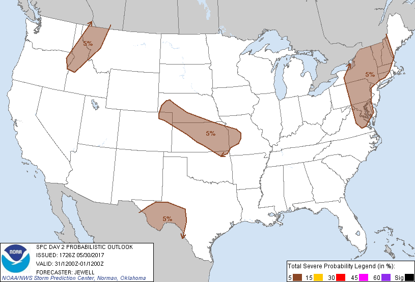
Baltimore, MD...Washington, DC...Kansas City, MO...Wichita, KS...Richmond, VA...
Probabilistic Graphic
Probability of severe weather within 25 miles of a point. Hatched Area: 10% or greater probability of significant severe within 25 miles of a point.
Day 2 Prob. Risk
Area (sq. mi.)
Area Pop.
Some Larger Population Centers in Risk Area
5 %
300,544
33,334,291
Baltimore, MD...Washington, DC...Kansas City, MO...Wichita, KS...Richmond, VA...
SPC AC 301726
Day 2 Convective Outlook
NWS Storm Prediction Center Norman OK
1226 PM CDT Tue May 30 2017
Valid 311200Z - 011200Z
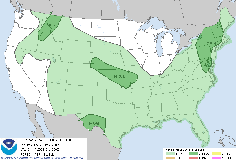
...THERE IS A MARGINAL RISK OF SEVERE THUNDERSTORMS FROM EASTERN
VIRGINIA INTO SOUTHERN NEW ENGLAND...
...THERE IS A MARGINAL RISK OF SEVERE THUNDERSTORMS ACROSS THE
CENTRAL PLAINS...
...THERE IS A MARGINAL RISK OF SEVERE THUNDERSTORMS ACROSS SOUTHWEST
TEXAS...
...THERE IS A MARGINAL RISK OF SEVERE THUNDERSTORMS ACROSS NORTHERN
IDAHO INTO WESTERN MONTANA...
...SUMMARY...
Sporadic marginally severe hail or wind is possible Wednesday across
parts of the Northeast and Mid Atlantic, the central Plains,
southwest Texas, and Idaho into western Montana on.
...Synopsis...
An upper low will remain centered over Hudson bay with broad area of
strong cyclonic flow aloft from the Great Lakes across the
Northeast. To the west, an upper ridge axis will gradually shift
east across the Rockies, with a meridional 50 kt southerly midlevel
jet max moving across ID and MT. To the south, weak upper
troughiness will exist across northern Mexico into the southern High
Plains.
At the surface, high pressure will settle in across the mid MS into
the OH and TN valleys, with a weak lee trough from MT into the
central High Plains. A quasi-stationary front will exist from the
lower Ohio Valley northwestward across NE, with mainly 50s dewpoints
across the central Plains. More substantial low-level moisture will
remain across TX eastward across the Gulf Coast with upper 60s to
lower 70s.
...Northeast CO/Western NEB across KS and into western MO and
northeast OK...
Strong heating will occur south of the boundary, which will steepen
lapse rates dramatically with cold air aloft present. While
dewpoints may only reach the mid/upper 50s, MUCAPE on the order of
1500-2000 J/kg will develop. Generally weak southeasterly low level
flow with modest northwesterly midlevel flow may be enough for a few
longer lived cells, as well as small bowing structures. Storms are
expected to form over KS/MO by late afternoon, as well as across
CO/NEB in the upslope region. There may be a small area worthy of a
Slight risk in later outlooks, perhaps across KS or MO where a
cluster of wind or hail is possible.
...Eastern VA into the Northeast...
Substantial mid to upper level flow will exist across the region,
but the focus for development along a surface trough will be weak.
Alone and ahead of this trough, 50s dewpoints will be common, with
60s from southeast PA into VA. Strong heating will eventually
destabilize the entire area, with no convective inhibition by
afternoon. One area of initiation will likely be across central NY
into PA along the wind shift. Long hodographs would support
splitting cells and/or wind depending on the amount of outflow.
To the south, early showers or storms are expected over the OH
valley, and this area of disturbed weather will shift eastward
across the Appalachians by late afternoon. Any ongoing activity may
re-energize as it encounters greater instability, and/or possible
outflow could help instigate new development farther east. Marginal
hail and wind will be possible.
...Southwest TX...
Southeasterly surface flow will be maintained which will keep the
air mass relatively moist. Relatively cool temperatures aloft will
also exist due to the weak upper trough, with -10 C around 500 mb.
Daytime heating will result in around 1500-2000 J/kg MUCAPE by
afternoon, with scattered thunderstorms likely. Westerly flow aloft
will be weak, but when juxtaposed atop the surface southeasterlies,
may yield enough shear for some multicellular clusters capable of
hail and localized severe wind gusts. Depending on storm coverage
and intensity, some of the outflow could affect the El Paso area,
although instability will be weaker there.
...ID into western MT...
A deepening surface trough will be coincident with the advancing 50
kt meridional midlevel wave. Cooling aloft and heating will result
in steep lapse rates and will maximize instability despite low
levels of moisture. Modest mean wind speeds may be enough for a few
northeastward moving bows with wind, while veering winds with height
in the low-levels suggest perhaps a few lone cells capable of hail.
..Jewell.. 05/30/2017
CLICK TO GET WUUS02 PTSDY2 PRODUCT
NOTE: THE NEXT DAY 2 OUTLOOK IS SCHEDULED BY 0600Z