SPC AC 031728
Day 2 Convective Outlook
NWS Storm Prediction Center Norman OK
1228 PM CDT Sat Jun 03 2017
Valid 041200Z - 051200Z
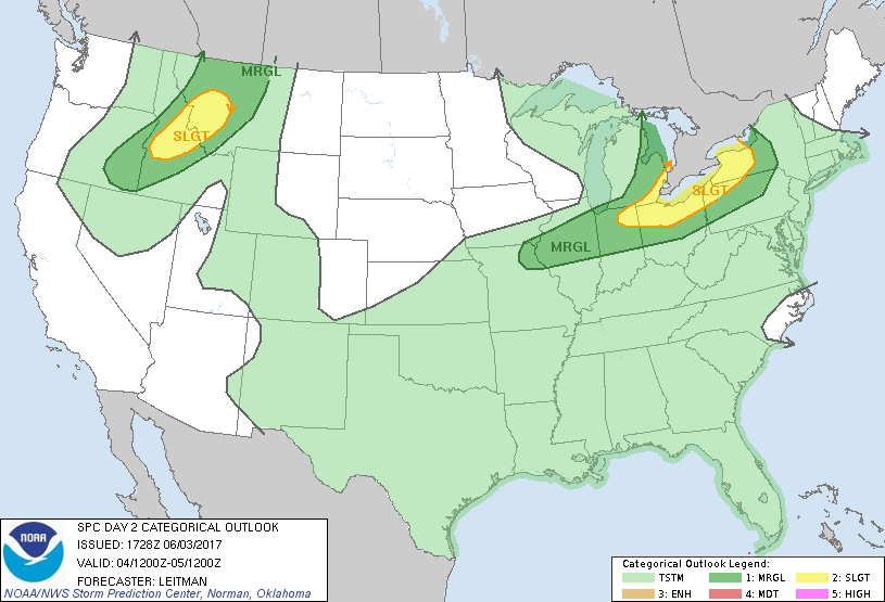
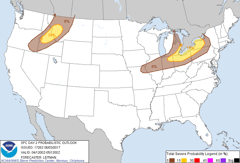
...THERE IS A SLIGHT RISK OF SEVERE THUNDERSTORMS ACROSS PORTIONS OF
THE LOWER GREAT LAKES...
...THERE IS A SLIGHT RISK OF SEVERE THUNDERSTORMS ACROSS PORTIONS OF
THE NORTHERN ROCKIES...
...THERE IS A MARGINAL RISK OF SEVERE THUNDERSTORMS FROM NORTHEAST
MO INTO WESTERN NY...
...THERE IS A MARGINAL RISK OF SEVERE THUNDERSTORMS FROM SOUTHEAST
OR INTO NORTH-CENTRAL MT...
...SUMMARY...
Scattered strong to severe thunderstorms are expected across parts
of the lower Great Lakes and Ohio Valley regions on Sunday. Strong
winds and hail will be the main threats with these storms.
Additional strong to severe thunderstorms are also expected across
the northern Rockies.
...Lower Great Lakes and Mid-MS/OH Valley Vicinity...
A compact upper trough located over the upper Midwest early Sunday
will progress southeastward into the lower Great Lakes and Ohio
Valley vicinity by the end of the period. A surface low will develop
from the upper Great Lakes to western NY and an attendant cold front
will push east/southeast across the Great Lakes region. Showers and
thunderstorms may be ongoing across parts of NY/PA early Sunday.
This activity could pose a marginal wind/hail threat initially. As
shear and forcing for ascent increase during the afternoon,
additional thunderstorm development is expected along the
pre-frontal confluence zone from northeast MO into western NY. Shear
profiles in the vicinity of lakes Ontario and Erie suggest line
segments will be favored with an attendant threat of strong wind
gusts. Some hail also will be possible. Further west toward the
mid-MS Valley, steeper lapse rates will be present. Marginally
severe hail in addition to gusty winds will be possible from
northeast MO into northern IL.
...Northern Rockies...
An upper trough will shift east into the Pacific Northwest by late
afternoon and deep layer shear will increase from eastern OR into
western MT. A cold front will reside from northern ID into eastern
OR early Sunday, and slowly shift east into central MT after
06z/Mon. Pockets of stronger heating ahead of the front will result
in modest destabilization by afternoon and scattered thunderstorms
are expected to develop over higher terrain of southeast OR into
central ID and western MT. Steep midlevel lapse rates and strong
shear will support storms capable of hail. Additionally, a
deeply-mixed/dry sub-cloud layer and fast storm motion could result
in some strong wind gusts. The greatest threat for large hail and
damaging wind gusts appears to exist from the central ID mountains
into parts of western MT where steep midlevel lapse rates, strong
shear and around 1000 J/kg MUCAPE will align, and a slight risk has
been introduced for this area.
..Leitman.. 06/03/2017
CLICK TO GET WUUS02 PTSDY2 PRODUCT
NOTE: THE NEXT DAY 2 OUTLOOK IS SCHEDULED BY 0600Z