Jacksonville, FL...Colorado Springs, CO...Tampa, FL...Aurora, CO...St. Petersburg, FL...
Probabilistic Graphic
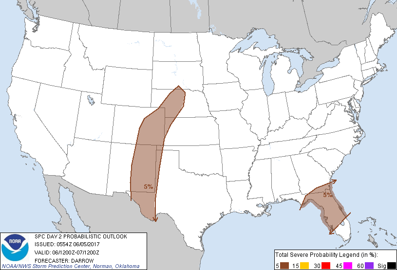
Probability of severe weather within 25 miles of a point. Hatched Area: 10% or greater probability of significant severe within 25 miles of a point.
Day 2 Prob. Risk
Area (sq. mi.)
Area Pop.
Some Larger Population Centers in Risk Area
5 %
216,450
13,949,311
Jacksonville, FL...Colorado Springs, CO...Tampa, FL...Aurora, CO...St. Petersburg, FL...
SPC AC 050554
Day 2 Convective Outlook
NWS Storm Prediction Center Norman OK
1254 AM CDT Mon Jun 05 2017
Valid 061200Z - 071200Z
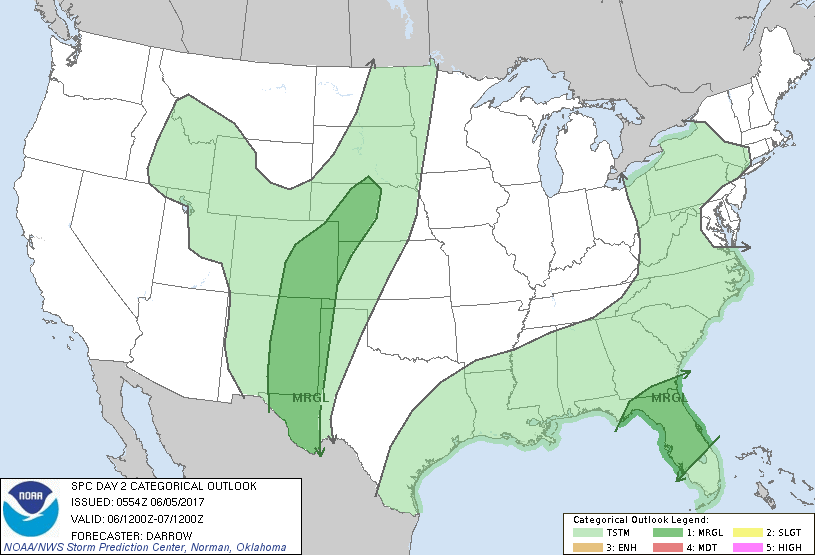
...THERE IS A MARGINAL RISK OF SEVERE THUNDERSTORMS ACROSS THE
CENTRAL/SOUTHERN HIGH PLAINS...
...THERE IS A MARGINAL RISK OF SEVERE THUNDERSTORMS ACROSS FL...
...SUMMARY...
Strong thunderstorms, a few severe, are expected across portions of
the Southeast, including the northern Florida Peninsula. Isolated
severe thunderstorms should also develop across the central and
southern High Plains.
...High Plains...
Mean upper ridge position will hold across the Rockies through the
day2 period with a corridor of modest northwesterly flow expected
along the front side of this feature from southern CO into the Big
Bend region of TX. While a few weak disturbances could migrate
through the ridge it's not readily apparent whether any short-wave
troughs will crest the ridge and dig southeast within the
aforementioned stronger flow across the High Plains. Even so,
thunderstorms are expected to develop across the higher terrain and
adjacent High Plains Tuesday as strong boundary-layer warming forces
surface parcels to their convective temperatures. Additionally,
convection should focus along a southward-moving cold front as it
progresses into NE/CO. Forecast soundings across the MRGL risk
exhibit steep lapse rates and modest instability within a sheared
environment seemingly favorable for loosely organized thunderstorm
clusters. Storm motions should be south-southeast and hail/wind are
the primary threats.
...FL...
Models are in general agreement that an upper low over TX will dig
east-southeast into the northern Gulf Basin, partially in response
to heights falling across the OH Valley/Middle Atlantic region. As a
result, a belt of modest mid-level flow (40kt at 500mb) will develop
across the FL Peninsula, well south of a synoptic front that will
sag into GA/southern AL by 18z. Extensive clouds/precip should
develop in response to this active southern-stream branch over the
Gulf Basin and spread across FL. Limited sunshine will inhibit
boundary-layer heating and poor lapse rates are expected across FL
within an otherwise modestly sheared environment. While buoyancy
will be weak, will maintain 5% severe probs to account for gusty
winds with convection that organizes across this region.
..Darrow.. 06/05/2017
CLICK TO GET WUUS02 PTSDY2 PRODUCT
NOTE: THE NEXT DAY 2 OUTLOOK IS SCHEDULED BY 1730Z