SPC AC 090539
Day 2 Convective Outlook
NWS Storm Prediction Center Norman OK
1239 AM CDT Sun Jul 09 2017
Valid 101200Z - 111200Z
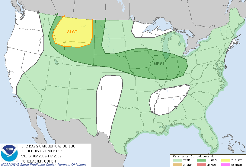
...THERE IS A SLIGHT RISK OF SEVERE THUNDERSTORMS ACROSS PORTIONS OF
MONTANA...EXTREME NORTHERN WYOMING...EXTREME EASTERN IDAHO...
...THERE IS A MARGINAL RISK OF SEVERE THUNDERSTORMS FROM PORTIONS OF
THE NORTHERN ROCKIES AND NORTHERN PLAINS INTO PARTS OF NEBRASKA
EXTENDING EASTWARD INTO THE SOUTHERN GREAT LAKES AND OHIO VALLEY
REGION...
...SUMMARY...
On Monday, severe thunderstorms will be possible from portions of
the northern Rockies and adjacent Plains, eastward across parts of
Nebraska into the Ohio Valley region. The greatest
severe-thunderstorm risk will be across Montana and vicinity, where
widely scattered severe wind and hail will be possible.
...Synopsis...
A low-amplitude midlevel shortwave trough is forecast to track from
the Pacific Northwest to the northern High Plains, with a downstream
band of moderate quasi-zonal flow aloft extending eastward to New
England. Rich moisture will reside over eastern parts of the central
and southern Plains through the Mississippi Valley region and Great
Lakes area -- as far north as a front (convectively augmented in
some areas) stretching from parts of Nebraska to the southern Great
Lakes region.
...Montana, Wyoming, eastern Idaho, the western Dakotas...
Areas of strong diurnal heating are expected ahead of the shortwave
trough, with trough-preceding ascent favoring increased convective
coverage emanating from orographic circulations over the mountains.
Convective activity will subsequently spread over the
deep/well-mixed boundary layer across the adjacent Plains. Despite
limited boundary-layer moisture, steep low/midlevel lapse rates will
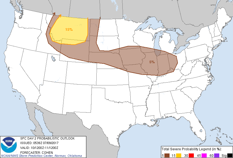
support around 500-1000 J/kg of MLCAPE and robust convective-scale
upward accelerations. With 35-45 kt of midlevel flow across the
added Slight Risk area, sufficient deep shear will support
multicells and weak supercell structures. Deep inverted-V profiles
suggest that widely scattered severe wind will be possible, with
severe hail also possible in association with rotating updrafts.
Given the relatively more predictable evolution of the shortwave
trough, the Slight Risk area has been added. South of the Slight
Risk area, weaker deep shear will exist, though deep and well-mixed
boundary layers will support isolated severe wind gusts across WY
and vicinity. Otherwise, more isolated severe risk will be possible
across the western Dakotas through the period.
...Nebraska eastward to the southern Great Lakes and Ohio Valley
region...
Moderate to strong diurnal destabilization is anticipated south of
the aforementioned front. Where the strongest deep shear is forecast
to exist -- i.e., the southern Great Lakes and Ohio Valley region --
the location and intensity of frontal ascent may be much more
influenced by prior convection lingering into the beginning into the
period. This casts considerable doubt regarding convective evolution
through the period, though the potential for organized convective
development/re-development with severe wind/hail could exist and
linger into the overnight hours.
Farther west through parts of the Midwest into Nebraska and
vicinity, isolated to scattered thunderstorm development is
anticipated near that portion of the front less influenced by
antecedent convection. Despite areas of strong buoyancy, weaker deep
shear is expected to limit severe coverage.
For the aforementioned reasons, a broad corridor of Marginal Risk is
presently depicted. However, some potential for an upgrade may be
considered in subsequent outlooks -- particularly across parts of
the southern Great Lakes region.
..Cohen.. 07/09/2017
CLICK TO GET WUUS02 PTSDY2 PRODUCT
NOTE: THE NEXT DAY 2 OUTLOOK IS SCHEDULED BY 1730Z