SPC AC 161715
Day 2 Convective Outlook
NWS Storm Prediction Center Norman OK
1215 PM CDT Wed Aug 16 2017
Valid 171200Z - 181200Z
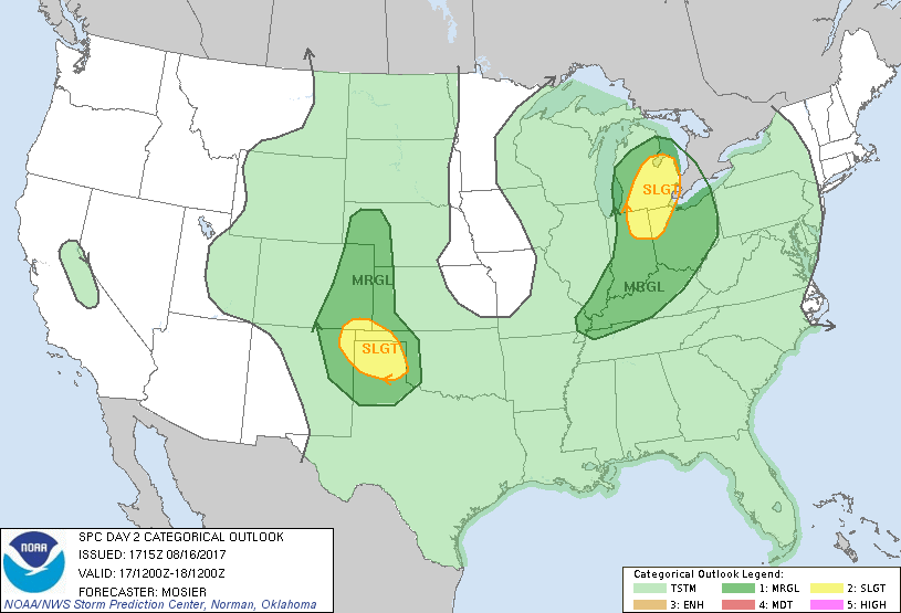
...THERE IS A SLIGHT RISK OF SEVERE THUNDERSTORMS OVER PORTIONS OF
LOWER MI...NORTHEAST IN AND NORTHWEST OH...
...THERE IS A SLIGHT RISK OF SEVERE THUNDERSTORMS OVER PORTIONS OF
THE SOUTHERN HIGH PLAINS...
...THERE IS A MARGINAL RISK OF SEVERE THUNDERSTORMS OVER PORTIONS OF
THE OH VALLEY AND LOWER MI...
...THERE IS A MARGINAL RISK OF SEVERE THUNDERSTORMS OVER PORTIONS OF
THE SOUTHERN AND CENTRAL HIGH PLAINS...
...SUMMARY...
Thunderstorms, some severe, are expected across the Ohio Valley into
lower Michigan. Scattered thunderstorms are also expected across the
central and southern High Plains, where some severe storms are also
possible.
...Synopsis...
A well-defined, seasonally strong shortwave trough will progress
through the upper Midwest and into the upper Great Lakes region,
while maturing, during the period. Consensus amongst the guidance
suggests the surface low associated with this upper system will be
near the central portions of the MN/WI border at 12Z Thursday, with
an attendant cold front stretching from the low southward through
central IA and then southwestward back through central OK and into
the southern TX Panhandle. Another shortwave trough is expected to
move quickly into the northern Plains tomorrow night.
...Middle MS Valley...OH Valley...Lower MI...
Showers and thunderstorms will likely be ongoing at the beginning of
the period within the WAA zone near the surface low across northern
WI and upper MI. However, farther south, general expectation is for
the portion of the front moving across the middle MS Valley to be
mostly void of thunderstorm activity, largely a result of being
displaced south of the strongest forcing for ascent but north of the
better instability. A reinvigoration of thunderstorms is expected
across lower MI and the central OH Valley as the cold front
encounters the moist and diurnally destabilized airmass across the
region. A predominately multicell mode is anticipated with possible
embedded bowing structures contributing to occasional damaging wind
gusts. Some isolated hail is also possible within the more organized
storms. Relatively higher coverage is possible across lower MI and
adjacent portions of northeast IN/northwest OH where slightly
stronger shear supports a more favorable environment for storm
organization/higher potential for a supercell or two. Given the
amount of low-level moisture and relatively strong 850mb flow, a
tornado or two is also possible. As a result, a Slight Risk has been
introduced across these areas.
...Central/Southern High Plains...
Far western extent of the front discussed in the synopsis will be
very defuse at the beginning of the period across portion of the
southern TX Panhandle. Lee troughing across the High Plains will
encourage modest moisture return into the southern/central High
Plains. Additionally, shortwave trough moving through MT and into
the northern Plains will provide at least modest forcing for ascent
throughout the High Plains during the late afternoon and evening.
Good directional shear (0-6km bulk shear around 30-40 kt) and
moderate instability (i.e. MLCAPE from 2000-2500 J/kg) across the
southern High Plains will support thunderstorm organization and
enough severe storm coverage to merit a Slight Risk. More isolated
severe coverage is anticipated farther north into the central High
Plains. Large hail will be the primary severe threat for the first
few hours of development during the late afternoon with the threat
then transition to strong wind gusts as storms become more linear.
..Mosier.. 08/16/2017
CLICK TO GET WUUS02 PTSDY2 PRODUCT
NOTE: THE NEXT DAY 2 OUTLOOK IS SCHEDULED BY 0600Z