New York, NY...Philadelphia, PA...Baltimore, MD...Washington, DC...Kansas City, MO...
Probabilistic Graphic
Probability of severe weather within 25 miles of a point. Hatched Area: 10% or greater probability of significant severe within 25 miles of a point.
Day 2 Prob. Risk
Area (sq. mi.)
Area Pop.
Some Larger Population Centers in Risk Area
5 %
167,003
43,402,284
New York, NY...Philadelphia, PA...Baltimore, MD...Washington, DC...Kansas City, MO...
SPC AC 170510
Day 2 Convective Outlook
NWS Storm Prediction Center Norman OK
1210 AM CDT Thu Aug 17 2017
Valid 181200Z - 191200Z
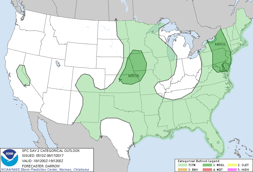
...THERE IS A MARGINAL RISK OF SEVERE THUNDERSTORMS FROM THE MIDDLE
ATLANTIC INTO UPSTATE NY...
...THERE IS A MARGINAL RISK OF SEVERE THUNDERSTORMS ACROSS THE MID
MO VALLEY REGION...
...SUMMARY...
Scattered thunderstorms, a few possibly severe, are expected from
the Middle Atlantic into Upstate New York. Isolated severe
thunderstorms are also expected across the mid Missouri Valley
region.
...Middle Atlantic/Upstate NY...
Central Plains short-wave trough will translate into the OH Valley
by the beginning of the day2 period. Associated surface front is
expected to migrate to a position from southern ON, south across
western PA into WV by 18z. High PW air mass will extend across the
warm sector ahead of the wind shift and large-scale forcing for
ascent will encourage considerable amount of frontal convection that
should be ongoing at the start of the period. Latest short-range
guidance suggests modest boundary-layer heating should occur from
western VA, north into Upstate NY where surface-3km lapse rates
could exceed 7 C/km. As a result, adequate buoyancy is expected
along this corridor for robust thunderstorm development by early
afternoon. With deep-layer shear expected to increase ahead of the
front it appears organized convection is possible and damaging winds
could be noted with the strongest convection. Have expanded 5%
severe probs south into the Delmarva where modest instability will
exist along southern periphery of stronger forcing. SLGT risk may
need to be added to this region if later guidance continues to
suggest thermodynamic profiles will support strong updrafts.
...Mid MO Valley Region...
Strong short-wave trough is expected to dig southeast across the
northern Plains into the mid MO Valley by late afternoon. 500mb flow
in excess of 40kt should extend across eastern NE into IA coincident
with isolated convection that should evolve ahead of a weak surface
front that will extend from the SD/MN border, south into
north-central KS. Strong boundary-layer heating will be noted across
the plains and cooling temperatures aloft will enhance lapse rates
within strongly sheared environment. While low-level convergence
will not be particularly strong, isolated thunderstorms should
evolve ahead of the short wave then track southeast toward northwest
MO. Hail/wind are the primary threats with this activity.
..Darrow.. 08/17/2017
CLICK TO GET WUUS02 PTSDY2 PRODUCT
NOTE: THE NEXT DAY 2 OUTLOOK IS SCHEDULED BY 1730Z