SPC AC 051726
Day 2 Convective Outlook
NWS Storm Prediction Center Norman OK
1226 PM CDT Thu Oct 05 2017
Valid 061200Z - 071200Z
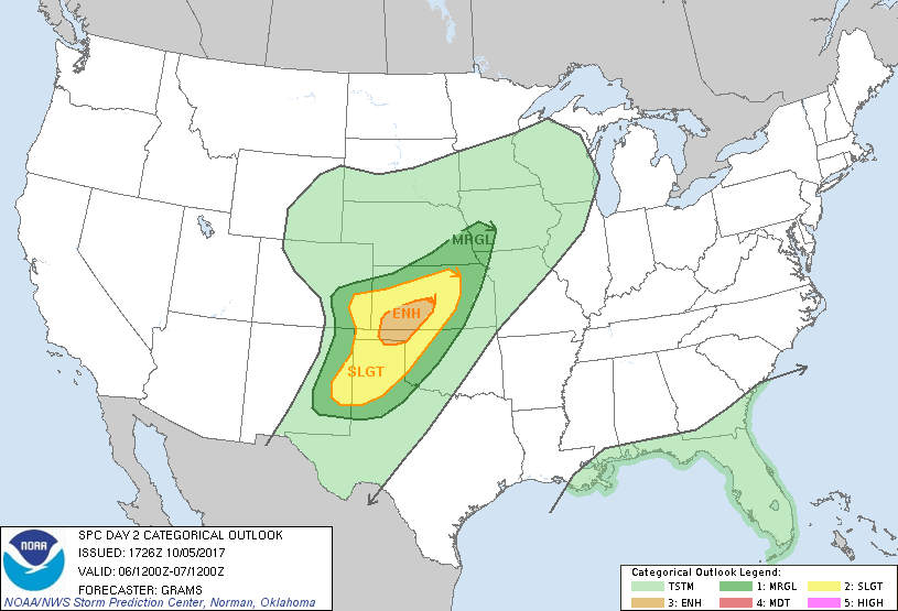
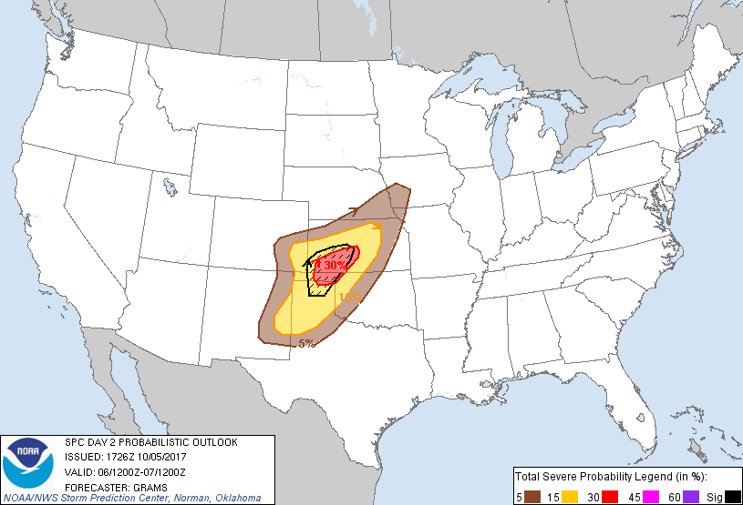
...THERE IS AN ENHANCED RISK OF SEVERE THUNDERSTORMS SOUTHWEST KS
AND OK PANHANDLE...
...THERE IS A SLIGHT RISK OF SEVERE THUNDERSTORMS KS AND SOUTHEAST
CO TO EASTERN NM AND TX PANHANDLE...
...THERE IS A MARGINAL RISK OF SEVERE THUNDERSTORMS LOWER MO VALLEY
TO SOUTHERN HIGH PLAINS...
...SUMMARY...
Scattered severe storms are likely from parts of Kansas and
southeast Colorado south across the Texas Panhandle into eastern New
Mexico during the late afternoon and evening on Friday. Very large
hail, a few tornadoes, and damaging winds will be possible.
...Synopsis...
A shortwave trough will amplify as it progresses east from the Great
Basin into the central Great Plains through early Saturday. A belt
of strengthening mid-level west-southwesterlies will accompany this
amplification, becoming centered over the southern High Plains to
Lower MO Valley by Friday evening. Lee surface cyclone should deepen
in the Raton Mesa vicinity with a quasi-stationary front extending
northeast across KS into southeast NE. This boundary will accelerate
southeast as a cold front Friday evening as the shortwave trough and
a Pacific cold front ejects onto the Plains.
...Central and southern Great Plains...
Have upgraded to Enhanced risk and expanded/shifted Slight/Marginal
risk areas west/north.
Rich boundary-layer moisture characterized by 60s surface dew points
will reside south of the aforementioned front. Unlike a typical
widespread severe day in the Plains, mid-level lapse rates should
remain modest outside of the central High Plains. As such, diabatic
heating will be necessary to boost buoyancy and as surface
temperatures warm into the 80s, MLCAPE will reach 1000-2000 J/kg.
Mid-level height falls/DCVA will initially overspread the High
Plains portion of the region, aiding in scattered storms developing
near the surface cyclone late afternoon/early evening. Convective
coverage should increase during the evening east along the KS
portion of the front, and south along the impinging Pacific cold
front over eastern NM and northwest TX.
40-50 kt effective shear and increasingly elongated hodographs with
very strong mid/upper-level speed shear will support several
supercells, a couple of which may become long-track/intense in the
southwest KS to northern TX Panhandle vicinity. Significant severe
hail appears to be the primary hazard, especially given the highly
favorable wind profiles in the hail growth zone. A couple-hour
window will also exist for a few tornadoes. However, somewhat veered
and initially moderate low-level winds should be limiting factors to
greater coverage of the tornado threat. Given the strength of the
forcing within the frontal zones, upscale growth into bowing line
segments appears probable within a few hours of initiation, yielding
a predominant mix of severe wind/hail. Towards midnight, storm
intensity should rapidly wane owing to minimal instability east of
the TX Big Country to eastern KS.
..Grams.. 10/05/2017
CLICK TO GET WUUS02 PTSDY2 PRODUCT
NOTE: THE NEXT DAY 2 OUTLOOK IS SCHEDULED BY 0600Z