Oklahoma City, OK...Overland Park, KS...Springfield, MO...Olathe, KS...Independence, MO...
SPC AC 230712
Day 3 Convective Outlook
NWS Storm Prediction Center Norman OK
0212 AM CDT Sun Apr 23 2017
Valid 251200Z - 261200Z
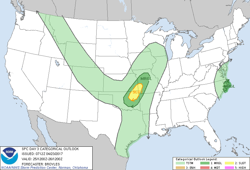
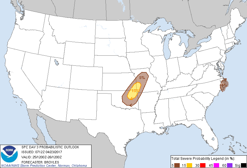
...THERE IS A SLIGHT RISK OF SEVERE THUNDERSTORMS ACROSS PARTS OF
NORTHEAST OKLAHOMA...SOUTHEAST KANSAS AND SOUTHWEST MISSOURI...
...THERE IS A MARGINAL RISK OF SEVERE THUNDERSTORMS OUTSIDE OF THE
SLIGHT RISK AREA ACROSS PARTS OF NORTHEAST OKLAHOMA...SOUTHEAST
KANSAS AND SOUTHWEST MISSOURI...
...THERE IS A MARGINAL RISK OF SEVERE THUNDERSTORMS ACROSS PARTS OF
EASTERN NORTH CAROLINA...
...SUMMARY...
Thunderstorms associated with large hail and isolated wind damage
are expected to develop across parts of northeast Oklahoma,
southeast Kansas and southwest Missouri late Tuesday afternoon into
the evening. Other marginally severe storms with strong wind gusts
may occur across eastern North Carolina.
...Oklahoma/Southeast Kansas/southwest Missouri...
An upper-level trough is forecast to move east-southeastward across
the southern and central Rockies into the High Plains on Tuesday. At
the surface, a cold front is forecast to advance southeastward
across the central Plains during the day reaching northern Oklahoma
and western Missouri by early evening. A capping inversion should
prevent convective initiation along the front during the afternoon.
The cap should weaken by early evening allowing for thunderstorm
development to take place in southwest Missouri and southeast
Kansas. This convection is expected to develop southwestward into
northeastern Oklahoma during by mid evening.
GFS forecast soundings along this corridor at 03Z/Wednesday from
Springfield to Tulsa show moderate instability (MLCAPE near 2000
J/kg), 0-6 km shear around 50 kt and steep lapse rates from 700 to
500 mb. This should support supercell development with large hail.
An isolated wind-damage threat should also accompany supercells and
with the stronger multicell line-segments that organize along the
front.
...Eastern North Carolina...
An upper-level low is forecast to move northeastward, offshore but
parallel to the North Carolina coast on Tuesday. At the surface, a
corridor of low-level moisture is forecast in eastern North Carolina
where convection may develop during the morning into early
afternoon. Although instability is forecast to remain weak, moderate
deep-layer shear and the moist boundary layer could be enough for
marginally severe wind gusts with the stronger multicells.
..Broyles.. 04/23/2017
CLICK TO GET WUUS03 PTSDY3 PRODUCT
NOTE: THE NEXT DAY 3 OUTLOOK IS SCHEDULED BY 0730Z