Philadelphia, PA...Baltimore, MD...Washington, DC...Newark, NJ...Jersey City, NJ...
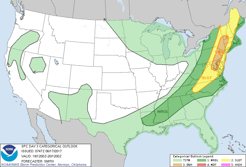
SLIGHT
133,085
33,266,661
New York, NY...Greensboro, NC...Winston-Salem, NC...Richmond, VA...Worcester, MA...
MARGINAL
267,397
37,097,780
Charlotte, NC...Boston, MA...Virginia Beach, VA...Atlanta, GA...Raleigh, NC...
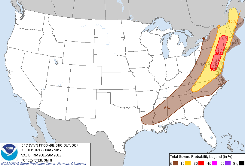
Probabilistic Graphic
Probability of severe weather within 25 miles of a point. Hatched Area: 10% or greater probability of significant severe within 25 miles of a point.
Day 3 Prob. Risk
Area (sq. mi.)
Area Pop.
Some Larger Population Centers in Risk Area
30 %
35,766
25,370,759
Philadelphia, PA...Baltimore, MD...Washington, DC...Newark, NJ...Jersey City, NJ...
15 %
132,838
33,233,201
New York, NY...Greensboro, NC...Winston-Salem, NC...Richmond, VA...Worcester, MA...
5 %
267,680
37,152,322
Charlotte, NC...Boston, MA...Virginia Beach, VA...Atlanta, GA...Raleigh, NC...
   SPC AC 170747

   Day 3 Convective Outlook
   NWS Storm Prediction Center Norman OK
   0247 AM CDT Sat Jun 17 2017

   Valid 191200Z - 201200Z

   ...THERE IS AN ENHANCED RISK OF SEVERE THUNDERSTORMS FROM THE
   CHESAPEAKE BAY VICINITY NORTH INTO THE LOWER HUDSON VALLEY AND PARTS
   OF SOUTHERN NEW ENGLAND...

   ...THERE IS A SLIGHT RISK OF SEVERE THUNDERSTORMS FROM WESTERN NORTH
   CAROLINA NORTHWARD INTO NEW ENGLAND...

   ...THERE IS A MARGINAL RISK OF SEVERE THUNDERSTORMS FROM THE LOWER
   MISSISSIPPI VALLEY INTO THE SOUTHERN APPALACHIANS AND THE
   NORTHEAST...

   ...SUMMARY...
   Scattered to numerous strong to severe thunderstorms are possible
   across portions of the Northeast into the Mid-Atlantic states mainly
   Monday afternoon into the early evening.  Damaging wind gusts will
   be the primary severe hazard but large hail is possible.

   ...Synopsis...
   A large-scale mid-level trough will remain over the Great Lakes with
   strong cyclonic flow located over the southern semicircle of the
   trough.  An upper-level disturbance is forecast to rapidly move from
   the Upper Midwest to northern Indiana by early evening and into the
   lower Great Lakes overnight Monday.  At the surface, a cold
   front/effective boundary will move east across parts of NY/PA and
   the central Appalachians and Mid-Atlantic region with the trailing
   portion of the boundary across the lower MS Valley.

   ...western Carolinas northward into New England...
   Clusters of showers/thunderstorms will likely be ongoing from the OH
   Valley southwest into portions of the lower MS Valley.  Despite
   relatively weak mid-level lapse rates, ample low-level moisture
   (surface dewpoints ranging from the 60s-lower 70s degrees F from
   north to south) combined with strong heating to the east of the
   early-day convection, will contribute to moderate destabilization.
   Models show neutral to weak 500-mb height falls and 30-40 kt
   southwesterly 500-mb flow overspreading the western portion of the
   warm sector during afternoon.  Developing bands of strong to severe
   thunderstorms are forecast with isolated to scattered 50-65 mph
   gusts expected to result in several corridors of scattered wind
   damage from the more intense thunderstorms.  Marginally severe hail
   will be possible, especially with more discrete cellular activity.
   The storm clusters will likely move towards the Mid-Atlantic coast
   and through the lower Hudson Valley during the evening.  The loss of
   heating and the cooler/more stable marine influence near the
   immediate coast in southern New England may temper the overall
   severe risk, as storms move into the region from the west primarily
   after dark.

   ...Deep South...
   Widely scattered diurnal thunderstorms are forecast to
   develop/regenerate along old outflow during the afternoon.  The
   moist/unstable boundary layer will probably support several more
   intense thunderstorms capable of localized damaging gusts and
   perhaps marginally severe hail, with this threat diminishing during
   the evening.

   ..Smith.. 06/17/2017

   CLICK TO GET WUUS03 PTSDY3 PRODUCT

   NOTE: THE NEXT DAY 3 OUTLOOK IS SCHEDULED BY 0730Z