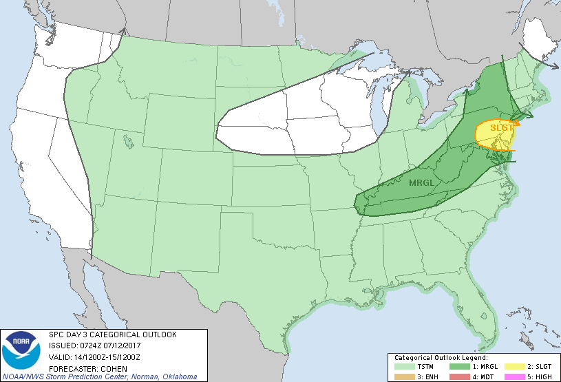
Philadelphia, PA...Baltimore, MD...Toms River, NJ...Allentown, PA...Edison, NJ...
MARGINAL
226,637
47,151,361
New York, NY...Washington, DC...Nashville, TN...Pittsburgh, PA...Newark, NJ...
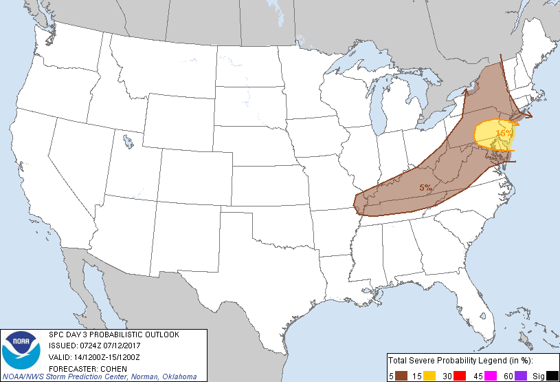
Probabilistic Graphic
Probability of severe weather within 25 miles of a point. Hatched Area: 10% or greater probability of significant severe within 25 miles of a point.
Day 3 Prob. Risk
Area (sq. mi.)
Area Pop.
Some Larger Population Centers in Risk Area
15 %
26,980
17,206,335
Philadelphia, PA...Baltimore, MD...Toms River, NJ...Allentown, PA...Edison, NJ...
5 %
226,565
47,128,198
New York, NY...Washington, DC...Nashville, TN...Pittsburgh, PA...Newark, NJ...
   SPC AC 120724

   Day 3 Convective Outlook
   NWS Storm Prediction Center Norman OK
   0224 AM CDT Wed Jul 12 2017

   Valid 141200Z - 151200Z

   ...THERE IS A SLIGHT RISK OF SEVERE THUNDERSTORMS FROM PARTS OF
   EAST-CENTRAL AND SOUTHEAST PA AND CENTRAL MD EASTWARD TO NJ AND
   DE...

   ...THERE IS A MARGINAL RISK OF SEVERE THUNDERSTORMS FROM PORTIONS OF
   THE OHIO VALLEY VICINITY TO THE MID-ATLANTIC COAST AND MUCH OF NEW
   YORK...

   ...SUMMARY...
   On Friday, widely scattered damaging winds will possible be across
   northern parts of the mid-Atlantic region. More isolated severe
   thunderstorms will be possible elsewhere from portions of the Ohio
   Valley vicinity to the mid-Atlantic coast and much of New York.

   ...Synopsis...
   A mid-level shortwave trough and attendant surface low pressure are
   forecast to track from the Great Lakes region to New England. A warm
   front will develop northward in advance of the low, with
   precipitation reinforcing the effective position of this boundary. A
   cold front will trail southwest of the low to the Mid-South region,
   with this boundary extending westward into the central Plains.

   ...Portions of the Ohio Valley vicinity to the mid-Atlantic coast
   and much of New York...
   Destabilization within the warm sector attendant to the surface low
   will be encouraged by areas of filtered insolation amid rich
   moisture -- e.g., surface dewpoints in the lower 70s -- despite poor
   mid-level lapse rates. Present indications are that the mutual
   overlap of substantive destabilization -- e.g., MLCAPE around
   1000-2000 J/kg -- and enhanced deep shear accompanying the shortwave
   trough -- e.g., 30-40 kt of effective shear -- will be focused from
   parts of east-central and southeast PA and central MD eastward to NJ
   and DE. This is the most-likely area for damaging-wind potential
   associated with organized convective structures (multicells and weak
   supercells). This will be aided by convective momentum transport
   amid the enhanced the low-level mass response accompanying the
   mid-level wave. The northern bound of the corridor of greatest
   destabilization will be influenced by the position of the
   cloud/precipitation-reinforced baroclinic zone/warm front -- for
   which uncertainty remains. This will be a zone of enhanced low-level
   SRH -- potentially bolstering the risk for storm-scale circulations
   on the warm side of this zone. Adjustments to the areal delineation
   of the Slight Risk area could become necessary in subsequent
   outlooks.

   Favorably enhanced deep shear will conditionally support at least
   isolated severe potential north of the Slight Risk area into a large
   part of NY. However, uncertainty regarding the magnitude of
   destabilization, owing to the potential for persistent cloud
   coverage and convective overturning to mute diurnal destabilization,
   precludes more than Marginal-caliber severe probabilities at this
   time.

   Scattered to numerous convection will likely form in the moist
   environment along and ahead of the cold front trailing southwest
   into the Ohio Valley region, with activity subsequently spreading
   eastward to southward. Isolated damaging-wind potential could
   accompany this activity where low-level lapse rates most appreciably
   steepen. However, the overall severe risk is expected to be tempered
   by weak deep shear, which will limit convective organization.

   ..Cohen.. 07/12/2017

   CLICK TO GET WUUS03 PTSDY3 PRODUCT

   NOTE: THE NEXT DAY 3 OUTLOOK IS SCHEDULED BY 0730Z