View What is a Watch? clip.

   ZCZC SPCPWOSPC ALL
   WOUS40 KWNS 051251
   ALZ000-GAZ000-KYZ000-SCZ000-TNZ000-051800-

   PUBLIC SEVERE WEATHER OUTLOOK
   NWS STORM PREDICTION CENTER NORMAN OK
   0751 AM CDT WED APR 05 2017

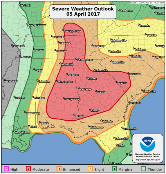
   ...Severe thunderstorms expected over parts of the Southeast States
   to the Ohio Valley region today and tonight...

   * LOCATIONS...
     Georgia
     Alabama
     Middle and eastern Tennessee
     South Carolina
     Central and southern Kentucky

   * HAZARDS...
     Several tornadoes, a few intense
     Widespread large hail, some baseball size
     Scattered damaging winds

   * SUMMARY...
     An outbreak of severe thunderstorms with a few strong tornadoes,
     very large hail, and damaging winds is expected today into
     tonight from Alabama and Georgia into South Carolina, as well as
     northward into middle and eastern Tennessee and central
     Kentucky.

   Preparedness actions...

   Review your severe weather safety procedures for the possibility
   of dangerous weather today. Stay tuned to NOAA Weather Radio,
   weather.gov, or other media for watches and warnings. A tornado
   watch means that conditions are favorable for tornadoes to form
   during the next several hours. If a tornado warning is issued for
   your area, move to a place of safety, ideally in a basement or
   interior room on the lowest floor of a sturdy building.

   &&

   ..Cohen.. 04/05/2017

   $$