New Orleans, LA...Baton Rouge, LA...Metairie, LA...Lafayette, LA...Gulfport, MS...
MARGINAL
41,577
4,045,238
Mobile, AL...Tallahassee, FL...Clearwater, FL...Spring Hill, FL...Largo, FL...
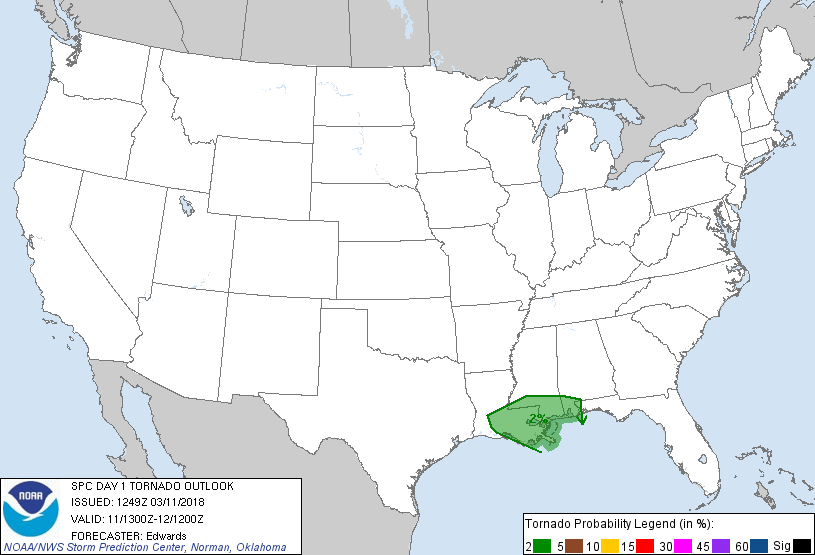
Probabilistic Tornado Graphic
Probability of a tornado within 25 miles of a point. Hatched Area: 10% or greater probability of EF2 - EF5 tornadoes within 25 miles of a point.
Day 1 Tornado Risk
Area (sq. mi.)
Area Pop.
Some Larger Population Centers in Risk Area
2 %
38,507
4,641,022
New Orleans, LA...Baton Rouge, LA...Mobile, AL...Metairie, LA...Lafayette, LA...
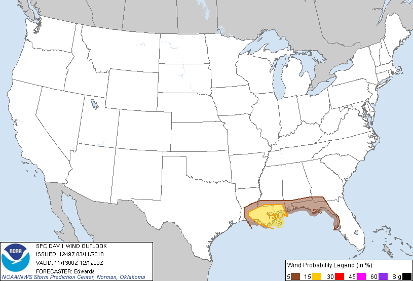
Probabilistic Damaging Wind Graphic
Probability of damaging thunderstorm winds or wind gusts of 50 knots or higher within 25 miles of a point. Hatched Area: 10% of greater probability of wind gusts 65 knots or greater within 25 miles of a point.
Day 1 Wind Risk
Area (sq. mi.)
Area Pop.
Some Larger Population Centers in Risk Area
15 %
28,725
3,514,052
New Orleans, LA...Baton Rouge, LA...Metairie, LA...Lafayette, LA...Gulfport, MS...
5 %
41,154
4,018,438
Mobile, AL...Tallahassee, FL...Clearwater, FL...Spring Hill, FL...Largo, FL...
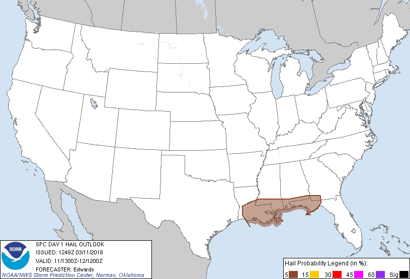
Probabilistic Large Hail Graphic
Probability of hail 1" or larger within 25 miles of a point. Hatched Area: 10% or greater probability of hail 2" or larger within 25 miles of a point.
Day 1 Hail Risk
Area (sq. mi.)
Area Pop.
Some Larger Population Centers in Risk Area
5 %
64,119
6,417,118
New Orleans, LA...Baton Rouge, LA...Mobile, AL...Tallahassee, FL...Metairie, LA...
SPC AC 111249
Day 1 Convective Outlook
NWS Storm Prediction Center Norman OK
0749 AM CDT Sun Mar 11 2018
Valid 111300Z - 121200Z
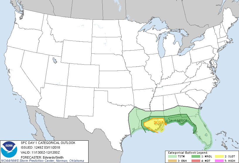
...THERE IS A SLIGHT RISK OF SEVERE THUNDERSTORMS OVER SOUTHERN
PORTIONS OF LOUISIANA AND MISSISSIPPI...
...THERE IS A MARGINAL RISK OF SEVERE THUNDERSTORMS ELSEWHERE FROM
CENTRAL LOUISIANA TO EXTREME SOUTHWESTERN GEORGIA AND NORTHWESTERN
FLORIDA...
...SUMMARY...
Damaging wind gusts and isolated large hail are possible this
morning and afternoon across parts of the central Gulf Coast states,
centered over Louisiana and southern Mississippi. Isolated severe
weather is possible across the remainder of the area extending into
northwestern Florida.
...Synopsis...
The upper-air pattern features split flow over western North
America, with high-amplitude synoptic ridging from the northern
Rockies to western Canada, and an "undercutting" fetch of nearly
zonal flow across the Southwest, southern Plains and Southeast. A
strong shortwave trough -- now evident in moisture-channel imagery
over parts of IA, MO and KS -- is forecast to amplify and move
southeastward by 00Z to KY, western TN, northern MS, and the
Arklatex region. An embedded, 500-mb closed low should develop over
the Tennessee Valley region as the trough continues digging
southeastward, reaching GA, the FL Panhandle and the northeastern/
central Gulf by 12Z. The re-establishment of mean eastern troughing
will be aided further by southeastward motion and amplification of a
strong northern-stream shortwave trough/low, from the western Hudson
Bay/northwestern ON area to the upper Great Lakes.
At the surface, a weak wave low was evident over east-central TX,
along a cold front drawn from western TN through the Arklatex across
the Edwards Plateau and far west TX. A marine frontal zone was
drawn offshore from the Carolinas and northern FL, wrapping across
the south-central Peninsula then northwestward over the northeastern
Gulf, becoming diffuse over the southeastern LA/southern MS region.
The frontal-wave low should reach middle/eastern TN by 00Z, with
cold front southwestward across northern AL, southern MS, and
southeastern LA. By 12Z, a new wave cyclone should form along the
marine front over the Atlantic, offshore from the Carolinas, with
cold front southwestward across extreme northern FL and the
central/northeastern Gulf. The pre-cold-frontal segment of the Gulf
marine front may reach portions of the west-central/northwestern
peninsular coast late in the period before being overtaken by the
synoptic cold front.
...Gulf coastal plain, lower Delta...
Initial outlook adjustments are based on intensity and timing trends
with ongoing convection -- primarily a wavy band of thunderstorms
located from southern portions of AL/MS across central LA to east
TX. This activity, which should remain largely prefrontal in
placement and quasi-linear in mode, is expected to proceed
southeastward into a gradually destabilizing boundary layer before
moving obliquely offshore from LA, MS, AL and the FL Panhandle
through this afternoon. Damaging gusts will be the main concern,
and a rogue/brief tornado cannot be ruled out. The hail potential
appears to be limited by weak lapse rates and largely unsuitable
convective mode; therefore, those probabilities have been decreased.
The antecedent westerly to west-northwesterly flow aloft, combined
with inertial forcing from storm-top divergence, has spread anvil
material over much of the outlook area, which will mute (but not
eliminate) direct diabatic surface heating. Still, when combined
with low-level theta-e advection, forecast soundings suggest parcels
over the LA/MS part of the outlook area will become effectively
surface-based through midday, prior to the arrival of the convective
band, amidst roughly 50-kt effective-shear vectors. A wedge of
500-1000 J/kg preconvective MLCAPE should develop -- narrowing and
decreasing in magnitude with eastward extent in tune with the
observed weakening of low/middle-level lapse rates in morning RAOBs.
Northeastward progress of the marine front will be slow as well,
limiting inland penetration of optimally moist air eastward toward
southeastern AL, southern GA and the central/eastern FL Panhandle,
where severe potential looks much more marginal and conditional.
Strong/isolated severe thunderstorms forming late tonight over the
Gulf may reach parts of coastal northwestern FL before weakening.
..Edwards/Smith.. 03/11/2018
CLICK TO GET WUUS01 PTSDY1 PRODUCT
NOTE: THE NEXT DAY 1 OUTLOOK IS SCHEDULED BY 1630Z