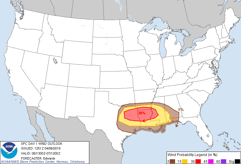
Probability of damaging thunderstorm winds or wind gusts of 50 knots or higher within 25 miles of a point. Hatched Area: 10% of greater probability of wind gusts 65 knots or greater within 25 miles of a point.
Houston, TX...Austin, TX...Baton Rouge, LA...Little Rock, AR...Jackson, MS...
SPC AC 061251
Day 1 Convective Outlook
NWS Storm Prediction Center Norman OK
0751 AM CDT Fri Apr 06 2018
Valid 061300Z - 071200Z
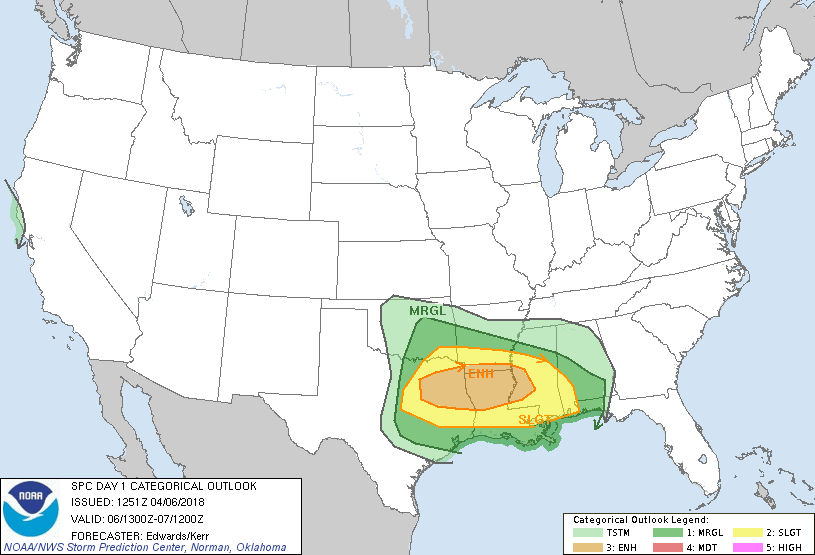
...THERE IS AN ENHANCED RISK OF SEVERE THUNDERSTORMS FROM PARTS OF
NORTH-CENTRAL/NORTHEAST TEXAS TO WEST-CENTRAL MISSISSIPPI...
...THERE IS A SLIGHT RISK OF SEVERE THUNDERSTORMS ELSEWHERE FROM
NORTH-CENTRAL/EAST TEXAS TO PARTS OF SOUTHERN ALABAMA...
...THERE IS A MARGINAL RISK OF SEVERE THUNDERSTORMS SURROUNDING THE
SLIGHT RISK...
...SUMMARY...
Severe thunderstorms with damaging winds, occasional hail, and a few
tornadoes, are possible today from parts of north-central/northeast/
east Texas to the lower Mississippi Valley and central Gulf Coast
regions.
...Synopsis...
In mid/upper levels, broadly cyclonic flow is forecast to persist
over most of the country east of the Rockies, while a high-amplitude
synoptic-scale ridge extends down the Pacific Coastal states/
provinces from Yukon. A well-defined shortwave trough and embedded
mid/upper cyclone were evident in moisture-channel imagery north-
northeast of HI and west of CA, between 150-155W. This feature
should intensify into a strong cyclone aloft through the period and
move east-northeastward toward the coastal Pacific Northwest, making
landfall there on day-2. Well downstream, a subtle shortwave trough
was apparent over the central/southern High Plains, in the broader-
scale cyclonic-flow field. This feature is forecast to proceed
east-southeastward, reaching the southernmost Appalachians by 12Z,
and phasing with weaker/upstream vorticity maxima to form a
positively tilted 500-mb trough from near the TN/NC border to
southern LA.
At the surface, 11Z analysis showed a cold front from Lower MI
across southern portions of IL/MO to central OK, the TX Panhandle,
and southern CO, becoming quasistationary in the Rockies across
central/northern CO, western WY and the ID/MT border region. A weak
low was evident along the front over northwest TX/southwest OK, with
a warm/marine front extending from the northern fringes of the DFW
Metroplex across the TYR/LFK areas to near BPT and the LA shelf
waters. The frontal-wave low is forecast to shift/redevelop
eastward through the day, likely modulated to some extent by
convective processes, but nonetheless reaching the central/western
AL area by the end of the period. By 00Z, the cold front should
reach northwestern MS, the Arklatex region, west-central TX and
northeastern NM. By 12Z, this front is expected to be located near
a line from ORF-AVL-BHM-POE-LRD, and will overtake the more slowly
inland-moving marine boundary from northwest-southeast across
MS/southern AL this evening and tonight.
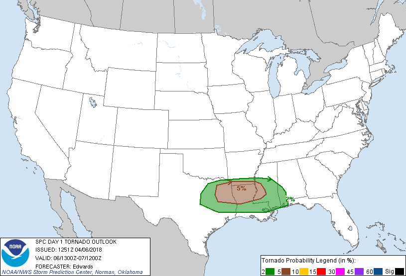
...North-central/northeast/east Texas to lower Mississippi Valley...
Widely scattered to scattered thunderstorms are evident from eastern
OK and parts of northeast TX across AR, in a zone of elevated
low-level warm advection, moisture transport and isentropic lift to
varying LFCs, north of the marine/warm front. Such development
should continue in a sporadic/episodic manner throughout the day,
with the approach of the southern High Plains shortwave trough and
broad, gradually eastward-shifting, 35-45-kt LLJ. Isolated severe
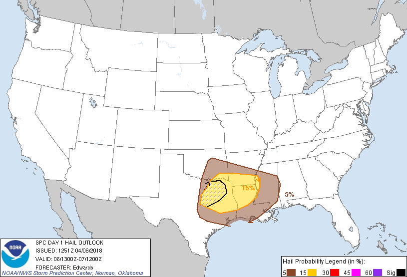
hail will be possible north of the warm front.
The best-organized severe threat is expected to develop as
convection near and north of the warm front, and near the
strengthening cold front, shifts southeastward and encounters
increasingly unstable, surface-based effective-inflow parcels
representative of the marine sector. Activity should aggregate
gradually into a primary QLCS, with elements both forward-
propagating southeastward across the Arklatex/Delta regions and
backbuilding over portions of north-central/northeast TX. Damaging
wind will be the main concern. Large hail is possible mainly near
the west end where deep-later lapse rates are steepest, with
isolated significant/2+ inch hail possible from any supercells that
can develop before being undercut my the deepening cold-frontal
slab. A few tornadoes may occur either from:
1. Mesovortices associated with QLCS LEWP/BOW features and/or
line-embedded supercells;
2. Any warm-sector supercells that can form and mature east of the
strongest EML over LA or the lower Delta region before being
overtaken by the QLCS. This modal potential is more conditional and
uncertain.
Forecast soundings ahead of the cold front and south of the
developing QLCS show lapse rates and MLCINH each increasing
westward. Surface dew points 60s F and pockets of favorable surface
heating should contribute to peak afternoon MLCAPE around 3000 J/kg
over north-central/northeast TX, decreasing to around 500-800 J/kg
in central MS, with maximal effective-shear magnitudes generally in
the 40-50-kt range.
Severe potential will be limited on the north and east fringes of
the outlook area by increasing lack of boundary-layer lapse
rates/buoyancy poleward of the fronts, on the west part by stronger
EML and cold-frontal undercutting, and on the south by
nocturnal/diabatic boundary-layer stabilization.
..Edwards/Kerr.. 04/06/2018
CLICK TO GET WUUS01 PTSDY1 PRODUCT
NOTE: THE NEXT DAY 1 OUTLOOK IS SCHEDULED BY 1630Z