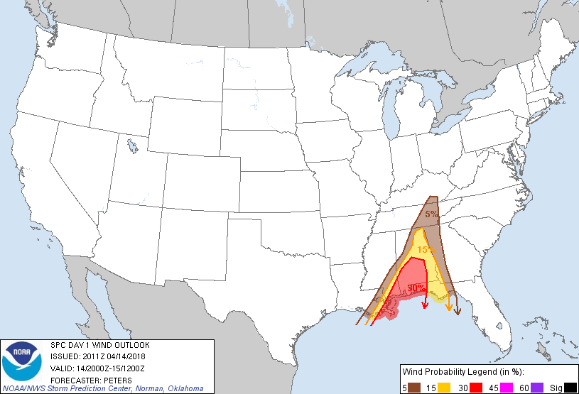
Probability of damaging thunderstorm winds or wind gusts of 50 knots or higher within 25 miles of a point. Hatched Area: 10% of greater probability of wind gusts 65 knots or greater within 25 miles of a point.
SPC AC 142011
Day 1 Convective Outlook
NWS Storm Prediction Center Norman OK
0311 PM CDT Sat Apr 14 2018
Valid 142000Z - 151200Z
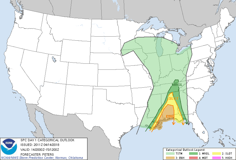
...THERE IS AN ENHANCED RISK OF SEVERE THUNDERSTORMS ACROSS
SOUTHEAST LA...SOUTHEAST MS...SOUTHERN AL...AND WESTERN FL
PANHANDLE...
...THERE IS A SLIGHT RISK OF SEVERE THUNDERSTORMS SURROUNDING THE
ENHANCED RISK AREA IN THE CENTRAL GULF COAST STATES...
...THERE IS A MARGINAL RISK OF SEVERE THUNDERSTORMS SURROUNDING THE
SLIGHT RISK AREA TO EASTERN TN...
...SUMMARY...
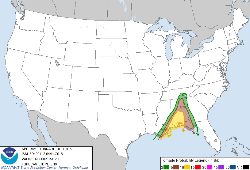
Scattered damaging winds and short-lived tornadoes are expected from
the central Gulf Coast to the Tennessee Valley, mainly through this
evening.
Given ongoing eastward advancement of the QLCS in AL, the western
portions of the categorical and severe probabilities have been
trimmed. Meanwhile, the Enhanced risk has been expanded east to
include more of southern AL and the western FL Panhandle for the
potential of storms to increase in intensity across far southeast
LA/MS and spread across southern AL and the adjacent FL Panhandle.
The environment across this region of the Gulf Coast will remain
moderately unstable and strongly sheared ahead of a shortwave trough
expected to track from the northwest Gulf of Mexico and across the
Enhanced risk into this evening and overnight. This ascent will be
enhanced later tonight as the larger-scale shortwave trough on TX
emerges east taking on a negative tilt.
The ongoing band of storms south of LA appears to be associated with
the arrival of this aforementioned forcing for ascent. The expected
CAPE/shear parameter space will favor damaging winds and a tornado
threat, as shear values support rotating updrafts embedded within
the line of storms, and with any preceding discrete cells.
Otherwise, the northern extent of the ongoing QLCS will continue to
advance east into a less unstable air mass resulting in a
diminishing trend of the overall severe weather threat.
..Peters.. 04/14/2018
.PREV DISCUSSION... /ISSUED 1116 AM CDT Sat Apr 14 2018/
A well-organized squall line with embedded bow/lewp structures
continues to progress eastward across parts of MS/LA into AL. A
combination of dewpoints in the mid/upper 60s and at least broken
sunshine will maintain MLCAPE values around 1000 J/kg ahead of the
line through most of the day. Local VAD hodographs and forecast
sounding data suggest strong low-level shear is present and will
persist across AL, maintaining the potential for rotating updrafts
and a few tornadoes. Some potential exists for isolated cells ahead
of the main line, which could result in an isolated tornado/wind
threat. However, present indications are that the squall line is
the primary severe threat.
This evening, the convective line will continue tracking eastward
into eastern AL where a more dry/stable low-level air mass is
expected to result in slow weakening. Farther south, the storms
will maintain some intensity across the FL Panhandle. Sufficient
instability/shear suggests that the risk of at least isolated
damaging wind gusts and/or tornadoes will persist through much of
the night.
CLICK TO GET WUUS01 PTSDY1 PRODUCT
NOTE: THE NEXT DAY 1 OUTLOOK IS SCHEDULED BY 0100Z