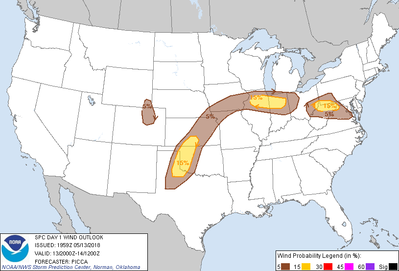
Probability of damaging thunderstorm winds or wind gusts of 50 knots or higher within 25 miles of a point. Hatched Area: 10% of greater probability of wind gusts 65 knots or greater within 25 miles of a point.
Day 1 Wind Risk
Area (sq. mi.)
Area Pop.
Some Larger Population Centers in Risk Area
15 %
65,896
6,437,478
Fort Wayne, IN...Aurora, IL...Naperville, IL...Joliet, IL...Gary, IN...
SPC AC 131959
Day 1 Convective Outlook
NWS Storm Prediction Center Norman OK
0259 PM CDT Sun May 13 2018
Valid 132000Z - 141200Z
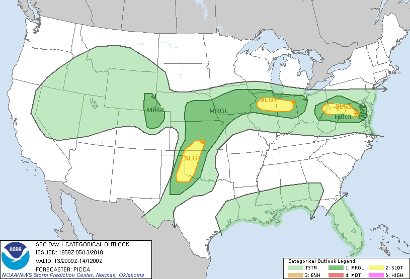
...THERE IS A SLIGHT RISK OF SEVERE THUNDERSTORMS FROM PARTS OF THE
APPALACHIANS TO THE MID-ATLANTIC...ACROSS PARTS OF NORTHERN
IL/IN...AND ACROSS PARTS OF THE SOUTHERN/CENTRAL PLAINS...
...SUMMARY...
Scattered severe storms remain possible across parts of the
Appalachians to Mid-Atlantic and southern/central Plains late this
afternoon and evening, as well as portions of northern Illinois and
Indiana late tonight.
...Appalachians to Mid-Atlantic...
Have made only minor adjustments to damaging wind probabilities,
primarily to account for some southwestward advance of the front
across Maryland and northern Virginia. Also expanded the marginal
risk (for hail/wind) slightly northward over western Pennsylvania,
where satellite and meso-analysis trends suggest some ongoing
heating/modest destabilization ahead of developing convection.
Farther southwest, convection also appears to be deepening within a
corridor of locally enhanced low-level confluence over eastern Ohio.
These cells should gradually spread east/southeast as they mature,
with an attendant threat for damaging winds and large hail.
Therefore, the slight risk remains unchanged.
...Illinois into Indiana...
Sizable uncertainty remains with the potential for severe weather
late tonight. Ongoing convection over southeastern Iowa remains
north of the surface front and elevated atop a stable layer.
Moreover, visible satellite trends suggest it is unlikely that this
complex's trajectory is favorable for eventually ingesting
surface-based parcels. In turn, these cells may weaken with eastward
extent, as elevated storm-relative inflow becomes less favorable for
convective maintenance.
The primary severe threat should thus remain with initially elevated
convection developing over Illinois late tonight. Nonetheless,
uncertainty persists with regards to an eventual convective complex
becoming at least partially surface based through the overnight as
it moves into Indiana. Assuming it gains some southward component of
propagation and becomes rooted near the surface, a damaging wind
threat would evolve late tonight. Therefore, no adjustments are made
to the ongoing slight risk, but may be needed with the 01Z update.
...Central Plains...
The marginal risk was expanded westward over parts of southern
Nebraska, where the terminus/focus of a low-level jet should combine
with steep mid-level lapse rates to foster some hail threat with
elevated cells overnight.
Additionally, the marginal risk in Colorado was expanded slightly
southward to account for visible satellite trends and the potential
for more eastward propagation with a discrete cell or two that may
develop and acquire mid-level rotation.
..Picca.. 05/13/2018
.PREV DISCUSSION... /ISSUED 1129 AM CDT Sun May 13 2018/
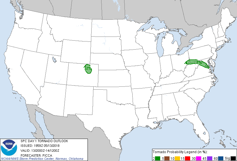
...Central Appalachians to Mid-Atlantic States...
Quasi-stationary front runs west/east across central OH into far
southwest PA before arcing southeast across northern/eastern VA.
Robust diabatic heating will occur in the warm sector within the
eastern extent of the massive EML plume emanating from the central
states. While a mid-level speed max is passing east of the region,
sufficient deep-layer shear will persist for a few supercells amid
MLCAPE around 600-1200 J/kg. Severe hail and damaging wind will be
the primary hazards, but a tornado is possible with any supercell
moving along the SRH-enriched front. Have upgraded to Slight Risk to
account for this potential.
...TX/OK/KS...
Influx of richer low-level moisture beneath very steep mid-level
lapse rates associated with a massive EML should result in large
warm-sector buoyancy to about 3000 J/kg to the east of the TX
dryline and southeast of a quasi-stationary front in KS. Scattered
storms (more numerous than previous days) should develop along the
dryline in the late afternoon. Deep-layer shear will be modest
(effective values around 20-30 kt) even with a veering wind profile
with height. Even so, the impressive thermodynamic environment will
favor large hail and severe wind gusts with multicells and a few
embedded supercells. Convection should largely weaken as inhibition
strengthens greatly east of the dryline after sunset.
...IA/IL/IN...
Low-level warm advection will again be centered on the IA to
northern IL area tonight resulting in widespread elevated convection
north of the quasi-stationary front expected to lie along the IA/MO
border east through central IL/IN. While elevated buoyancy will be
sufficient for a severe hail risk, rapid evolution to a
west/east-oriented cluster should marginalize this threat. However,
some CAMs suggest that this elevated MCS will organize into a
forward-propagating bow across parts of northern IL/IN by 09-12Z
Monday morning where the surface front becomes increasingly diffuse.
A risk for strong to isolated severe wind gusts may develop in spite
of large inhibition for surface-based parcels.
...CO/WY...
Repeated initiation of widely scattered storms is anticipated during
the late afternoon and evening within a persistent upslope flow
regime. Winds aloft and vertical shear along the eastern periphery
of the Great Basin upper low will be sufficient for a couple
supercells developing off the Front Range. Severe hail should be the
primary hazard. Given a pervasive stratus deck across much of the
central High Plains, the tornado/wind risk will likely be confined
to where stronger diabatic heating can occur. This appears most
probable near/north of the Denver cyclone where at least pockets of
greater heating should occur along the Palmer Divide.
CLICK TO GET WUUS01 PTSDY1 PRODUCT
NOTE: THE NEXT DAY 1 OUTLOOK IS SCHEDULED BY 0100Z