New York, NY...Philadelphia, PA...Boston, MA...Newark, NJ...Jersey City, NJ...
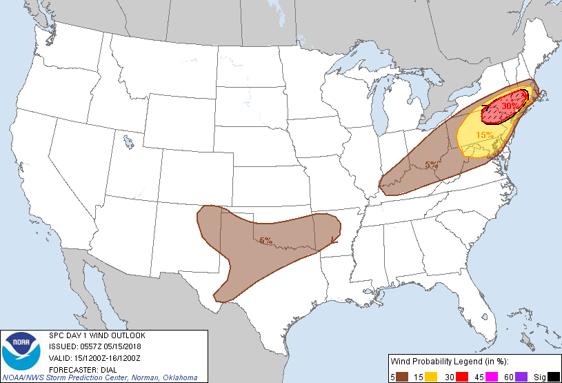
Probabilistic Damaging Wind Graphic
Probability of damaging thunderstorm winds or wind gusts of 50 knots or higher within 25 miles of a point. Hatched Area: 10% of greater probability of wind gusts 65 knots or greater within 25 miles of a point.
New York, NY...Philadelphia, PA...Baltimore, MD...Washington, DC...Newark, NJ...
5 %
298,192
35,185,111
Columbus, OH...Fort Worth, TX...Boston, MA...Oklahoma City, OK...Arlington, TX...
SPC AC 150557
Day 1 Convective Outlook
NWS Storm Prediction Center Norman OK
1257 AM CDT Tue May 15 2018
Valid 151200Z - 161200Z
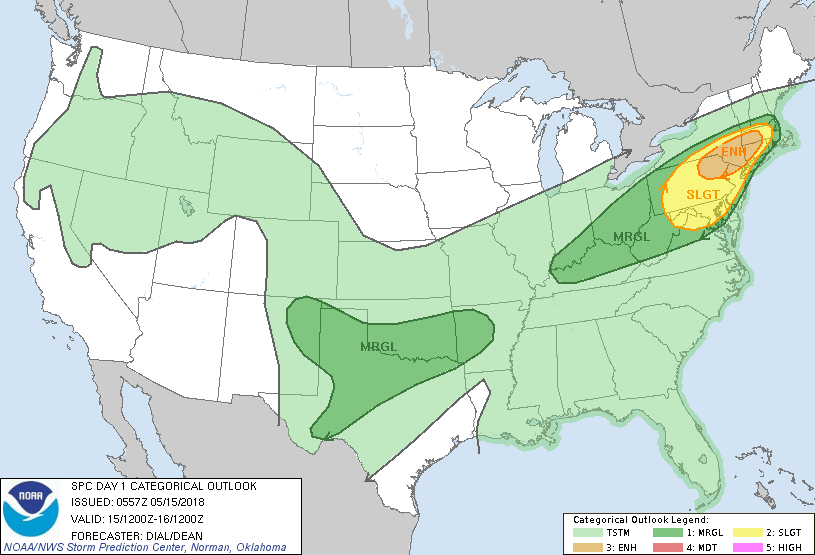
...THERE IS AN ENHANCED RISK OF SEVERE THUNDERSTORMS OVER A PORTION
OF THE NORTHEAST STATES INTO NEW ENGLAND...
...SUMMARY...
Severe thunderstorms, capable of significant damaging wind as well
as hail and a few tornadoes are forecast across a part of the
Northeast States and the Middle Atlantic this afternoon into the
evening. Other strong to severe storms will impact portions of
northeast New Mexico into the southern Plains with isolated
downburst winds and hail possible.
...Northeast States through Middle Atlantic...
Low to mid 60s F near-surface dewpoints will accompany a warm front
into southern New England later today. Early warm advection storms
now developing over the Mid Atlantic region will probably diminish
later this morning as initial vorticity maximum and its attendant
low-level jet move offshore. Diabatic warming is likely south of the
warm front from southern New England into the Middle Atlantic. The
eastern expansion of steep lapse rate plume in conjunction with
low-level theta-e advection and solar insolation should contribute
to moderate instability with 1500-2000 J/kg MLCAPE. A vorticity
maximum currently over eastern IL will become absorbed within
stronger winds aloft situated within southern periphery of the
synoptic-scale Hudson Bay vortex. This feature will subsequently
accelerate through the Northeast States and southern New England
during the day. Current indications are that storms will initiate in
association with the progressive vorticity maximum as well as along
a southeast-advancing cold front. Wind profiles aloft will
strengthen with effective-bulk shear exceeding 50 kt, but low-level
hodographs may remain somewhat modest due to veered low-level winds.
The thermodynamic and kinematic environment are expected to become
very favorable for organized severe storms with potential for a few
supercells, but storms should eventually evolve into linear segments
with embedded bowing structures capable of significant wind damage
from northeast PA into southern NY and southern New England.
Influence of the marine layer may contribute to a gradual weakening
as activity approaches the coastal region.
...Southern Plains into the lower Mississippi Valley region...
With steep mid-level lapse rates still in place, the atmosphere will
likely become moderately to strongly unstable during the afternoon
across the southern Plains region. Several areas of thunderstorm
development are expected in this region today including a few strong
to severe multicells capable of mainly downburst winds in
association with an MCV that will move from OK into AR during the
afternoon.
Other storms may develop in post-frontal upslope regime over the
higher terrain of northern NM where vertical shear will be at least
marginally supportive of some supercell structures. This activity
will spread east into the High Plains with a threat for mainly
downburst winds and hail.
Additional storms are expected farther south across west TX along
the dryline. These storms should be primarily multicell in
character, but the thermodynamic environment with 2500-3000 J/kg
MLCAPE will support a threat for downburst winds and large hail.
..Dial/Dean.. 05/15/2018
CLICK TO GET WUUS01 PTSDY1 PRODUCT
NOTE: THE NEXT DAY 1 OUTLOOK IS SCHEDULED BY 1300Z