Probability of a tornado within 25 miles of a point. Hatched Area: 10% or greater probability of EF2 - EF5 tornadoes within 25 miles of a point.
Day 1 Tornado Risk
Area (sq. mi.)
Area Pop.
Some Larger Population Centers in Risk Area
5 %
12,785
1,467,994
Rockford, IL...Davenport, IA...Janesville, WI...Moline, IL...Rock Island, IL...
2 %
77,845
11,565,409
Kansas City, MO...Madison, WI...Aurora, IL...Overland Park, KS...Kansas City, KS...
Probabilistic Damaging Wind Graphic
Probability of damaging thunderstorm winds or wind gusts of 50 knots or higher within 25 miles of a point. Hatched Area: 10% of greater probability of wind gusts 65 knots or greater within 25 miles of a point.
Day 1 Wind Risk
Area (sq. mi.)
Area Pop.
Some Larger Population Centers in Risk Area
30 %
23,407
1,089,780
Columbia, MO...Joplin, MO...Jefferson City, MO...Sedalia, MO...Pittsburg, KS...
15 %
99,563
15,083,313
Kansas City, MO...St. Louis, MO...Aurora, IL...Overland Park, KS...Rockford, IL...
SPC AC 260559
Day 1 Convective Outlook
NWS Storm Prediction Center Norman OK
1259 AM CDT Tue Jun 26 2018
Valid 261200Z - 271200Z
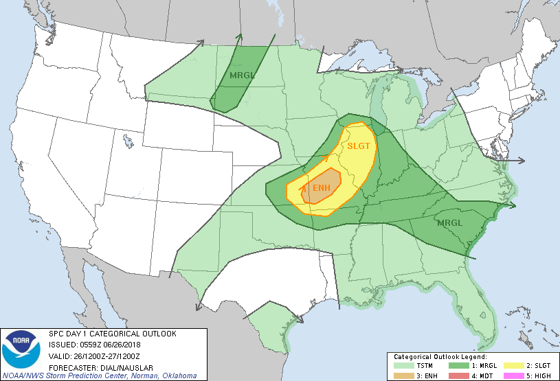
...THERE IS AN ENHANCED RISK OF SEVERE THUNDERSTORMS FROM EASTERN
KANSAS INTO A PORTION OF THE MIDDLE MISSISSIPPI VALLEY...
...SUMMARY...
Severe storms are forecast across the lower Missouri and middle
Mississippi Valley this afternoon and evening. Other strong to
severe storms are possible from the Tennessee Valley into a portion
of the Southeast States.
...Synopsis...
Shortwave trough initially over the middle MS Valley region by 12Z
will move east into the OH Valley tonight. Attendant weak surface
low will develop into east IA this afternoon with warm front
extending east through IL and IN. Trailing cold front will extend
southwest through northern MO and central KS and move slowly
southeast during the period. Upstream shortwave trough will advance
east through southern Canada, glancing the international border of
northern MT, reaching northern ND this evening.
...Central and eastern KS through the middle Mississippi Valley
region...
Early storms will likely be ongoing across southern MO along warm
conveyor belt. This activity will shift east and southeast during
the day. A few other storms may be ongoing over northern MO in
closer proximity to upper low circulation. Richer low level moisture
with surface dewpoints near 70 F will advect through east KS and MO
beneath eastern periphery of elevated mixed layer resulting in
destabilization with a corridor of 2000-3000 J/kg MLCAPE from
eastern KS through central MO. Ascent with several lobes of
vorticity rotating through upper low circulation will contribute to
the development of storms anywhere from central KS east through
central and northern MO today. Belt of stronger winds along southern
periphery of the upper low circulation will contribute to 30-40 kt
effective bulk shear supportive of both multicell and some supercell
structures, but storms may have a tendency to evolve into clusters
and line segments with damaging wind and large hail the main
threats.
...Iowa through northern Illinois and southern Wisconsin...
Modest instability is expected in warm sector. Storms will continue
developing in association with vorticity maxima rotating through
upper low circulation, and 35-40 kt effective bulk shear will
support some supercell structures. If sufficient boundary layer
destabilization occurs, threat will exist for a few tornadoes as
storms move northeast and interact with warm front across eastern IA
into northern IL and southern WI this afternoon into early evening.
...Southeast States...
Several clusters of multicell storms will develop through the TN
Valley and southeast states where the thermodynamic environment will
support a threat of wet microbursts during the afternoon.
...Northern Plains...
Storms are expected to develop along progressive cold front,
especially across western and central ND this afternoon and evening.
Moderate instability and steep lapse rates with inverted-V boundary
layers will support a threat for a few instances of downburst winds
and hail. At this time, it appears coverage of severe events will
remain too isolated for more than a marginal risk category.
..Dial/Nauslar.. 06/26/2018
CLICK TO GET WUUS01 PTSDY1 PRODUCT
NOTE: THE NEXT DAY 1 OUTLOOK IS SCHEDULED BY 1300Z