SPC AC 200643
Day 2 Convective Outlook
NWS Storm Prediction Center Norman OK
1243 AM CST Sat Jan 20 2018
Valid 211200Z - 221200Z
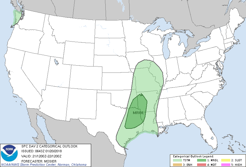
...THERE IS A MARGINAL RISK OF SEVERE THUNDERSTORMS FOR PORTIONS OF
EAST TX...SOUTHEAST OK...WESTERN AR AND NORTHWEST LA...
...SUMMARY...
Isolated severe thunderstorms are possible Sunday afternoon and
evening from east Texas northeastward into western Arkansas.
...Synopsis...
A strong shortwave trough will progress eastward/east-northeastward
from the Four Corners region into central Plains. Strong low- to
mid-level southwesterly flow attendant to this shortwave will spread
over the southern/central Plains and eventually into the low/mid MS
Valley. Surface low associated with this system is expected to move
northeastward through central KS into the lower MO River Valley
while becoming increasingly vertically stacked as the overall system
matures. As this occurs, a fast-moving Pacific cold front/dryline
will sweep across the southern Plains and lower MS Valley,
contributing to thunderstorm development as it encounters a moist
and marginally unstable airmass. A few isolated severe storms are
possible (discussed in more detail below).
Farther west, a strong shortwave trough will move through the
Pacific Northwest Sunday afternoon and overnight. Frontal band
associated with this shortwave will likely move onshore early
Sunday. Relatively warm temperatures aloft should keep convection
within this band shallow. However, cooling mid-level temperatures in
the wake of this band will contribute to enough instability for
isolated lightning strikes within the cellular post-frontal
convection.
...East TX...Ark-La-Tex Region...
A tightened surface pressure gradient and strengthening low-level
flow will result in moist return flow from the lower TX coast into
southern portions the Ozark Plateau. Expectation is for low 60s
dewpoints to reach as far north as far southeast OK/far southwest AR
by the late afternoon. Despite this increase in low-level moisture,
instability will be tempered by significant warm-sector cloudiness
and, as a result, reduced daytime heating. Even so, enough
instability will exist to support thunderstorm development as
forcing for ascent provided by both the cold front and the
approaching shortwave trough move through the region. Initial
thunderstorm development is expected along or just west of the I-35
corridor during the late afternoon/early evening.
The depth and strength of the flow aloft will favor fast storm
motion and the potential for a few storms to produce gusty winds.
Primary uncertainty is currently the coverage of any
damaging-wind-producing storms, which will be tempered by limited
surface-based instability. Resulting uncertainty is too high to
introduce slight-risk-equivalent probabilities with this forecast,
although higher probabilities may be needed in subsequent forecasts
if confidence in higher severe coverage increases.
..Mosier.. 01/20/2018
CLICK TO GET WUUS02 PTSDY2 PRODUCT
NOTE: THE NEXT DAY 2 OUTLOOK IS SCHEDULED BY 1730Z