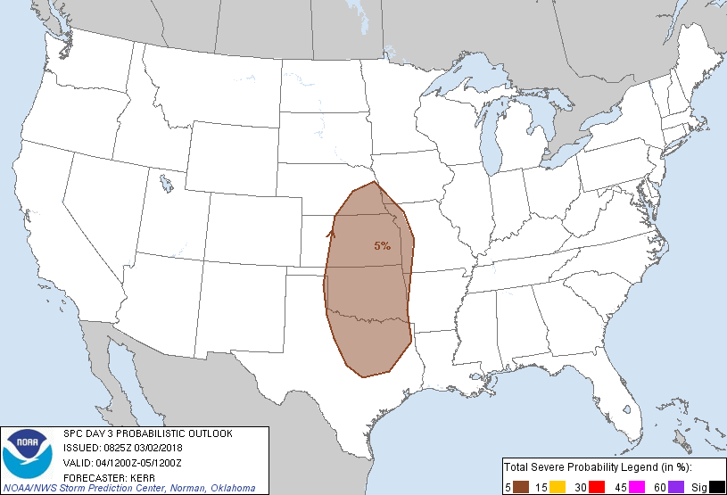
Dallas, TX...Fort Worth, TX...Oklahoma City, OK...Kansas City, MO...Omaha, NE...
Probabilistic Graphic
Probability of severe weather within 25 miles of a point. Hatched Area: 10% or greater probability of significant severe within 25 miles of a point.
Day 3 Prob. Risk
Area (sq. mi.)
Area Pop.
Some Larger Population Centers in Risk Area
5 %
216,272
18,978,976
Dallas, TX...Fort Worth, TX...Oklahoma City, OK...Kansas City, MO...Omaha, NE...
SPC AC 020825
Day 3 Convective Outlook
NWS Storm Prediction Center Norman OK
0225 AM CST Fri Mar 02 2018
Valid 041200Z - 051200Z
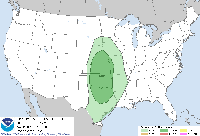
...THERE IS A MARGINAL RISK OF SEVERE THUNDERSTORMS SUNDAY AFTERNOON
AND EVENING ACROSS PARTS OF THE CENTRAL AND SOUTHERN PLAINS...
...SUMMARY...
Widely scattered strong storms may impact portions of the central
and southern Plains Sunday afternoon and evening, accompanied by at
least some risk for severe weather.
...Discussion...
Blocking appears likely to remain prominent within the large-scale
pattern across parts of eastern Canada into the western Atlantic
during this period. However, models do indicate that upper
troughing, including one vigorous short wave, will emerge from the
intermountain west and suppress upper ridging east of the Rockies,
as it progresses across the Rockies into the northern and central
Plains Sunday through Sunday night. Guidance continues to indicate
that the short wave impulse will provide support for fairly
significant surface cyclogenesis from the central High Plains
through the middle Missouri Valley. The short wave may be preceded
on its southern through southeastern periphery (across Oklahoma and
northern Texas into the lower Mississippi Valley) by another
substantive impulse of subtropical eastern Pacific origins.
A modest return flow of moisture off a modifying boundary layer over
the western Gulf of Mexico probably will already be underway by
early Sunday. However, there may be little further appreciable
increase in moisture quality (mid 60s across central/eastern Texas)
through the period, hampered by low-level drying in the wake of the
broad, deep cyclone over the western Atlantic. And northward
moisture return within the warm sector into the central Plains may
be confined to a relatively narrow wedge. But this is expected to
take place in the presence of at least modestly steep lower/mid
tropospheric lapse rates, beneath a plume of elevated mixed layer
air emerging from the Mexican Plateau, prior to the onset of
mid-level cooling associated with the approaching mid-latitude
trough. It does appear that the stronger mid-level cooling may
advance eastward to the north of the better low-level moisture
across Texas.
...Central and southern Plains...
Convective potential for Sunday through Sunday night remains
somewhat unclear due to a number of uncertainties (some already
alluded to). The environment appears potentially supportive of a
window of opportunity for supercell development, but any potential
for boundary-layer based supercells may be confined to a rather
narrow corridor across parts of northwest Texas, the eastern Texas
Panhandle and adjacent portions of western Oklahoma through west
central Kansas. This would be along the dry line during the late
afternoon and early evening. However, most current model output is
suggestive that any thunderstorm development across this region will
be isolated at best.
There currently appears a stronger signal that scattered
thunderstorm development may initiate east of the dry line, perhaps
across parts of northwest Texas into western Oklahoma by midday,
before spreading eastward toward the Ozark Plateau, and perhaps
northward toward the mid/lower Missouri Valley ahead of the
mid-latitude impulse. Much of this seems likely to be elevated
above a cooler/stable boundary layer, but the lapse rates and
favorable shear may support at least a marginal severe hail risk
across the lower Plains before this threat diminishes to the east.
In the wake of the subtropical perturbation, and ahead of the
southern edge of the mid-latitude trough axis, it also does not seem
out of the question that mid-level inhibition could weaken
sufficiently for isolated boundary layer supercell development
across parts of central/northeast Texas before the boundary layer
stabilizes late Sunday evening.
..Kerr.. 03/02/2018
CLICK TO GET WUUS03 PTSDY3 PRODUCT
NOTE: THE NEXT DAY 3 OUTLOOK IS SCHEDULED BY 0830Z