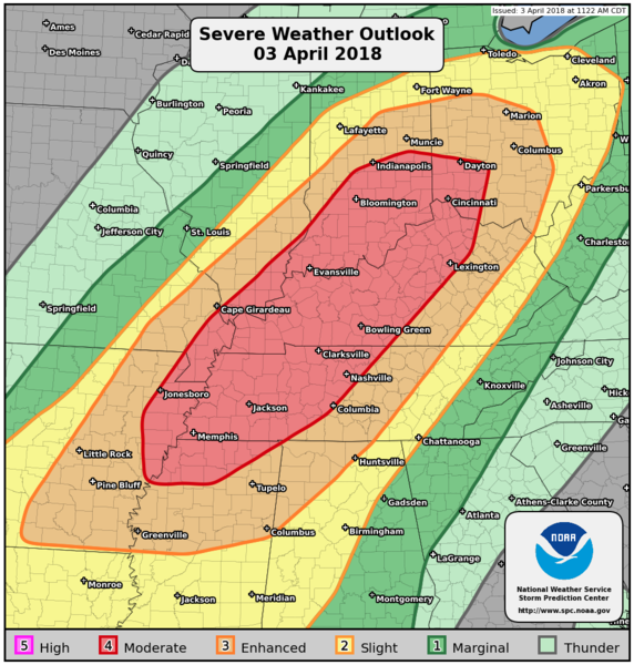
   ZCZC SPCPWOSPC ALL
   WOUS40 KWNS 031631
   ALZ000-ARZ000-ILZ000-INZ000-KYZ000-MOZ000-MSZ000-OHZ000-TNZ000-040200-

   PUBLIC SEVERE WEATHER OUTLOOK
   NWS STORM PREDICTION CENTER NORMAN OK
   1131 AM CDT TUE APR 03 2018

   ...Severe thunderstorms expected over parts of the Mid-South, Ohio,
   and mid Mississippi Valley regions later today and tonight...

   * LOCATIONS...
     Kentucky
     Tennessee
     Indiana
     Mississippi
     Arkansas
     Ohio
     Illinois
     Missouri
     Alabama

   * HAZARDS...
     Widespread damaging winds, some hurricane force
     A few intense tornadoes
     Scattered large hail, some baseball size

   * SUMMARY...
     A Moderate Risk for thunderstorms producing widespread damaging
     winds, large hail, and a few tornadoes exists over parts of the
     Ohio, mid Mississippi Valley and Mid-South regions.

   Preparedness actions...

   Review your severe weather safety procedures for the possibility
   of dangerous weather today. Stay tuned to NOAA Weather Radio,
   weather.gov, or other media for watches and warnings. A watch
   means that conditions are favorable for severe thunderstorms
   over the next several hours. If a severe thunderstorm warning is
   issued for your area, move to a place of safety, ideally in an
   interior room on the lowest floor of a sturdy building.

   &&

   ..Picca.. 04/03/2018

   $$
|
